A printable PDF version of the document is available at the end of the page.
Regulation 19 Pre-Submission Draft Changes to the Leeds Local Plan Update
The changes to the policy wording and supporting text are itemised below:-
New text is shown as
bold underlined
Deleted text is shown as
bold strike through
To assist readers, the full text of the Local Plan Update showing the Pre-Submission Changes as tracked changes is available here.
Consultation comments should relate to the Publication Draft Pre-Submission Changes only and not revisit the remaining original policy wording and supporting text, which was subject to consultation in 2022.
| Pre-Submission Change Number | Topic Heading | Para. Number /Policy Ref in LPU Document | Details of Pre-Submission Change | Reason for Change | ||||||||||||||||||||||||||||||||||||
|---|---|---|---|---|---|---|---|---|---|---|---|---|---|---|---|---|---|---|---|---|---|---|---|---|---|---|---|---|---|---|---|---|---|---|---|---|---|---|---|---|
| 1 | Explanatory note | 1st para. | Revise second sentence to read: "As these policies will have the effect of amending and updating the existing Core Strategy (2019 as amended) and the Natural Resources and Waste Local Plan 2013 (Minerals Transport polices 2015), the document specifies which parts of the adopted Core Strategy and Natural Resources and Waste Local Plan are proposed to be amended." |
For clarity | ||||||||||||||||||||||||||||||||||||
| 2 | Overall approach | 4.0.9 |
Insert new text after end of second bullet point: "and encouraging the re-use of buildings rather than demolition" |
To reflect circular economy principles which are an important part of carbon reduction | ||||||||||||||||||||||||||||||||||||
| 3 | Overall approach | Policy SP0 |
Amend POLICY SP0 to read: Strategic policy SP0: Climate Change Mitigation and Adaptation Development must contribute to the reduction of carbon emissions in Leeds. New developments will achieve 100% net zero operational carbon reductions (on 2000 levels) to help make significant progress to the District being net zero by 2030. New developments will support the District's wider science-based Scope 1 and 2 carbon reduction targets (on 2000 levels) as follows: i. 85% by 2030 ii. 95% by 2035 iii. 97% by 2040 iv. 99% by 2045 v. 100% by 2050 This will be achieved by: 1. Minimising carbon emissions, including by: a. Developing in sustainable locations in accordance with Policy SP1 and SP1A b. Supporting the city centre, town and local centres as sustainable hubs in accordance with Policies SP2, P2, P3 and P8 c. Supporting the delivery of d. Building zero carbon operational buildings in accordance with Policies EN1 e. Improving the sustainability of buildings in accordance with Policy EN2 f. Taking opportunities to incorporate Whole Life Cycle carbon emissions into buildings in accordance with Policy EN1 g.Taking opportunities to incorporate and connect to renewable and low carbon sources of heat and power in accordance with Policies EN1, EN2 and EN4 h. Promoting the generation of renewable energy within the District in accordance with Policy EN3 i. Reducing the need to travel by car and encouraging sustainable travel in accordance with Policy SP1, SP11, EN9, T1, T2 and Minerals 13 j. Delivering densities that make the most of accessible sites in accordance with Policy H3 k. Incorporating electric vehicles charging points in accordance with Policy EN8 l. Encouraging more food growing in the District so as to reduce food miles in accordance with Policy F1. m.
2. Adapting to the impacts of climate change, including by: a. Restricting inappropriate development in high flood risk areas and managing flood risk in association with Policies EN5 and WATER 3, 4, 5, 6 and 7 b. Delivering net gains for biodiversity that help support plants and animals adjust to changing climates in accordance with Policy G9 c. Incorporating water and energy efficiency measures into the active and passive design of new buildings in accordance with EN2 and WATER 1 d. Providing Green and Blue Infrastructure and Green Spaces which provide shade, reduce overheating and mitigate air pollution in urban areas in accordance with Policies G1 and G4B 3. Ensuring resilient and healthy places, including by: a. Promoting the creation and growth of b. Making best use of land, including in the inner city which is more vulnerable to a changing climate, to ensure that it can perform carbon adaptation roles such as laying out of Green Space and protecting trees in accordance with Policy G2A c. Improving the design of places, in accordance with Policy P10 d. Improving the health and well-being of residents of Leeds, in accordance with Policy P10A. 4.Maximising carbon storage and sequestration, including by: a. Protecting, enhancing and extending Green and Blue Infrastructure that helps sequester carbon in accordance with Policies SP13 and G1 b. Protecting habitats that fulfil carbon storage functions in accordance with Policy G8 c. Protecting and planting trees and recognising their essential role for carbon sequestration as well as amenity and ecology, in accordance with Policies G2A and G2C. 5. Supporting the robustness of the District's biodiversity, including by: a. Protecting, enhancing and extending Green and Blue Infrastructure that helps create places, corridors and stepping stones for nature in accordance with Policies SP13 and G1 b. Identifying opportunities to create more biodiverse developments in accordance with Policy G9 and SP1B c. Protecting important habitats from development and harm in accordance with Policy G8 d. Seeking biodiversity net gain from all relevant development in accordance with Policy G9 e. Protecting and planting trees, in accordance with Policies G2CD. |
Reference to 20 minute neighbourhoods replaced to reflect wording change to SP1A Reference to circular economy principles added as they are an important part of carbon reduction. Therefore, included for completeness. The Government states that "the UK is committed to moving towards a more circular economy which will see us keeping resources in use as long as possible, extracting maximum value from them, minimizing waste and promoting resource efficiency". (Source: Circular Economy Package policy statement DEFRA 30 July 2020) A more detailed policy on the circular economy will be included in LLPReference to 20 minute neighbourhoods replaced to reflect wording change to SP1A Revision to update policy reference |
||||||||||||||||||||||||||||||||||||
| 4 | Carbon Reduction | Insert paragraph numbering for section | For clarity and consistency | |||||||||||||||||||||||||||||||||||||
| 5 |
Carbon Reduction Whole Life Cycle Carbon Assessments |
After 8th para. |
After 8th paragraph insert: "Whole life cycle carbon assessments will be monitored and this policy will be subject to a future plan review to set a benchmark figure for future development to achieve." |
Text moved from policy EN1A as does not refer to a specific date for review | ||||||||||||||||||||||||||||||||||||
| 6 |
Carbon Reduction Whole Life Cycle Carbon Assessments |
9th para. under |
Delete 9th paragraph and replace with: "Where an application is seeking to demolish an existing building, then the applicant will have to demonstrate that the new development would have a lowr carbon cost over its lifetime through the calculation of its embodied carbon and projected operational carbon emissions when measured against reusing the existing building(s). If the building is currently not in use, or in a state of disrepair, an estimation of its energy demand for the proposed use should be provided by the applicant.Existing buildings contain significant amounts of embodied carbon that can be wasted through demolition. In order for applications to consider whether demolition is necessary, and if it is, how those existing materials can be reused or recycled through a new development, Policy EN1A Part B requires applicants to demonstrate how existing buildings may not be suitable for the proposed development and how materials should be recycled and reused if demolition is necessary.Where materials cannot be resused or recycled, justification for this should be submitted through the application. Justification for why demolition of buildings may be required include:
|
Changes to supportive text relates to policy wording amendments. | ||||||||||||||||||||||||||||||||||||
| 7 |
Carbon Reduction Whole Life Cycle Carbon Assessments |
Policy EN1 PART A |
Amend policy to read:
EN1 1. All major development should calculate the whole life cycle carbon emissions using a nationally recognised assessment methodology and demonstrate actions to reduce life-cycle carbon emissions of the development. 2. 3. Minor and household applications should consider the whole life cycle emissions of the development and make reasonable efforts to reduce those emissions using natural and recycled materials in the construction process. This should be demonstrated by assessing the scheme against the Council's whole life cycle carbon assessment checklist for minor and household applications. Whole life cycle carbon assessments will be monitored and this policy will be subject to a future plan review to set a benchmark figure for future development to achieve. "Where an application is seeking to demolish a building, the applicant must demonstrate how the proposed use is not suitable for the existing buildings on site. Once it has been demonstrated that the proposed use is not suitable for the existing building, applications will need to demonstrate how they will reuse and recycle materials created through the demolition. Justification will be required where applicants believe that materials cannot be reused or recycled." |
Policy intention is to retain embodied carbon in existing buildings. Previous methodology was not implementable and therefore not effective. | ||||||||||||||||||||||||||||||||||||
| 8 |
Carbon Reduction Operational Energy |
2nd para. under Operational Energy |
Revise 3rd sentence in the to read:
"However Part L does not calculate |
To reflect why we are moving away from Part L as a method to deliver net zero operational energy buildings. | ||||||||||||||||||||||||||||||||||||
| 9 |
Carbon Reduction Operational Energy |
3rd para. under Operational Energy | Revise 1st sentence to remove "Part" in reference to Policy EN1 and add "by 2030" at end of sentence. | For clarity and to reflect the timescale set by policy EN1 | ||||||||||||||||||||||||||||||||||||
| 10 |
CARBON REDUCTION Operational Energy |
3rd para. under Operational Energy | Revise 4th sentence to read: "…be that through onsite and or offsite generation with financial contributions as a last resort." |
To acknowledge that offsetting is required for certain building types to be 'net' zero | ||||||||||||||||||||||||||||||||||||
| 11 |
CARBON REDUCTION Operational Energy |
4th para. under Operational Energy | Revise 3rd sentence remove "Energy Use Intensity" and add "demand" after operational energy. Add new sentence at end of paragraph to read: "This is further justified as reduced energy needs will lower the costs of heat and power for the occupiers/end users." | For clarity | ||||||||||||||||||||||||||||||||||||
| 12 |
Carbon Reduction Operational Energy |
6th para. under Operational Energy |
Insert the following sentence at start of paragraph to read: "New development will be expected to be 'fossil fuel free'" |
The policy previously restricted development from using gas boilers and electric resistive heating. We feel that this wording would ensure no fossil fuel-based energy would be used onsite (gas boilers and any others) whilst potentially allowing electric resistive heating in certain scenarios | ||||||||||||||||||||||||||||||||||||
| 13 |
Carbon Reduction Operational Energy |
6th para. under Operational Energy |
Insert the following sentence at start of paragraph to read: "Fossil fuel plants onsite may be seen as acceptable where:
|
To reflect comments made during consultation by NHS Trust about how certain uses have more specialised energy needs. | ||||||||||||||||||||||||||||||||||||
| 14 | 7th para. under Operational Energy |
Revise paragraph to read: In order |
For clarity This is relevant to Part L building regulation calculations, which we have now moved away from using. |
|||||||||||||||||||||||||||||||||||||
| 15 |
Carbon Reduction Operational Energy |
After 7th para. under Operational Energy |
Insert new paragraph: "Up until the end of the transition period on 31st December 2026, applications will have to demonstrate how they have maximised fabric efficiency and onsite renewable energy generation with an aim to meet the transitional EUI and Space Heating Demand targets found within the policy. The Council understands that the heating technologies, supply chains and skill base may not currently be at the required national level to deliver all buildings in all locations to the standards detailed in the policy. |
To reflect the new policy wording and intent and justify why a transition period is required. | ||||||||||||||||||||||||||||||||||||
| 16 |
Carbon Reduction Operational Energy |
8th para. under Operational Energy |
Revise paragraph to read: Where applications submitted after the 1st January 2027 • Site constraints resulting in a lack of potential for on-site renewable energy generation equal to the buildings operational energy. • Historic buildings where In such circumstances robust justification for not achieving |
To reflect changes in policy wording and provide clarification where offsetting may be required. | ||||||||||||||||||||||||||||||||||||
| 17 |
Carbon Reduction Operational Energy |
9th para. under Operational Energy |
Delete the following paragraph: "The £/tonne of carbon commuted sum in which the Council will levy to developers is based on the best available science on the true cost of carbon, and on established practice. The UK Government provides an official £/tonne of carbon emissions which should be taken into account and as of 2022, the cost of carbon is set at £248/tonne, and this will increase to £280/tonne by 2030. The contributions in lieu will be used to deliver Council run projects that help reduce carbon across the district." |
Policy EN1B has been amended to require buildings to deliver an operational energy balance of zero after a transition period. Buildings are expected to achieve this through the delivery of renewable energy onsite, and where not possible, offsite through financial contributions. Therefore the financial offsetting mechanism has changed from a carbon based figure to a sum calculated from the installation of meeting the residual renewable energy cost. | ||||||||||||||||||||||||||||||||||||
| 18 |
Carbon Reduction Operational Energy |
After 9th para. under Operational Energy |
Insert the following two paragraphs: "Following the end of the transition period in 2026, applications that can not generate the renewable Shortfall between annual energy and renewable energy generation onsite (kWh/m2) X cost of PV installation offset figure
The financial offset multiplier is linked to the Government's solar photovoltaic cost dataset and the cost per kW for 10-50 kW installations. The Council will provide an annual update of the offsetting value to reflect any amendments to the Government's cost dataset with. |
Previous methodology was carbon based, however we have moved towards an offset value based on the cost of delivering the renewable energy that is not possible onsite, offsite. As our Policy uses EUIs, it makes more sense to calculate this way as evidenced by Cornwall and Bath and North East Somerset's adopted plans. | ||||||||||||||||||||||||||||||||||||
| 19 |
Carbon Reduction Operational Energy |
9th para. under Operational Energy |
Before text "These will include" insert new sentence to read: "Financial contributions collected through offsetting will go towards renewable energy generation |
For clarity on use of offsetting contributions. | ||||||||||||||||||||||||||||||||||||
| 20 |
Carbon Reduction Operational Energy |
10th para. under Operational Energy |
Revise paragraph to read: "The above projects are not exhaustive, and liable to change as the Council continues to support and introduce new |
For clarity | ||||||||||||||||||||||||||||||||||||
| 21 |
Carbon Reduction Operational Energy |
Policy EN1 Part B |
Revise Policy EN1 Part B to read: EN1 All new development must demonstrate that the buildings will achieve net zero operational carbon emissions in line with the following hierarchy: Minimise carbon emissions through passive design principles including fabric efficiency measures. Following carbon minimisation in Step 1, include renewable energy onsite to deliver an annual net zero carbon balance (including regulated and unregulated emissions) Exceptionally and subject to a demonstration of technical or feasibility constraints, all remaining operational carbon for a 30-year timeframe should be offset through a £248/tonne financial contribution to the Council to deliver carbon savings locally. This will increase to £280/tonne by 2030. Gas boilers and direct electric resistive heating will not be supported. Planning applications need to be supported by energy statements (pre and post construction) that demonstrate how the development meets net zero operational carbon An energy statement at the planning application stage will be required to demonstrate how energy efficient design and demand reduction measures meet the following Energy Use Intensity targets:
Development Type Housing 35 kWh/m2/year
Commercial Offices
Schools
Offices 55 kWh/m2/year
Multi-residential
(student accommodation etc) Retail
Leisure
Research Facility
Higher education
GP Surgery 55 kWh/m2/year
Hotel 55 kWh/m2/year
A post construction energy statement will be required before occupation. Up to the 31st of December 2026, all new development must:
•
•
• In order to achieve the above, applications will meet the following Transitional Energy Use Intensity (EUI) and Space Heating Demand targets:
Where the above standards are not met, applicants will be expected to demonstrate the technical or policy
Planning applications need to be supported by energy statements (pre and post construction
From 1st January 2027, all new development must demonstrate how it
•
•
•
•
Planning applications need to be supported by energy statements (pre and post construction) that demonstrate how the development delivers a net zero operational energy balance. Developments that will be exempt from this policy are: The above requirements will not apply to: 1. Buildings exempt from building regulations 2. Alterations and extensions to buildings of up to 1,000 square metres 3.Change of use or conversion of buildings
5.4 Buildings which have an intended life of less than two years
6.5 Gypsy and Traveller and Showpeople For all such exceptions development must show how efforts to reduce carbon emissions have been considered, in accordance with current good practice. |
The policy has been amended to reflect comments received through the consultation. A transition period has been introduced to allow the building industry time to prepare of fully operationally energy net zero development by 2030. The policy also now provides clarification on when and why financial offsetting would be expected. | ||||||||||||||||||||||||||||||||||||
| 22 |
Carbon Reduction Sustainable Construction Standards |
2nd para.under Sustainable Construction Standards |
Revise 1st sentence to read: "Non-domestic buildings are expected to deliver at least an |
To be consistent with policy wording changes | ||||||||||||||||||||||||||||||||||||
| 23 |
Carbon Reduction Sustainable Construction Standards |
7th para. under Sustainable Construction Standards | In 1st sentence replace Outstanding with 'Excellent' |
Evidence suggests that 'outstanding' may be too onerous in some areas | ||||||||||||||||||||||||||||||||||||
| 24 |
Carbon Reduction Sustainable Construction Standards |
Policy EN2 |
Amend Policy EN2 to read: EN2: Sustainable Construction Standards Part A: Standards To ensure the delivery of high-quality new development, and assist in a holistic approach to sustainable construction as set out in EN1, SP1B, and P10, major applications should demonstrate how they meet one of the following construction standards: 1. Non-residential development will conform to a 2. New-build residential developments must achieve a To evidence the above, applications will include independently certified evidence of their sustainability credentials at the design stage and post construction. |
For consistency and clarity Evidence suggests that 'outstanding' may be too onerous in some areas |
||||||||||||||||||||||||||||||||||||
| 25 |
Carbon Reduction Heat District Network |
Policy EN4 |
Amend Policy EN4 to read: EN4: District Heating Up until any revised district heat network national policy is introduced, where technically viable, appropriate for the development, and in areas with sufficient existing or potential heat density, developments of 1,000 sqm or more or 10 dwellings or more (including conversions where feasible) should propose heating systems according to the following hierarchy: a) Connection to existing District heating networks, b) Construction of a site wide District heating network served by a new low carbon heat source, c) Collaboration with neighbouring development sites or existing heat loads/sources to develop a viable shared District heating network, d) In areas where District heating is currently not viable, but there is potential for future District heating networks, all development proposals will need to demonstrate how sites have been designed to allow for connection to a future District heating network. Carbon savings and renewable energy generation achieved under this policy will contribute to EN1(A) and EN1(B). For development situated outside heating network zones, or where it has been evidenced that it is not technically feasible to connect to a heat network, then the following heating technologies should be considered instead: a) Air source heat pumps b) Ground source heat pumps c) Shared ground heat exchanges d) Water source heat pumps Preference should be given to the heat technology that finds a balance between delivering the lowest cost for future inhabitants and lowest carbon emissions over its lifetime. All heat network applications will need to demonstrate that potential impacts on nationally and internationally designated sites have been assessed and mitigation provided where appropriate. |
To reflect the suggestion made by Natural England | ||||||||||||||||||||||||||||||||||||
| 26 |
Carbon Reduction Renewable Energy |
After 1st para. |
Insert new paragraph to read: "The Council has identified the potential to generate a total of 2,290 MW of renewable energy through solar and wind power across the district:
•
•
|
Text moved from policy wording, to provide clarity on what the potential energy generation numbers represent. | ||||||||||||||||||||||||||||||||||||
| 27 |
Carbon Reduction Renewable Energy |
2nd para. |
Add new sentence at the end of paragraph to read:
"This mapping is relevant to the development of multiple turbines and solar farms rather than stand alone turbines and solar panels arrays on rooftops, which would be acceptable throughout the District in line with National Guidance. |
To reflect changes in the NPPF with regards to community backed renewable energy generation schemes. | ||||||||||||||||||||||||||||||||||||
| 28 |
Carbon Reduction Renewable Energy |
1st para. under Wind and Solar Opportunity Areas | After 10th bullet point add new bullet point "The South Pennine Moors Special Protection Area and the functionally linked land that supports it" |
Reflect comments from Natural England |
||||||||||||||||||||||||||||||||||||
| 29 |
Carbon Reduction Renewable Energy |
1st para. under Wind and Solar Opportunity Areas |
Amend 16th bullet point by adding "and Aerodrome Safeguarding Areas" |
For clarity | ||||||||||||||||||||||||||||||||||||
| 30 |
Carbon Reduction Renewable Energy |
Wind and Solar Opportunities Mapping |
Delete original Solar Opportunity Areas map and insert replacement Solar Opportunity Areas map at Figure xx.
Insert 1:20k Solar Opportunities Maps at Appendix 2A. Insert 1:20k Wind Opportunities Maps at Appendix 2A. |
Map revised to reduce the extent of the solar opportunity area in the north west area to reflect further assessment of 'functionally linked land', as requested by Natural England. Maps added to show solar and wind opportunities on a strategic district scale plan and on individual 1:20k maps for clarity. | ||||||||||||||||||||||||||||||||||||
| 31 |
Carbon Reduction Renewable Energy |
1st para. under Energy Storage |
Insert new sentence at start of paragraph to read: Leeds has identified the potential need for 2,500MWh of energy storage in Leeds |
For clarification text moved from Policy EN3 | ||||||||||||||||||||||||||||||||||||
| 32 |
Carbon Reduction Renewable Energy |
3rd para. | Delete "Figure 'LPU 2' Renewable Energy Potential in Leeds" | Typographic correction | ||||||||||||||||||||||||||||||||||||
| 33 |
Carbon Reduction Renewable Energy |
Policy EN3 |
Amend Policy EN3 to read: EN3: Renewable Energy The council has identified the potential to generate a total of 2,290 MW of renewable energy through solar and wind power across the district: 90 MW of wind 2,200 MW of solar
WIND Applications for wind energy development involving one or more turbines will not be considered acceptable unless within an area identified as suitable for wind energy development
>
OTHER AND MICRO GENERATION Applications for other renewable energy development
ENERGY STORAGE Leeds has identified the potential need for 2,500MWh of energy storage in Leeds.Energy storage developments will be supported in principle where:
or: Applications must meet the following criteria: a)
b)
c)
a.b)Seek to Mitigate any adverse
b.c)be supported by aA noise assessment
a.d)
b.e) |
To provide clarity, reflect wording in the NPPF and to reflect suggestion made by Natural England. | ||||||||||||||||||||||||||||||||||||
| 34 |
Flood Risk Water Efficiency |
1st para. under Water Efficiency | Amend 4th sentence to read "..Quality Home Quality Mark Standard" |
For clarity | ||||||||||||||||||||||||||||||||||||
| 35 |
Flood Risk Water Efficiency |
POLICY WATER 1 |
Amend POLICY WATER 1 to read: Water 1: Water Efficiency All new developments should include measures to improve their overall water efficiency where appropriate. This will be achieved through a mixture of measures to use less treated water and reduce wastewater such as: 1. Sustainable 2. Rainwater collection and storage, 3. Grey water recycling and storage systems, and 4. More absorbent surfaces for water drainage.
AllRresidential developments |
Change made in response to suggestion made at consultation. Evidence suggests that this is easily achieved for all residential development and should not be restricted to just large schemes. |
||||||||||||||||||||||||||||||||||||
| 36 |
Flood Risk Protection of Water Quality |
1st para. under Protection of Water Quality |
At end of first sentence insert "and |
In response to comments made by the Environment Agency | ||||||||||||||||||||||||||||||||||||
| 37 |
Flood Risk Protection of Water Quality |
1st para. under PROTECTION OF WATER QUALITY | Insert new sentence after third sentence "A list of types of development which trigger the need for a Water Framework Assessment can be found in https://www.gov.uk/government/publications/water-framework-directive-how-to-assess-the-risk-of-your-activity" |
For clarity and information | ||||||||||||||||||||||||||||||||||||
| 38 |
Flood Risk Protection of Water Quality |
POLICY WATER 2 |
Amend POLICY WATER 2 to read:
Water 2: Protection of Development within areas adjacent to sensitive water bodies, such as rivers, streams, canal, lakes and ponds, must demonstrate control of quality of surface water runoff for the lifetime of the development and during construction.. Applications for development that include a waterbody within or adjacent to the red line boundary, or that fall within 10m of a waterbody should consider Water Framework Directive impacts through the submission of a Water Framework Assessment where relevant. For major developments the water management infrastructure should be considered as an integral part of the urban and landscape design. |
Title changed at the request of the Environment Agency Reference to the water framework assessment added to strengthen the protection for water quality |
||||||||||||||||||||||||||||||||||||
| 39 |
Flood Risk Functional Floodplain |
2nd para. under Functional Floodplain |
Amend third sentence to delete "fluvial" |
To take account of changes to the NPPF which means that the sequential test must take account of all sources of flooding |
||||||||||||||||||||||||||||||||||||
| 40 |
Flood Risk Functional Floodplain |
2nd para. under Functional Floodplain |
Amend fourth sentence to delete "alternative" after no reasonably and reinsert "alternative" after sites in Flood Zones and after Flood Zone 3 insert "or other areas of flood risk" |
To take account of changes to the NPPF which means that the sequential test must take account of all sources of flooding |
||||||||||||||||||||||||||||||||||||
| 41 |
Flood Risk Functional Floodplain |
3rd para. under Functional Flood Plain | Amend first sentence to delete "fluvial" |
To take account of changes to the NPPF which means that the sequential test must take account of all sources of flooding |
||||||||||||||||||||||||||||||||||||
| 42 |
Flood Risk Functional Floodplain |
4th para. under Functional Floodplain |
Amend paragraph to read: The functional floodplain, • |
To reflect the change to the definition of functional floodplain in the PPG |
||||||||||||||||||||||||||||||||||||
| 43 |
Flood Risk Functional Floodplain |
5th Para. under Functional Floodplain |
Amend 1st sentence to replace AEP flood with "annual probability of flooding" |
To reflect terminology used in the NPPF and PPG | ||||||||||||||||||||||||||||||||||||
| 44 |
Flood Risk Functional Floodplain |
5th Para. under Functional Floodplain |
Amend 2nd sentence to delete "In accordance with the Planning Practice Guidance (PPG)" |
For clarity |
||||||||||||||||||||||||||||||||||||
| 45 |
Flood Risk Functional Floodplain |
5th Para. under Functional Floodplain | Amend 4th sentence to replace 1 in 100 year annual probability AEP flood event with "1% annual probability of flooding" |
For clarity |
||||||||||||||||||||||||||||||||||||
| 46 |
Flood Risk Functional Floodplain |
Policy Water 3 |
Amend Policy Water 5 to read: Water 3: Functional Floodplain Zone 3b The zone 3b functional floodplain is shown on the policies map. This is an area which
(ii) In developed areas which would naturally flood with a 1 in 30 year estimated return period (3.3% annual exceedance probability) of flooding, but are prevented from doing so by existing infrastructure or solid buildings acting as either formal or informal defence structures, only the re-development of the existing built footprint for an existing or less vulnerable use or within an existing development plan allocation should be permitted |
To reflect the new definition of functional floodplain in the PPG, to use the same terminology as the PPG and in response to comments made by the Environment Agency where they have asked us to show the functional floodplain all as one layer | ||||||||||||||||||||||||||||||||||||
| 47 |
Flood Risk Land at Increased Risk of Flooding |
3rd para under Land at Increased Risk of Flooding |
In the 1st sentence insert "for Planning" after Flood Map |
To provide the correct title | ||||||||||||||||||||||||||||||||||||
| 48 |
Flood Risk Land at Increased Risk of Flooding |
3rd para. under Land at Increased Risk of Flooding | In the 2nd sentence revise sentence to read replace "Development" with "Sites" and insert "development.." before permitted |
For clarity, because the sequential test applies to both sites being allocated and planning applications | ||||||||||||||||||||||||||||||||||||
| 49 |
Flood Risk Land at Increased Risk of Flooding |
4th para. under Land at Increased Risk of Flooding |
Amend 5th sentence of 4th paragraph to replace "arenot normally considered acceptable" with "will not be permitted" |
For clarity | ||||||||||||||||||||||||||||||||||||
| 50 |
Flood Risk Land at Increased Risk of Flooding |
4th para. under Land at Increased Risk of Flooding | Amend 6th sentence of 4th paragraph to add after where it is necessary for " 'less' or 'more' " | For clarity | ||||||||||||||||||||||||||||||||||||
| 51 |
Flood Risk Land at Increased Risk of Flooding |
Policy Water 4 |
Amend Policy Water 4 to read: Water 4: Land at Increased Risk of Flooding All allocations and developments are required to consider the effect of the proposed development on flood risk, both on-site and off-site the detail of which should be commensurate with the scale and impact of the development. Within (i) Pass the Sequential Test and if necessary the Exceptions Test as required by the NPPF. (ii) In applying i) take account of the future flood zone as mapped through the SFRA climate change scenarios. (iii) Avoid locating development in areas of flood risk by taking a sequential approach to the layout of the site (iii)(iv) Make space within the site for storage of flood water, the extent of which to be determined by the Flood Risk Assessment. (iv)(v) Must not create an increase in flood risk elsewhere. |
To respond to comment by the Environment Agency and to reflect the NPPF and PPG | ||||||||||||||||||||||||||||||||||||
| 52 |
Flood Risk Flood Resilience |
2nd para. under Flood Resilience | After 2nd paragraph add new sentence "Climate change allowances are mapped in the SFRA to help applicants design for the relevant climate change scenarios as follows:" | For clarity | ||||||||||||||||||||||||||||||||||||
| 53 |
Flood Risk Flood Resilience |
Policy Water 6 |
Amend Policy Water 6 to read: Water 6: Flood Risk Assessments 1. All applications for new development will be required to consider flood risk, commensurate with the scale and impact of the development. Where, in the opinion of the Local Planning Authority (LPA), there is the possibility of any flood risk to the site, or the potential for flood risk impact on other sites, a Flood Risk Assessment is required. 2. The LPA is unlikely to support the development unless the Flood Risk Assessment demonstrates the following: a. No increase in flooding on-site and elsewhere will result from the new development. The implications of climate change must be taken into account using the latest government climate change allowances. b. There is less than a 3.33% c. There is less than a 1% d. For flows beyond the 1% flood design event it is demonstrated that there are no unreasonable adverse impacts off site, after allowing for the effects of climate change. e. Safe access and egress 3. Developer contributions may be required for |
To reflect comments made the Environment Agency | ||||||||||||||||||||||||||||||||||||
| 54 |
Flood Risk Safe Access and Egress |
3rd para. under Safe Access and Egress | In the 3rd paragraph delete "The Environment Agency and" | The Environment Agency requested the reference be removed | ||||||||||||||||||||||||||||||||||||
| 55 |
Flood Risk Safe Access and Egress |
Policy Water 6A |
Amend Policy Water 6A to read: Water 6a: Safe Access and Escape 1. Developments located in areas at risk of flooding, which have satisfied flood risk sequential and exception tests where relevant, must ensure residual risks are appropriately managed for the lifetime of the development and that safe access and escape is provided by the submission of an appropriate emergency plan. The emergency plan must demonstrate: I. Safe access and escape routes are included II. Voluntary and free movement for people will be available during a design flood taking into account climate change III. There is potential for evacuation before a more extreme flood (0.1% IV. Appropriate evacuation procedures and flood response infrastructure will be in place 2. If safe access and escape routes for people are not possible, development is unlikely to be supported other than in exceptional circumstances, depending on the vulnerability of the land use. 3. In all cases, where achievable, development should aim to provide a 'dry' access and escape route located above the design flood level, including an allowance for climate change. 4. The Flood Evacuation Plan shall be based on the latest available |
To use the same terminology used in the PPG The reference to national guidance at criteria 4 revised in response to the Environment Agency |
||||||||||||||||||||||||||||||||||||
| 56 |
Flood Risk Flood Alleviation Schemes and Residual Risk |
1st para. under Flood Alleviation Schemes and Residual Risk | Add new sentence at end of 1st paragraph "These areas are shown on the Policies Map and in the Leeds Strategic Flood Risk Assessment (SFRA)." | To ensure that the geographical extent of the policy is clear | ||||||||||||||||||||||||||||||||||||
| 57 |
Flood Risk Flood Alleviation Schemes and Residual Risk |
Policy Water 5 |
Amend Policy Water 5 to read: Policy Water 5: Residual Risk 1. In an area which is protected by a flood alleviation scheme or other defence, development will only be permitted where it can be demonstrated that the residual risk of flooding is reduced to an acceptable level. 2. A detailed breach analysis is required as part of the flood risk assessment for applications in these areas 3. The NPPF sequential and exception tests must also be satisfied where relevant. |
To reflect the recent changes to the PPG | ||||||||||||||||||||||||||||||||||||
| 58 |
Flood Risk Sustainable Drainage Systems |
7th para. under Sustainable Drainage Systems |
Add new sentence at end of 7th paragraph "The SFRA contains BGS mapping which gives an indication of areas which are the most likely to be suitable for infiltration." |
To help developers make best use of the information available in the SFRA | ||||||||||||||||||||||||||||||||||||
| 59 |
Flood Risk Sustainable Drainage Systems |
Policy Water 7 |
Amend Policy Water 7: Water 7: Sustainable Drainage
|
All changes to this policy are to improve clarity and in response to comments made by respondents including the Environment Agency |
||||||||||||||||||||||||||||||||||||
| 60 |
Flood Risk Porous Paving, Loss of Front Gardens and Permitted Development Rights |
3rd para. under Porous Paving, Loss of Front Gardens and Permitted Development Rights | Amend 1st sentence of 3rd paragraph to add "through reducing the speed of surface water run off" | For clarity | ||||||||||||||||||||||||||||||||||||
| 61 |
Flood Risk Porous Paving, Loss of Front Gardens and Permitted Development Rights |
Policy Water 8 |
Amend Policy Water 8 to read: Water 8: Porous Paving, Loss of Front Gardens and Permitted Development Rights All proposals are expected to make adequate space for water.
|
For clarity and to ensure the focus of the policy is on the intended outcome of making space for water in developments | ||||||||||||||||||||||||||||||||||||
| 62 |
Green and Blue Infrastructure |
4.10.3 | Amend 1st sentence to add "which sits under the overarching umbrella of the Government's national environmental strategy 'A Green Future: Our 25 Year Plan to Improve the Environment' (2018) and the first revision 'Environmental Improvement Plan 2023" | To clarify the national context | ||||||||||||||||||||||||||||||||||||
| 63 |
Green and Blue Infrastructure Green and Blue Infrastructure |
New paragraph before para.4.10.4 |
Insert new paragraph above 4.10.4 "Green and Blue Infrastructure is a network of multi-functional green and blue spaces and other natural features, urban and rural, which is capable of delivering a wide range of environmental, economic, health and wellbeing benefits for nature, climate, local and wider communities and prosperity3" |
For clarity, to explain the difference between Green & Blue Infrastructure (GBI), and Strategic Green and Blue Infrastructure (Strategic GBI) | ||||||||||||||||||||||||||||||||||||
| 64 |
Green and Blue Infrastructure Green and Blue Infrastructure |
New paragraph before para.4.10.4 |
Add footnote "3 |
For clarity | ||||||||||||||||||||||||||||||||||||
| 65 |
Green and Blue Infrastructure Green and Blue Infrastructure |
4.10.4 |
Amend existing paragraph 4.10.4 to add "Strategic" at start of 1st sentence, add Amend third sentence of paragraph 4.10.4 to start a new paragraph and remove 'strategic' in reference to GBI |
For clarity, to explain the difference between GBI and Strategic GBI | ||||||||||||||||||||||||||||||||||||
| 66 |
Green and Blue Infrastructure Green and Blue Infrastructure |
4.10.5 | Amend 2nd sentence to remove reference to "is network of" and start sentence with "These" | For clarity | ||||||||||||||||||||||||||||||||||||
| 67 |
Green and Blue Infrastructure Green and Blue Infrastructure |
4.10.6 | Delete last sentence of paragraph "Strategic GBI has strategic importance across the District due to its size, significance and corridor roles and is designated by Policy SP13 and identified on the policies map. A key feature of Leeds' GBI is the role it plays in bringing nature into the main urban area and its communities through GBI corridors" |
Text moved to paragraph 4.10.4 | ||||||||||||||||||||||||||||||||||||
| 68 |
Green and Blue Infrastructure Green and Blue Infrastructure |
4.10.7 |
Amend the 5th sentence to start as a new paragraph Add "the strategic" after its impact on and add "strategic" before GBI in 2nd and 3rd bullet point |
For clarity | ||||||||||||||||||||||||||||||||||||
| 69 |
Green and Blue Infrastructure Green and Blue Infrastructure |
4.10.8 |
Amend 1st sentence to add "These also have" and delete "and" |
For clarity | ||||||||||||||||||||||||||||||||||||
| 70 |
Green and Blue Infrastructure Green and Blue Infrastructure |
4.10.8 | Amend 2nd sentence to add "overall" | For clarity | ||||||||||||||||||||||||||||||||||||
| 71 |
Green and Blue Infrastructure Green and Blue Infrastructure |
4.10.9 | Amend 3rd sentence to delete "(Policy G1)" | For consistency | ||||||||||||||||||||||||||||||||||||
| 72 |
Green and Blue Infrastructure Trees |
4.10.11 | Amend 2nd sentence to add "which is significantly higher than current planting rates". | For clarity | ||||||||||||||||||||||||||||||||||||
| 73 |
Green and Blue Infrastructure Trees |
4.10.12 |
Amend 2nd sentence to insert "GBI Trees" after The |
For clarity | ||||||||||||||||||||||||||||||||||||
| 74 |
Green and Blue Infrastructure Trees |
4.10.12 |
Add new sentence at end of the paragraph: "There is also an increasing need to create and manage woodlands that are more resilient to plant pests and diseases. This can be achieved through planting a wider range of tree species, using seed from a wider range of origins and provenances, encouraging natural regeneration and evolutionary adaptation and protecting from damaging animals and herbivores." |
To provide additional detail on the importance of creating and managing resilient woodlands as part of the Council's response to climate change. | ||||||||||||||||||||||||||||||||||||
| 75 |
Green and Blue Infrastructure Green Spaces |
4.10.16 |
Amend 2nd sentence to add "in the production of local food" |
For clarity |
||||||||||||||||||||||||||||||||||||
| 76 |
Green and Blue Infrastructure Local Food Production |
4.10.16 | Amend 5th sentence "….Leeds ishas developeding its own Food Strategy." |
Reflecting the completion of the Leeds Food Strategy | ||||||||||||||||||||||||||||||||||||
| 77 |
Green and Blue Infrastructure Local Food Production |
4.10.17 | Amend 2nd sentence to add reference to "Community Orchards and allotments" and "nature friendly forms" | To identify different types of food growing and highlighting nature friendly agriculture (recognising that not all agriculture is sustainable and low carbon) | ||||||||||||||||||||||||||||||||||||
| 78 |
Green and Blue Infrastructure Biodiversity |
4.10.21 | Amend 2nd sentence to read "It is therefore important that the variety of life is protected and the trend of losing biodiversity is reversed through improved protection, enhancement and expansion of designated nature conservation sites (such aslLocal wWildlife sSites) and ancient and long-established woodland, whilst seeking and opportunities through Biodiversity Net Gain (BNG) to achieve this. |
To identify some key habitats and BNG as a way of reversing biodiversity loss. | ||||||||||||||||||||||||||||||||||||
| 79 |
Green and Blue Infrastructure Biodiversity |
4.10.23 |
Amend 1st sentence to read: "The Council's Best City Ambition |
To reflect the wording in the Best City Ambition | ||||||||||||||||||||||||||||||||||||
| 80 |
Green and Blue Infrastructure Biodiversity |
4.10.23 | Amend 3rd sentence to replace "Biodiversity Net Gain" with "BNG" | For consistency | ||||||||||||||||||||||||||||||||||||
| 81 |
Green and Blue Infrastructure Design |
4.10.24 |
Insert new Map X Green and Blue Infrastructure.
|
To illustrate the location of Green and Blue Infrastructure in Leeds as referenced by Spatial Policy 13 on a strategic district scale plan and on individual 1:20k maps for clarity. | ||||||||||||||||||||||||||||||||||||
| 82 |
Green and Blue Infrastructure Design |
Spatial Policy 13 |
Amend Spatial Policy 13 to read:
Spatial Policy 13: Protecting, Maintaining, Enhancing and Extending 1. Leeds contains a significant network of strategic Green and Blue Infrastructure (GBI) comprising designated land for Green Space (Site Allocations Policy GS1 and AVLAAP Policy AVL14), Nature Conservation Sites (Policy G8a) and the Leeds Habitat Network (Policy G8b) together with additional assets including river corridors, lakes, ponds, woodland, Historic Parks and Gardens, functional flood plain and PROW. 2a. In order to help i. conserve and enhance existing GBI functions ii. avoid severance of the strategic network iii. take opportunities to enhance existing GBI functions iv. extend GBI where appropriate and related to the development 2b. To help protect and enhance local GBI all development and proposed allocations outside of the strategic network of GBI must, in line with Policy G1, submit a GBI assessment. |
Ensure text follows Policy Title in terms of consistency, to remove repetition of text including text already covered by Policy G1 and for clarity | ||||||||||||||||||||||||||||||||||||
| 83 | Green and Blue Infrastructure | Following Spatial Policy 13 |
Insert following text: "To be inserted in Section 5.5 of the Adopted Core Strategy Amend title Section 5.5 as follows: "Managing Environmental Resources, Green and Blue Infrastructure" Delete "a) Green Infrastructure and Green Space" Replace paragraphs 5.5.1 to 5.5.6 as follows:" |
For clarity | ||||||||||||||||||||||||||||||||||||
| 84 |
Green and Blue Infrastructure Green Roofs and Walls |
5.5.1-5.5.6 |
Delete paragraphs 5.5.1 to 5.5.6 and replace as follows: "5.5.1
5.5.2
5.5.3
5.5.4
5.5.5
5.5.6 Green Roofs and Walls
5.5.3 5.5.4 Likewise green walls can also support good GI. Green walls also can support different types of plants which bring different and additional benefits. In the main there are two types;
|
Following further consideration the paragraphs are proposed to be deleted as they are considered to be repetitious and do not relate to Policy G1. To provide cross reference to Policy P10 and to provide further details on the nature of green walls |
||||||||||||||||||||||||||||||||||||
| 85 |
Green and Blue Infrastructure Assessing Green and Blue Infrastructure |
5.5.6 |
Insert new subheading before paragraph 5.5.6 "Assessing Green and Blue Infrastructure" |
For clarity | ||||||||||||||||||||||||||||||||||||
| 86 |
Green and Blue Infrastructure Assessing Green and Blue Infrastructure |
Policy G1 |
Amend Policy G1 to read: Policy G1: Protecting, Maintaining, Enhancing and Extending Green and Blue Infrastructure a. All applications must be supported by a GBI assessment. i. GBI assessments should appraise proposed development sites for GBI functions related to: (i) Habitat Enhancement (ii) Access (iii) Green and Open Space (iv) Water Management including flood risk, waste water and sustainable drainage (v) Amenity (vi) Carbon Reduction and (vii) Avoidance of Severance b. The GBI assessment 1) the type of development and its compatibility with GBI 2) maintaining and improving access to the 3) creating opportunities that connect the site with the wider GBI network 4) managing and maintaining GBI assets throughout the life of the development. 5) how the laying out of new 6) any need for specific GBI functions that do not fulfil Green Space functions and details of how these functions feed into the design of the development. 7) designing Green Spaces to a high standard so that they serve multifunctional purposes for human health, recreation, ecology, carbon capture and adaptation to the impacts of climate change 8) delivering Biodiversity Net Gain 9) the Leeds Habitat Network 10) existing trees 11) planting of new/replacement trees 12) managing water on site 13) flood risk management policies 14) community food growing for residents and the local community
15) |
For clarity, to explain the difference between GBI and Strategic GBI and that Public Rights of Way are an important part of GBI and therefore should be included in policy | ||||||||||||||||||||||||||||||||||||
| 87 | Green and Blue Infrastructure | Following Policy G1 |
Insert new text to read: "Delete "Map 16 Strategic Green Infrastructure" Delete "Map 17 Leeds Woodland Sites above 2 hectares" Replace paragraphs 5.5.7 to 5.5.XX as follows: " |
Consequential updating to reflect new definition of GBI as set out in the updated policies, reflected in new mapping | ||||||||||||||||||||||||||||||||||||
| 88 |
Green and Blue Infrastructure Trees |
5.5.8 | Amend 3rd sentence to replace "North East" with "Whinmoor" | To give a more accurate location of Skelton Wood | ||||||||||||||||||||||||||||||||||||
| 89 |
Green and Blue Infrastructure Protection of Trees, Woodland and Hedgerows |
5.5.9 |
Insert new sentence at start of paragraph: "Section 4.0: Planning for Climate Change outlines Leeds' ambitions for addressing climate change and aiming for net zero by 2030 and Policy SP0 recognises the importance of trees in climate change mitigation and adaptation." |
To more closely relate this section to the overall Leeds context | ||||||||||||||||||||||||||||||||||||
| 90 |
Green and Blue Infrastructure Protection of Trees, Woodland and Hedgerows |
5.5.9 |
Amend 4th sentence to read: "It is important in terms of climate change and |
To avoid confusion with Environmental Health which is part of public health |
||||||||||||||||||||||||||||||||||||
| 91 |
Green and Blue Infrastructure Protection of Trees, Woodland and Hedgerows |
5.5.9 |
Amend 5th sentence to read: "Indeed, a large, mature tree could store Insert new footnote: "4UBoC_WRF_MainReport_Nov2021.pdf |
To clarify the time period for carbon storage To give additional detail of the report and insert a link to the document. |
||||||||||||||||||||||||||||||||||||
| 92 |
Green and Blue Infrastructure Protection of Trees, Woodland and Hedgerows |
5.5.10 |
Insert new text at end of paragraph: "in recognition of their critical roles beyond biodiversity, in storing carbon and pollutants and their amenity and landscape value. Indeed, trees and woodland, in particular, capture more carbon, more quickly than any other natural habitat. Insert new footnote: 5Carbon Storage and Sequestration by Habitat 2021 - NERR094 (naturalengland.org.uk)" |
To give greater justification for the need for separate tree policies over and above trees considered through BNG. To insert a link to the document |
||||||||||||||||||||||||||||||||||||
| 93 |
Green and Blue Infrastructure Protection of Trees, Woodland and Hedgerows |
New para. after 5.5.10 |
Insert new paragraph after 5.5.10 to read: "Policy G2A applies to all developments requiring planning permission. |
To clarify when the policy applies and what is exempt in response to comments made | ||||||||||||||||||||||||||||||||||||
| 94 |
Green and Blue Infrastructure Protection of Trees, Woodland and Hedgerows |
New para. after 5.5.10 |
Insert new paragraph after 5.5.10 to read: "When determining the extent of any order to terms of of tree or hedgerow removal prior to the submission of a planning application, the Council will use the most up to date data available, including the Bluesky National Tree Map which provides data from 2018." |
To give more detail on the evidence that will be used to determine any tree and hedgerow removal prior to application submission | ||||||||||||||||||||||||||||||||||||
| 95 |
Green and Blue Infrastructure Protection of Trees, Woodland and Hedgerows |
New para. after 5.5.10 |
Insert new paragraph after 5.5.10 to read: "Felling should be clearly defined in any planning applications. Any trees subject to felling not identified could be subject to the need for a felling licence from the Forestry Commission." |
Additional text clarifying felling | ||||||||||||||||||||||||||||||||||||
| 96 |
Green and Blue Infrastructure Protection of Trees, Woodland and Hedgerows |
Before Policy G2A |
Insert new text: "[Replace Core Strategy 2019 Policy G2 with the following new Policies G2A, G2B, G2C, G2D]" |
For clarity | ||||||||||||||||||||||||||||||||||||
| 97 |
Green and Blue Infrastructure Protection of Trees, Woodland and Hedgerows |
Policy G2A |
Amend Policy G2A to read: POLICY G2A - PROTECTION OF TREES, WOODLAND AND HEDGEROWS a) All woodlands,
1. Development cannot be redesigned to retain trees and hedgerows; and 2. The need for development clearly outweighs any harm to the ecological and amenity value of the c) When assessing existing woodland, trees and hedgerows, regard will be had to the removal of trees and hedgerows, to facilitate and increase the amount of developable land on a site, prior to the submission of a planning application. Evidence of woodland, tree and hedgerow existence
d) Any removal of hedgerows must comply with the Hedgerow Regulations 1997. |
To clarify which trees and hedgerows are subject to this policy in response to comments made. To reflect wording used in British Standard 5837 To clearly separate what is addressed specifically through the tree survey and arboricultural assessment and issues addressed through other elements of a planning application in response to comments made To reflect change to policy numbering to remove information that is covered elsewhere. |
||||||||||||||||||||||||||||||||||||
| 98 | Green and Blue Infrastructure | Following Policy G2A |
Insert new text to read: Replace paragraphs 5.5.XX to 5.5.XX as follows: |
For clarity | ||||||||||||||||||||||||||||||||||||
| 99 |
Green and Blue Infrastructure Ancient Woodland, Ancient Trees and Veteran Trees |
5.5.11 | Amend 2nd sentence to read "…and Pplantations on Aancient Wwoodland Sites (PAWS)" |
For clarity | ||||||||||||||||||||||||||||||||||||
| 100 |
Green and Blue Infrastructure Ancient Woodland, Ancient Trees and Veteran Trees |
5.5.12 | Amend 1st sentence to insert "areas of" and amend "haves" | For clarity | ||||||||||||||||||||||||||||||||||||
| 101 |
Green and Blue Infrastructure Ancient Woodland, Ancient Trees and Veteran Trees |
5.5.13 |
Amend paragraph to read: "….National policy recognises this by stating that any application that |
To more closely reflect NPPF wording. | ||||||||||||||||||||||||||||||||||||
| 102 |
Green and Blue Infrastructure Ancient Woodland, Ancient Trees and Veteran Trees |
5.5.14 |
Amend paragraph 5.5.14 to insert new text after the first sentence to read:
"A buffer of 50 metres to Ancient Woodland will protect the existing Ancient Aoodland and expand woodland cover in Leeds. The 50 metre width is based on the following principles and a Scheme for Ancient Woodland Protection and
2. 10 metres of associated more-open habitat to provide eco-tones and mimic a woodland glade/ride through scrub and tall ruderal habitats 3. The combined width of the two principles above (approximately 40 m) will need to be designed to deter public access and therefore will largely accommodate any naturally falling adjacent mature trees (or limbs from such trees) from the existing Ancient Woodland or the new open grown large tree referred to above. Conflicts with public safety will be minimised and the important biodiversity role of retaining standing and fallen deadwood as part of the Ancient Woodland ecological community can therefore be facilitated 4. Beyond the 40 metre width required as outlined above, there should be up to 10 metres for a meadow strip to provide another ecotone to the edge of the woodland. This can also provide public access through low-impact infrastructure such as surfaced paths and in such cases should include appropriate fencing to protect new woodland expansion and/or an appropriate boundary feature to the adjacent woodland 5. Where only part of the buffer falls within the development site, bespoke protection and woodland expansion measures should be agreed" |
To provide additional details on the buffer sought, including what is expected to be delivered. | ||||||||||||||||||||||||||||||||||||
| 103 |
Green and Blue Infrastructure Ancient Woodland, Ancient Trees and Veteran Trees |
5.5.14 |
Insert new "Diagram
|
To accompany PSC100 | ||||||||||||||||||||||||||||||||||||
| 104 |
Green and Blue Infrastructure Ancient Woodland, Ancient Trees and Veteran Trees |
5.5.14 |
Insert new text: "A buffer to Ancient and Veteran trees will help protect these trees and allow them to decline over as long a period of time as possible whilst retaining standing deadwood, whilst periodic, specialist, positive management might be required to ensure long-term structural integrity. The buffer width is based on the following principles and a Scheme for Ancient and Veteran Tree Protection, Management and Interpretation as required through G2B should include the following elements:
1.
2. |
To provide additional details on the buffer sought, including what is expected to be delivered. | ||||||||||||||||||||||||||||||||||||
| 105 |
Green and Blue Infrastructure Ancient Woodland, Ancient Trees and Veteran Trees |
5.5.14 | Amend 3rd sentence to delete two references to "long established woodland and" | Text deleted to separate long established woodland from ancient woodland/ancient trees/veteran trees as it is a local rather than national classification. | ||||||||||||||||||||||||||||||||||||
| 106 |
Green and Blue Infrastructure Ancient Woodland, Ancient Trees and Veteran Trees |
5.5.15 |
Amend 1st sentence to read "TheNatural England's Ancient Woodland Inventory |
For clarity | ||||||||||||||||||||||||||||||||||||
| 107 |
Green and Blue Infrastructure Ancient Woodland, Ancient Trees and Veteran Trees |
5.5.15 | Add "(as defined in the NPPF)" at end of 3rd sentence | To cross refer to the NPPF definition | ||||||||||||||||||||||||||||||||||||
| 108 |
Green and Blue Infrastructure Ancient Woodland, Ancient Trees and Veteran Trees |
5.5.16 | Delete the 3rd sentence "Policy G2b: Ancient Woodland, Long Established Woodland, Ancient Trees, Veteran Trees" | To remove repeated text | ||||||||||||||||||||||||||||||||||||
| 109 |
Green and Blue Infrastructure Ancient Woodland, Ancient Trees and Veteran Trees |
Policy G2B |
Amend Policy G2B to read: Policy G2B - Ancient Woodland, a) Development resulting in the loss or deterioration of irreplaceable habitats, including Ancient Woodland (aAncientsSemi-nNaturalwWoodland, b) 1. No appropriate alternative development site exists; and 2. Development cannot be redesigned to prevent the loss 3. There is an overriding need for the proposed development which, in conjunction with exceptional benefits delivered, justify the loss or damage of irreplaceable habitats. Unequivocal evidence will be required over and above any compensatory measures to show the need and benefits of the development clearly outweigh any harm to the ecological and amenity value of the trees to be removed, their carbon storage abilities and the landscape quality of the area; and 4. Any trees removed will be replaced in compliance with the tree replacement methodology in Policy G2CD and 5. A suitable compensatory strategy is prepared alongside the planning application, which is demonstrably deliverable c)
2. Buffers Buffers will be used to prevent loss or deterioration and the damaging effects this can have on biodiversity, air quality, soils, habitat connectivity and woodland ecosystems and to increase woodland planting and cover. Ancient Woodland Buffer Distance a) Development which would cause harm, either directly or indirectly will not be permitted within 50 metres of Ancient Woodland, unless it is clearly evidenced that such harm cannot be avoided by locating on an alternative site with less harmful impacts, can be adequately mitigated, or, as a last resort, compensated for.
b)
Ancient and Veteran Trees a) Development which would cause harm, either directly or indirectly will not be permitted within a distance of 15 times larger than the diameter of an Ancient or Veteran Tree or 5m beyond the edge of the tree canopy (whichever is larger) unless it is clearly evidenced that such harm cannot be avoided by locating on an alternative site with less harmful impacts, can be adequately mitigated, or, as a last resort, compensated for.
b) d) As Ancient Woodland, Ancient and Veteran Trees are irreplaceable, possible compensation will not form part of the assessment to determine whether the e) This policy will apply to all |
to separate long established woodland from ancient woodland/ancient trees/veteran trees as it is a local rather than national classification Reference to compensation measures are referred to elsewhere To give more detail on what is expected To more closely reflect the wording of the NPPF Renumbering reference to Policy G2D To give more detail on what is expected and more closely reflect the NPPF |
||||||||||||||||||||||||||||||||||||
| 110 | Green and Blue Infrastructure | Following Policy G2B |
Insert new sentence: "Replace paragraphs 5.5.XX to 5.5.XX as follows:" |
For clarity | ||||||||||||||||||||||||||||||||||||
| 111 |
Green and Blue Infrastructure Long Established Woodland |
New paragraphs. following 5.5.16 |
Insert the following new subsection and paragraphs to follow paragraph 5.5.16: "Long Established Woodland Ancient Woodland is considered the most important woodland resource for biodiversity and historic value in England because it has been around for the longest time (over 400 years). However, we also need to recognise the value that other more recent but well-established woodlands play and protect these so that they become the Ancient Woodlands of the future. The UK Government's "England Trees Action Plan 2021 -2024" (May 2021) introduces a new category of Long Established Woodland recognising their high ecological and societal role alongside Ancient Woodland. Long Established Woodland in Leeds consists of woodland that has been continuously present since at least 1854, the date of the first series of detailed Ordnance Survey maps for West Yorkshire (forming part of the Epoch 1 series of national maps). This network of Long Established Woodland, which is at least 170 years old, has been identified by West Yorkshire Ecology and is shown on Map XX and the Policies Map. It will need to be kept under review to keep it up to date. Long Established Woodland Map
A buffer of 30 metres
•
•
|
To insert new supporting text and policy on Long Established Woodland following its removal from the supporting text and policy on Ancient Woodland, Ancient Trees and Veteran Trees. |
||||||||||||||||||||||||||||||||||||
| 112 |
Green and Blue Infrastructure Long Established Woodland |
Insert new Map XX Long Established Woodland
Insert detailed Long Established Woodland Maps at Appendix 2A |
To illustrate the location of Long Established Woodland in Leeds as referenced in Policy G2C on a strategic district scale plan and on individual 1:20K maps for clarity. |
|||||||||||||||||||||||||||||||||||||
| 113 |
Green and Blue Infrastructure Long Established Woodland |
Insert new table:
Table 8-1 Individual Urban and Rural Trees by size class from The Biodiversity Metric 4.0 User Guide (First published March 2023) |
To provide clarity on the characteristics of small, medium and large trees. | |||||||||||||||||||||||||||||||||||||
| 114 |
Green and Blue Infrastructure Long Established Woodland |
Following Policy long established woodland |
Insert new Diagram XX Illustrative Long Established Woodland Buffer 1
and Diagram XX Illustrative Long Established Woodland Buffer 2
|
To accompany PSC109 | ||||||||||||||||||||||||||||||||||||
| 115 |
Green and Blue Infrastructure Long Established Woodland |
Insert new policy G2C to read: Policy G2C - Long Established Woodland a) Long Established Woodland, as designated through this policy and shown on Map XX and the Policies Map, should be retained and undamaged unless removal is justified and agreed by the Local Planning Authority through the submission of an up to date and appropriate tree survey and assessment of carbon sequestration, storage of pollutants, biodiversity, amenity value and historical and social significance, and compensation measures can be demonstrably delivered .
1.Proposals cannot be redesigned to prevent the loss of, or detrimental impact on Long Established Woodland: and
2.
3. Long Established Woodland Buffer Distance a) Development which would cause significant harm, either directly or indirectly will not be permitted within 30 metres of Long Established Woodland, unless it is clearly evidenced that such harm cannot be avoided by locating on an alternative site with less harmful impacts, can be adequately mitigated, or, as a last resort, compensated for.
b) i) Where the 30 metre buffer forms part of a development site a Scheme for Long Established Woodland Protection and Expansion and avoiding any light spill will be required
|
To recognise and protect Long Established Woodland following its deletion from Policy G2B Ancient Woodland, Ancient Trees and Veteran trees. | |||||||||||||||||||||||||||||||||||||
| 116 |
Green and Blue Infrastructure Long Established Woodland |
Following Policy G2C |
Insert new text: "Replace paragraphs 5.5.XX to 5.5.XX as follows:" |
For clarity | ||||||||||||||||||||||||||||||||||||
| 117 |
Green and Blue Infrastructure Long Established Woodland |
5.5.17 | Amend the 2nd sentence "have devised" | For clarity | ||||||||||||||||||||||||||||||||||||
| 118 |
Green and Blue Infrastructure Tree Replacement |
5.5.17 |
Insert new sentence following the 2nd sentence to read: "The aim is to achieve parity at time of replacement planting." |
To clarify when parity is to be achieved | ||||||||||||||||||||||||||||||||||||
| 119 |
Green and Blue Infrastructure Tree Replacement |
5.5.17 | Amend the 4th sentence "replacement tree numbers (of Extra Heavy Standards)" |
To clarify | ||||||||||||||||||||||||||||||||||||
| 120 |
Green and Blue Infrastructure Tree Replacement |
New para. following 5.5.19 |
Insert new paragraph following paragraph 5.5.19 to read: "Policy G2C applies to all developments requiring planning permission . It applies to all Category A, B and C trees as defined under BS 5837. Category U trees are exempt unless they are deemed to be a veteran tree or a candidate veteran tree." |
To clarify when and to which category of tree the policy applies. |
||||||||||||||||||||||||||||||||||||
| 121 |
Green and Blue Infrastructure Tree Replacement |
Policy G2C |
Amend Policy G2C to read: Policy G2CD – TREE REPLACEMENT 1. All development should conserve trees and introduce new tree planting where appropriate opportunities exist within the boundary of the development as part of creating high quality living and working environments and enhancing the public realm. 2. Where removal of existing
3. Replacement planting will be provided on site
56. |
Incremental change to policy reference number to further clarify when off-site planting may be acceptable. to further clarify when a financial contribution may be acceptable to clarify what type of plan to set a more reasonable time limit for maintenance and management. These have not been explicitly considered in the tree replacement methodology |
||||||||||||||||||||||||||||||||||||
| 122 |
Green and Blue Infrastructure Green and Blue Space |
5.5.20 – 5.5.38 | All references to green space amended to green "and blue" space | For consistency so all green spaces amended to green and blue spaces | ||||||||||||||||||||||||||||||||||||
| 123 |
Green and Blue Infrastructure Green and Blue Space |
5.5.23 |
Amend paragraph to read:
"It should be noted Policy G4 clearly states that it should be provided On-Site and provides aThe calculation of |
For clarity | ||||||||||||||||||||||||||||||||||||
| 124 |
Green and Blue Infrastructure Green and Blue Space |
Policy G4A |
Amend Policy G4A to read:
Policy G4A: Green a) Residential developments of 10 dwellings or more will be required to provide the following quantities of on-site green
In determining whether this quantity of provision should be delivered on-site, off-site or as a commuted sum, consideration of the following are relevant:
a.
b.
c.
d.
e. |
For consistency so all green spaces amended to green and blue spaces | ||||||||||||||||||||||||||||||||||||
| 125 |
Green and Blue Infrastructure Green and Blue Space |
5.5.28 |
Replace 2nd sentence with "Any new green space should have acceptable and appropriate levels of sustainable drainage. " |
For clarity | ||||||||||||||||||||||||||||||||||||
| 126 |
Green and Blue Infrastructure Green and Blue Space |
Policy G4B |
Amend Policy G4B to read: Policy G4B: a) New b) In order to be considered high quality new green a. provided on-site for the benefit of all residents in the local community b. Green c. serve multifunctional purposes for human health, recreation, d. make use of existing features of sites such as GBI assets, corridors and topography e. usable for recreation including facilitating movement, play – both formal and informal, rest and observing nature f. work comprehensively for the occupiers of the development and the local community as a whole g. spaces must not be isolated, narrow, exclusively linear, fragmented and have natural surveillance for safety h. accessible for all users (including disabled people). i. provision of seating that is designed for all users in appropriate locations j. clearly defined boundaries and access points to ensure spaces feel safe and legible for all users k. boundary treatment planting to soften edges, maximise biodiversity value and improve air quality l. suitable for informal games and community gatherings. m. must include new tree planting unless justified otherwise n. show how the space has been designed to be safe and welcoming for girls and young women n.o. a mix of formal and in-formal play provision with innovative spaces using natural materials and varied planting to allow imaginative play and connection to nature p.is suitable for children and young people of different ages and abilities in line with local play sufficiency q. Any play provision needs to be designed in accordance with national guidance (such as Fields in Trust) and local play sufficiency assessments |
For consistency so all green spaces amended to green and blue spaces and to provide inclusivity for all users of green and blue space | ||||||||||||||||||||||||||||||||||||
| 127 |
Green and Blue Infrastructure Green and Blue Space |
Policy G4C |
Amend Policy G4C to read: Policy G4C – Maintenance of Green 1. Arrangements to secure on-going maintenance 2. Where the Council is asked to adopt spaces: a. a financial contribution will be required to cover maintenance for 15 years b. arrangements must be agreed with the Council prior to commencement of the development. 3. Where private arrangements are proposed the Council must be satisfied that
ba. the liability to maintain the Green |
For consistency so all green spaces amended to green and blue spaces and to provide clarity | ||||||||||||||||||||||||||||||||||||
| 128 |
Green and Blue Infrastructure Green and Blue Space |
5.5.35 |
Amend paragraph to remove "must show benefit to the users of the development. Also:" Amend criteria 1 to "Green and Blue Space related benefit to the users of the development most be shown or/and. Amend criteria 2 to read "A The scheme on which the contribution money is to be spent is |
To provide a clear rationale of how commuted sums will be spent | ||||||||||||||||||||||||||||||||||||
| 129 |
Green and Blue Infrastructure Green and Blue Space |
POLICY G6 |
Amend POLICY G6 to read: Policy G6: Protection of Existing Green (i)
•
•
•
• (ii) Green
And 1) there is an adequate supply of all typologies of accessible green and blue space within the analysis area and the development site offers no potential for use as an alternative deficient open space type; or 2) the green space lost is re-provided by an area of at least equal size, accessibility and quality in the same locality; or 3) where supported by evidence and in the delivery of wider planning benefits, redevelopment proposals demonstrate improvements to existing green space in the same locality; and
|
For consistency so all green spaces amended to green and blue spaces and to reconfigure some of the wording for clarity | ||||||||||||||||||||||||||||||||||||
| 130 |
Green and Blue Infrastructure |
Insert text "[Replace paragraphs 5.5.28 - 5.5.29 as follows]" |
||||||||||||||||||||||||||||||||||||||
| 131 |
Green and Blue Infrastructure Nature Conservation and Biodiversity |
5.5.42 |
Delete the first "and" in the 1st criteria Amend 2nd criteria "…Biodiversity Net Gain, Renumber criteria as 1 to 6 (to replace 12 to 17) |
For clarity | ||||||||||||||||||||||||||||||||||||
| 132 |
Green and Blue Infrastructure Nature Conservation and Biodiversity |
5.5.42 |
Amend title accompanying diagram to read: "Designated Nature |
For presentation | ||||||||||||||||||||||||||||||||||||
| 133 |
Green and Blue Infrastructure Nature Conservation and Biodiversity |
5.5.44 | Amend 2nd sentence to add "(2021)" following the Environment Act | To provide additional detail | ||||||||||||||||||||||||||||||||||||
| 134 |
Green and Blue Infrastructure Nature Conservation and Biodiversity |
5.5.44 | Amend 3rd sentence to read "cConservation cCovenants" |
To correct capitalisation | ||||||||||||||||||||||||||||||||||||
| 135 |
Green and Blue Infrastructure Nature Conservation and Biodiversity |
Following 5.5.44 |
Amend text following 5.5.45 [New Policies G8A and G8BrReplace Policy G8 of the Core Strategy 2019 |
To update policy reference | ||||||||||||||||||||||||||||||||||||
| 136 |
Green and Blue Infrastructure Nature Conservation and Biodiversity |
Policy G8A |
Amend Policy G8A to read: Policy G8A: Protection of Important Species and Habitats (i) Development will not be permitted which would (ii) (iii) • The extent and significance of potential harm to the interest of any • Evidence demonstrating that the need for the development outweighs the importance of any • The extent that any adverse impact could be reduced and minimised through protection, mitigation, enhancement and compensatory measures secured through planning conditions or obligations and which would be subject to appropriate monitoring arrangements. • The submission of comprehensive and robust maintenance and management measures and a commitment to implement them. • • The priorities of the relevant Local Nature Recovery Strategy for West Yorkshire and the national Nature Recovery Network. (iv) Any candidate/potential sites for a Local Wildlife Site or Local Geological Site designation that have been assessed against recognised criteria and are awaiting formal designation will be afforded the same level of protection as a designated Local Wildlife Site or Local Geological Site. |
To align the policy more explicitly with the NPPF, to specifically mention international sites and clarify any harm to international or national designated sites must be considered To align the policy more explicitly with the NPPF and clarify a higher threshold of "significant harm" to regional and local designated sites must be considered. To clarify when the bulleted factors will be considered. To explicitly mention international sites To relocate this information elsewhere in the policy as it sits better outside the bulleted factors for consideration. Relocated text from elsewhere and greater clarification of what non-designated sites will be protected |
||||||||||||||||||||||||||||||||||||
| 137 |
Green and Blue Infrastructure Nature Conservation and Biodiversity |
5.5.46 | Amend 2nd sentence to read: "…Schedule of Nature Conservation dDesignated sSites… |
For clarity | ||||||||||||||||||||||||||||||||||||
| 138 |
Green and Blue Infrastructure Leeds Habitat Network |
5.5.47 | Amend subheading title to "Leeds Habitat Network" | To clarify which Habitat Network | ||||||||||||||||||||||||||||||||||||
| 139 |
Green and Blue Infrastructure Leeds Habitat Network |
5.5.47 | Insert new text at end of 2nd sentence to read: "that results in significant adverse impacts. Lesser adverse impacts should be compensated for through enhancement and/or expansion of the Network." |
To clarify the difference between adverse impacts and significant adverse impacts | ||||||||||||||||||||||||||||||||||||
| 140 |
Green and Blue Infrastructure Leeds Habitat Network |
5.5.48 | Amend 1st sentence to add "Map XX and" |
|||||||||||||||||||||||||||||||||||||
| 141 |
Green and Blue Infrastructure Leeds Habitat Network |
5.5.48 | Delete the 3rd sentence of paragraph and replace to read: "New sites identified through work such as neighbourhood plans will be added to the Network on a regular basis. Local extensions identified through Neighbourhood Plans must also be taken into account." | To clarify that neighbourhood plan extensions must be considered even if they are not reflected in the Leeds Habitat Network shown on the Policies Map. | ||||||||||||||||||||||||||||||||||||
| 142 |
Green and Blue Infrastructure Leeds Habitat Network |
5.5.48 | Amend the 5th sentence to read: "It willalso should…" |
It is not currently clear what will be in the LNRS as it has not been drafted. | ||||||||||||||||||||||||||||||||||||
| 143 |
Green and Blue Infrastructure Leeds Habitat Network |
After 5.5.48 |
Insert new map "Map XX: Leeds Habitat Network
|
To show the boundary of the Leeds Habitat Network in the Local Plan at a District-wide scale and to show this on 1:20k maps for clarity. | ||||||||||||||||||||||||||||||||||||
| 144 |
Green and Blue Infrastructure Leeds Habitat Network |
Policy G8B |
Amend Policy G8B to read: Policy G8B: Leeds Habitat Network 1.The Leeds Habitat Network, as designated through this policy 2. Any development proposals located within the Leeds Habitat Network must not result in significant adverse impacts on the value, integrity and connectivity of the Leeds Habitat Network. Any adverse local impacts should be compensated for by enhancements to, and/or the physical expansion of the Network. Enhancement and expansion of the Network will be sought through measures that will contribute positively to the long term protection of those areas and improve connectivity of the Network. |
To clarify where the boundary of the LHN is shown and to confirm that new sites will form part of the LHN | ||||||||||||||||||||||||||||||||||||
| 145 |
Green and Blue Infrastructure Biodiversity Net Gain |
5.5.49 |
Amend paragraph to read: "The Environment Act (2021) has introduced a mandatory requirement for
Defra'sThe Biodiversity Metric The Biodiversity Metric requires the minimum 10% BNG to be delivered separately for all three types of habitats that may be present: Habitat Biodiversity Units; Hedgerow Biodiversity Units; and Watercourse Biodiversity Units. It should be noted that Watercourse Biodiversity Units include the 10 metre zone adjacent to the watercourse, which therefore (for example) requires any development within 10 metres of the River Aire in Leeds City Centre to also apply the Watercourse Biodiversity Metric. The Environment Act (2021) requires BNG to be delivered for a minimum of 30 years and for any monitoring and reporting to be carried out for at least that length of time. Where the consented development lasts beyond 30 years then the BNG should also last beyond 30 years. In order to assess and monitor success of any on-site BNG delivery there will be a requirement to submit progress reports on the management and habitat monitoring through planning conditions for the minimum period of 30 years, but the ongoing implementation of a BNG Management Plan will be expected to continue beyond the 30 year period. The same applies to any off-site BNG delivery through a s106 Agreement, which is used to secure the off-site biodiversity works i.e. the management progress reports and habitat monitoring will need to be submitted to the Council for the first 30 years but the ongoing implementation of the BNG Management Plan will also be expected to continue beyond the 30 year period to achieve a long-lasting biodiversity gain i.e. at least for the lifetime of the development. In addition to the numerical calculation of BNG measured in Biodiversity Units, developments will need to demonstrate clearly how good design and protection of the natural environment have been at the heart of any scheme and that a professional ecologist has been instrumental in ensuring meaningful BNG will be delivered in a way that leaves a legacy for the natural world. BNG will be delivered on-site unless robust evidence is submitted to demonstrate that this is not feasible. In such a case, off-site delivery of the required residual number of Biodiversity Units will be required. Off-site delivery of Biodiversity Units will only be considered acceptable as a last resort. In cases whereby delivery of off-site Biodiversity Units is considered acceptable (as a last resort) it is expected that it will be delivered by one of the following scenarios:
•
•
•
•
• On-site Strategic Significance The on-site location score for Strategic Significance in the Biodiversity Metric is based on the geographical importance of the site's biodiversity value. In Leeds the designated nature conservation sites are the most important locations for biodiversity, followed by the Leeds Habitat Network – which together also includes the largest and most important watercourse features in Leeds. |
To give more detail on what BNG should look like. To allow for if the Metric is not produced by Defra in the future. To remove text that will soon be out of date |
||||||||||||||||||||||||||||||||||||
| 146 |
Green and Blue Infrastructure Biodiversity Net Gain |
5.5.50 |
Delete paragraph "In addition to the numerical calculation of gain in biodiversity units, developments will need to demonstrate clearly how good design and the natural environment have been at the heart of scheme creation and a professional ecologist has been instrumental in ensuring BNG will be delivered. |
Due to changes in other text, this is no longer required. | ||||||||||||||||||||||||||||||||||||
| 147 |
Green and Blue Infrastructure Biodiversity Net Gain |
5.5.51 | Insert new subheading: "Off-site Strategic Significance" | To give more detail on off-site strategic significance. | ||||||||||||||||||||||||||||||||||||
| 148 |
Green and Blue Infrastructure Biodiversity Net Gain |
5.5.52 |
Amend 1st and 2nd sentence to read: "As well asTthe locations that provide the best biodiversity outcomes |
To clarify | ||||||||||||||||||||||||||||||||||||
| 149 |
Green and Blue Infrastructure Biodiversity Net Gain |
5.5.53 |
Delete paragraph: "All applications delivering BNG should be accompanied with sufficient, high quality information to assess each application and allow monitoring and reporting of where Biodiversity Units are being delivered both on-site and off-site. |
Due to changes elsewhere this paragraph is no longer required. | ||||||||||||||||||||||||||||||||||||
| 150 |
Green and Blue Infrastructure Biodiversity Net Gain |
5.5.54 |
Delete paragraph: "It is expected that this information will be contained within a Biodiversity Net Gain Plan report which will be submitted in support of a planning application Where on-site Biodiversity Units are to be delivered there will need to be a BNG Management & Monitoring Plan which clearly identifies which parts of the site it applies to. |
Due to changes elsewhere this paragraph is no longer required. | ||||||||||||||||||||||||||||||||||||
| 151 |
Green and Blue Infrastructure Biodiversity Net Gain |
New para |
Insert new subheading and paragraph: "Public access and new nature reserves
Where the baseline biodiversity value of a piece of land chosen to deliver Biodiversity Unit is relatively low, the Council encourages good design of BNG delivery that can accommodate both improved biodiversity and better access for people. Where the size of such sites allows this should seek the establishment of new nature reserves both on-site and off-site. Many designated nature conservation sites have no public access and may be high value for biodiversity due to the lack of recreational disturbance – it is not the intention to encourage public access into such areas if this adversely impacts on the biodiversity value of that site." |
To provide more details | ||||||||||||||||||||||||||||||||||||
| 152 |
Green and Blue Infrastructure Biodiversity Net Gain |
5.5.55 |
Insert new subheading: "Mitigation Hierarchy" |
For consistency | ||||||||||||||||||||||||||||||||||||
| 153 |
Green and Blue Infrastructure Biodiversity Net Gain |
5.5.55 |
Amend paragraph to read: "All applications for on-site and off-site BNG will be expected to submit
•
•
•
o
o
o The Council wants to see retention of any valuable biodiversity features on-site and this means an evidence-based approach whereby any habitat that is defined in the Biodiversity Metric as Medium Distinctiveness (or higher) has been properly considered for retention. This will require input of an ecological consultant into the master-planning and design process. Where a Design & Access Statement is submitted it should include a section on BNG showing the different layout scenarios with such habitats retained in full and/or partially retained together with a rationale why this has not been considered feasible if they are shown to be removed in the proposed layout. Any habitats that are Very High Distinctiveness (including Irreplaceable habitats) such as Ancient Woodland or Habitats of Principal Importance, should not be scored through the Biodiversity Metric. Policies G2B and G8a set out a strong presumption that any such habitats will be retained in full, and where loss is considered acceptable as a last resort there will need to be substantial bespoke compensation. Disputes in application of the Metric Where there is any dispute regarding the Habitat Type, Distinctiveness or Condition category score to be applied to any habitat, hedgerow or other linear feature the LPA may require an opinion from a different ecological consultant who is a member of CIEEM (Chartered Institute of Ecology and Environmental Management) or a Chartered Ecologist. In relation to assigning the correct Habitat Type and Distinctiveness these should be based on the definitions in the UK Habitat Classification Version 2.0 (or any subsequent versions) and through use of the UK Habitat Classification Field. Unless otherwise agreed with the Council, the Habitat Type category of "Modified Grassland" should only be applied to grassland according with NVC MG7 grassland (and some NVC MG6 communities) - which is reflective of agricultural pasture often with Perennial Rye Grass as the dominant grass species and/or recreational/amenity grassland such as sports pitches. Modified types of grassland are often regularly disturbed through repeated cutting and lack areas of vegetation left uncut (for structural diversity). NVC MG1 community grasslands should be classed as Other Neutral Grassland Habitat Types. The Metric scores are a proxy and professional judgement is required to ensure the appropriate Habitat Type, Distinctiveness and Condition category is selected, which may require discussion with the Council's Nature Team. Individual Urban and Rural Trees Where new Individual Urban and Rural Trees of the Small or Medium Size class, as shown below in Table 8-1 from The Biodiversity Metric 4.0 User Guide (first published March 2023), are being proposed as part of the on-site or off-site BNG proposals there will need to be sufficient information to demonstrate the proposed trees will attain the specified target Diameter at Breast Height within the specified time range (within 30 years) and sufficient soil volumes and soil depths for the canopy spread at maturity. This information should be provided prior to determination to give assurance the associated numbers of Biodiversity Units can be delivered. Soil volumes should be calculated using the methodology in the LCC Guidance: Ancient Urban Tree Planting (SC Rev C-Dec 2018) and will need consideration of the potential canopy spread of the different tree species being proposed (which is available in the Trees & Design Action Group's "Tree Species Selection for Green Infrastructure: A Guide for Specifiers" Issue 1.3/2019)."
Watercourse Biodiversity Units Rivers, streams and becks are examples of biodiversity features that are strategically valuable across a wider area than the Leeds District - being linked through their respective Management and Operational Catchments, and this will be reflected where off-site Watercourse delivery is required. BNG information to be submitted
All applications delivering BNG should be accompanied with sufficient, high quality information to assess each application and allow monitoring and reporting of where Biodiversity Units are being delivered both on-site and off-site. The required BNG information may be contained within a Biodiversity Net Gain Plan submitted in support of a planning application. For both on-site and off-site delivery of Biodiversity Units there will need to be an accurate, scaled map clearly showing which parts of the site will be covered by a BNG Management Plan and be subject to BNG Habitat Monitoring for a minimum of 30 years. Under the Environment Act (2021) the Council is expected to be the Enforcement body for implementation of BNG on-site. Therefore only parts of the site that are accessible (for the Council to monitor and enforce BNG delivery) and outside of private garden-space should be shown to be included in the BNG Management Plan. In order to achieve a meaningful and long-lasting BNG legacy, any scoring areas (such as private gardens) not covered by the BNG Management Plan and BNG Habitat Monitoring should be excluded as contributing to the 10% BNG – but can be included in the scoring to go beyond the minimum 10% BNG target. BNG Monitoring and Reporting Body Under the Environment Act (2021) the Council has a responsibility to monitor and report on the implementation of any on-site and off-site Biodiversity Units for the minimum 30 year period. This BNG Monitoring and Reporting Body role will ensure on-site and off-site BNG delivery is operating to the same standards. A charge will be put in place on all applications delivering off-site BNG to cover this new role provided by the Council and will be available on the Council's BNG webpage. A Biodiversity Net Gain SPD is to be produced to provide further detail on how on-site and off-site BNG will be delivered in Leeds. It is expected that secondary legislation for the Environment Act (2021) will be produced prior to November 2023. It is also anticipated that a West Yorkshire Local Nature Recovery Strategy will be produced during the timescale of the Local Plan and may subsequently need to be reflected in the Strategic Significance aspects of the Metric calculations. The BNG SPD will make it clear how such changes and updates will be implemented in Leeds." |
To reflect changes elsewhere to text and to provide more details and clarity | ||||||||||||||||||||||||||||||||||||
| 154 |
Green and Blue Infrastructure Biodiversity Net Gain |
Before Policy G9 |
Amend text to read: "[New Policy G9 rReplaces Policy G9 of the Core Strategy 2019 |
Typographic change | ||||||||||||||||||||||||||||||||||||
| 155 |
Green and Blue Infrastructure Biodiversity Net Gain |
Policy G9 |
Amend Policy G9 to read: Policy G9 – Biodiversity Net Gain A. All new development will provide a minimum of 10% biodiversity net gain (BNG) in line with the Environment Act
•
• •
• .
All three separate types of Biodiversity Units (Habitats, Hedgerows and Watercourses) which are present must demonstrate a 10% BNG. The Watercourse Biodiversity Metric will need to be used where covered culverts or any land within 10 metres of a water course is part of the application. The presumption is for BNG to be delivered on-site. Off-site delivery will only be acceptable where there is clear evidence that the mitigation hierarchy has been applied to the satisfaction of the Local Planning Authority (LPA). Proposed Individual Trees need to be accompanied with sufficient technical information per tree to demonstrate the Diameter at Breast Height at 30 years and soil volumes and soil depth to achieve their potential canopy spread. Implementation of all on-site and off-site BNG delivery will be monitored by the LPA through its role as the BNG Monitoring & Reporting Body. B) On-site BNG Delivery On-site Biodiversity Units that are Medium or High Distinctiveness should be retained in full and enhanced unless it is clearly demonstrated and justified by an appointed ecological consultant to the satisfaction of the LPA that the mitigation hierarchy has been fully considered through a range of Strategic Significance for the development site will be calculated as follows:
•
•
• Where they occur on-site, any covered sections of water courses should be re-opened and any artificial water channels re-naturalised to contribute to delivery of Watercourse Biodiversity Units. Private garden space is not considered reasonable by the LPA to be deliverable through a BNG Management Plan and therefore will not be considered to contribute to the minimum 10% BNG target Metric calculations. Any such areas can be scored but will need to contribute to above the 10% BNG target. Any land to be in private ownership or other land that it is not considered reasonable by the LPA to enforce compliance in accordance with the BNG Management Plan will be scored as zero value in the Biodiversity Metric calculations. All applications delivering on-site BNG will provide: • a reasoned justification for the BNG proposed • • full Spreadsheet Biodiversity Metric calculations •
|
To more accurately reflect national policy and procedures and to provide additional detail and clarification of processes and requirements |
||||||||||||||||||||||||||||||||||||
| 156 |
Green and Blue Infrastructure Species Biodiversity Enhancements |
Following Policy G9 |
Insert new subheading and paragraphs following Policy G9: "Species Biodiversity Enhancements Policy G9 (BNG) only applies to habitat enhancements for biodiversity and the Biodiversity Metric does not try to assess the value of any site for species even though development can impact species as well as habitats. It is important to understand any adverse impacts on species resulting from development should be assessed through submission of an Ecological Impact Assessment, and planning conditions may be used to then ensure impacts are minimised and enhancements agreed.
In recognition of the importance of species in securing biodiversity enhancement development will be expected to incorporate features and infrastructure that will benefit species such as through new integral bat roosts, integral swift bricks, bee bricks and hedgehog highways. An appropriately qualified ecological consultant should be appointed to assess the site and types of buildings in order to put forward a scheme that has the highest chance of being successfully used by locally occurring species of bats and birds. Considerations need to include: height of feature; aspect of the building; avoidance of external lighting; no windows or doors below. The appointed ecological consultant must liaise with the relevant building architect to confirm the specification of bat roosting/ bird nesting feature is suitable for the building materials being used. Any such features installed into Listed buildings and other Listed structures must be sensitively designed to not detract from the architectural/cultural features of interest (separate Listed Building consent may be required if the impact is more than de minimis). Installation should follow best practice guidance where possible." |
To insert a new supporting text to address species features, including swift bricks | ||||||||||||||||||||||||||||||||||||
| 157 |
Green and Blue Infrastructure Species Biodiversity Enhancements |
New policy G10 |
Insert new policy to read: "Policy G10 - Biodiversity Enhancements for Species All development should provide biodiversity enhancement for species commensurate with the scale of development. All Minor and Major development which consists of new buildings or works to existing buildings should provide integral bat and/or integral Swift nest features as per the following requirements:
1.
2. The specification of features and their location should be submitted to, and approved by, the Local Planning Authority" |
To protect species through the provision of biodiversity enhancements and species features. | ||||||||||||||||||||||||||||||||||||
| 158 |
Green and Blue Infrastructure Local Food Production |
5.5.56 | Amend 1st sentence to add "food security and food system resilience" | In response to request that food system resilience and food security is included | ||||||||||||||||||||||||||||||||||||
| 159 |
Green and Blue Infrastructure Local Food Production |
5.5.59 | Amend 3rd sentence to add "system" after cornerstone of food | For clarity | ||||||||||||||||||||||||||||||||||||
| 160 |
Green and Blue Infrastructure Local Food Production |
Policy F1 |
Amend Policy F1 to read: "Policy F1: FOOD To support food • Support food growing and the necessary associated infrastructure, throughout the District • Encourage farming and food production practices that support a low carbon approach including movement of food. • Encourage farming and food production practices that promote greater Biodiversity and re-naturalisation of land. • Support modern food production methods in suitable locations including (where balanced with other priorities) within the urban area, on brownfield sites and in vacant premises and where low carbon and renewable heat and power can be sourced. • Support community food growing. • Support residential development to reserve and create on-site opportunities for community food growing for residents and the local community as part of their GBI assessment • Require that the residential developments with private gardens shall be required to provide at least 1 semi-mature fruit tree per garden and should explore opportunities to plant semi-mature fruit trees under policies on new greenspace and GBI." |
In response to request that food system resilience and food security is included | ||||||||||||||||||||||||||||||||||||
| 161 |
Place Making |
Add paragraph numbering to supporting text within the Place Making Section "4.1.16 - 4.1.35" | For clarity | |||||||||||||||||||||||||||||||||||||
| 162 |
Place Making Achieving Complete, Compact and Connected Places in Leeds |
SP1A |
Amend title of section to read: "Achieving |
Amendment made to provide clarity on the role of the policy in line with nationally recognised terminology. | ||||||||||||||||||||||||||||||||||||
| 163 |
Place Making Achieving Complete, Compact and Connected Places in Leeds |
1st para. under Place Making |
Amend sentence to read
|
Amendment made to provide clarity and new terminology. The word "wheeled" is added to ensure inclusivity. | ||||||||||||||||||||||||||||||||||||
| 164 |
Place Making Achieving Complete, Compact and Connected Places in Leeds |
1st para. under Place Making |
Insert footnote (7) to provide reference to the "Town and Country Planning Association (TCPA) - The 20-Minute Neighbourhood Guide, March 2021" |
Footnote added to provide link to TCPA Guidance note – adds clarity to principles of approach, | ||||||||||||||||||||||||||||||||||||
| 165 |
Place Making Achieving Complete, Compact and Connected Places in Leeds |
2nd para. under Place Making |
Amend paragraph to add "Achieving complete, compact and connected places is an aspiration of the Council, because it brings together a wide range of policies for sustainable development that align with its Best City Ambition. Amend |
To reflect correct use of grammar | ||||||||||||||||||||||||||||||||||||
| 166 |
Place Making Achieving Complete, Compact and Connected Places in Leeds |
3rd para. (1st and 2nd sentences) under Place Making | Amend sentence to read: Research shows that the maximum time people are willing to walk/wheel to meet their local daily needs is 20 minutes. This represents an 800 metres walk to a destination and back again. Or 10 minutes' walk out and 10 minutes back to home. |
Language amended to ensure inclusivity. | ||||||||||||||||||||||||||||||||||||
| 167 |
Place Making Achieving Complete, Compact and Connected Places in Leeds |
3rd para. (5th Sentence) under Place Making | Insert "wheel" after walk | Terminology added to ensure inclusivity | ||||||||||||||||||||||||||||||||||||
| 168 |
Place Making Achieving Complete, Compact and Connected Places in Leeds |
4th para. (1st sentence) under Place Making |
Amend 1st sentence to read: A |
Amendment made to provide clarity on the role of the policy in line with nationally recognised terminology. . | ||||||||||||||||||||||||||||||||||||
| 169 |
Place Making Achieving Complete, Compact and Connected Places in Leeds |
4th para (5th Sentence). under Place Making | Amend sentence to read: In turn this mixed use local areas can help reduce car usage. |
Deleted superfluous words for clarity. | ||||||||||||||||||||||||||||||||||||
| 170 |
Place Making Achieving Complete, Compact and Connected Places in Leeds |
4th para (7th Sentence) under Place Making | Add "wheeled" after walking | Terminology added to ensure inclusivity | ||||||||||||||||||||||||||||||||||||
| 171 |
Place Making Achieving Complete, Compact and Connected Places in Leeds |
5th (4th sentence) para. under Place Making | Amend text to read "… in order to achieve the 20 minute neighbourhood complete, compact and connected places principles it is…" |
Amendment made to provide clarity on the role of the policy in line with nationally recognised terminology. | | |||||||||||||||||||||||||||||||||||
| 172 |
Place Making Achieving Complete, Compact and Connected Places in Leeds |
5th para. (last sentence)under Place Making | Amend sentence to read "…the Council will set more detailed density expectations in Development Plan Documents, which when allocatinge land for housing." |
Change made to reflect that density expectations are not limited to DPDs – language outdated. Also the change is to reflect that density expectations are not limited to housing development. | ||||||||||||||||||||||||||||||||||||
| 173 |
Place Making Achieving Complete, Compact and Connected Places in Leeds |
9th para. (1st sentence) under Place Making | Amend the sentence to read: "Whilst planning has a role in the creation of complete, compact and connected places 20 min Neighbourhoods their successful creation of20min neighbourhoods goes beyond planning with reliance on otherssectors including…" |
For clarity to reflect change in terminology. | ||||||||||||||||||||||||||||||||||||
| 174 |
Place Making Achieving Complete, Compact and Connected Places in Leeds |
9th para. (last sentences) under Place Making | Delete "access" and replace with "connection" | For clarity. To reflect connected places. | ||||||||||||||||||||||||||||||||||||
| 175 |
Place Making What are daily needs and local services? |
1st para. under What are daily needs and local services | Amend the second sentence to insert "including" before playground and within brackets and insert "social infrastructure and community facilities including community halls" into the list of amenities. | For clarity | ||||||||||||||||||||||||||||||||||||
| 176 |
Place Making What are daily needs and local services? |
Table LPU4 | Amend title of the table to read: "Complete, compact and connected - services and facilities expectations" instead of "20min Neighbourhood expectations" | For clarity | ||||||||||||||||||||||||||||||||||||
| 177 |
Place Making What are daily needs and local services? |
2nd para. under What are daily needs and local services | Amend paragraph to read "For mapping purposes, Leeds has been divided in equally sized hexes (measuring circumradius/circumdiameter of 200m/400m). Based on the assigned weightings, the total achievable score for any hex (shown on Map 'LPU 5' below) is 18. The outputs are presented by their total weighting score, underpinned by a series of individual scores associated with individual amenities. This means that any hex can be analysed to understand the extent to which services are accessible by walking/wheeling. The Hex Maps will be kept up to date (on an annual basis) and published online on the Councils webpages." |
Text amendments to provide flexibility within the plan with detail in an implementation guide and online mapping "dashboard/hex map). |
||||||||||||||||||||||||||||||||||||
| 178 |
Place Making What are daily needs and local services? |
3rd para. under What are daily needs and local services | Delete paragraph "Hexes shaded darker red on this map are those with higher overall accessibility scores, meaning that a greater range of services are accessible within a 20-minute return trip on foot. The scale graduates through orange and yellow shades for lower accessibility scores, through to dark blue for areas with the least number of accessible amenities". |
Better placed in an implementation note. | ||||||||||||||||||||||||||||||||||||
| 179 |
Place Making What are daily needs and local services? |
3rd para. under What are daily needs and local services |
Amend the paragraph to delete "..the scale of 0-18 from…" and delete "Score 13.5 - 18"; "Score 9 - 13.49"; "Score 4.5 – 8.99" and "Score 0 -4.49". Amend percentages to read; "…Good accessibility (50-745%) Limited accessibility (25-4950%) Poor accessibility ( 0-245%)…" |
Minor amendment to remove any doubt on overlap within % range). | ||||||||||||||||||||||||||||||||||||
| 180 |
Place Making What are daily needs and local services? |
Map LPU5 and Map LPU6 | Delete Maps and titles LPU5: Leeds 20 minute neighbourhood accessibility mapping" and LPU6: Leeds 20-minute neighbourhood accessibility classifications. |
Shown in the Publication draft as illustrative, if retained will become out of date. Online mapping to be made available. | ||||||||||||||||||||||||||||||||||||
| 181 |
Place Making What are daily needs and local services? |
4th para. under What are daily needs and local services |
Amend paragraph to read: "Policy SP1A |
Add clarity on the purpose of the policy and that this is a replacement Policy to CS Policy H2. Added text makes cross reference to other policies and that SP1A it to be used in balanced judgements. |
||||||||||||||||||||||||||||||||||||
| 182 |
Place Making What are daily needs and local services? |
Policy SP1A |
Amend policy to read: "POLICY SP1A - ACHIEVING i) To improve liveability ii) A i. Delivers development that maximises densities (unless there are overriding reasons concerning townscape, character, design and environmental impact) to support a critical mass for multiple local services/facilities and the viability of public transport, and ii. Provides at least good accessibility* to a range of local services/facilities within a 10-minute walk [*as defined by paragraph X above] iii. Is safe, secure, iv. Facilitates safe and easy access to v. Offers high-quality public realm and open greenspaces with emphasis on inclusion, local play and nature connectedness, and vi. Provides services and destinations that support healthy local living, and vii. Delivers a mix of housing types and range of affordable housing types to support a diverse population mix, allowing for more resilient, multi-generational communities that support our ageing population to age in place, and viii. Encourages mixed uses and innovative and flexible design of buildings and spaces to provide multifunctional uses to facilitate thriving local economies and inclusion; important for sustaining a wider range and level of services and infrastructure as well as creating a sense of place with a recognisable centre and identity. iii) Under the terms of this policy a. the site is located in those parts of the district that demonstrate the functionality of a b. development can clearly address how deficiencies in accessibility to services/facilities will be met (and delivered), and c. The number of dwellings does not exceed the capacity of transport, educational and health infrastructure, as existing or provided as a condition of development, and d. Green Belt Policy is satisfied for sites in the Green Belt and e. Areas of high flood risk to be avoided, and f. Greenfield land should not be developed if it has intrinsic value for: i. amenity space for recreation ii. nature conservation iii. makes a valuable contribution to the visual, historic and or spatial character of and area iv. can contribute to the adaptation to climate change especially in inner urban parts of the City where the capacity to deal with climate change is low. iv) All proposals will be required to accord with Policy T2 and accessibility standards." |
Amendment made to title to provide clarity on the role of the policy in line with nationally recognised terminology. For clarity and inclusion |
||||||||||||||||||||||||||||||||||||
| 183 |
Place Making What are daily needs and local services? |
Policy SP1 | Delete Publication Change proposal. Retain Policy SP1 as per 2014 version | The policy is no longer proposed for amendment as part of LPU. The existing Policy SP1 is proposed to be retained as per the Adopted Core Strategy. This allows greater flexibility to review as part of LLP2040 | ||||||||||||||||||||||||||||||||||||
| 184 |
Place Making Reducing Car dependent development |
1st para after Reducing Car dependent development |
Delete paragraph:
|
The Paragraph is a direct duplicate of a paragraph in the supporting text to Policy SP1A. Removed for clarity. | ||||||||||||||||||||||||||||||||||||
| 185 |
Place Making Reducing Car dependent development |
2nd para after Reducing car dependent development |
Amend paragraph to read: "Section 4.0: Planning for Climate Change outlines the ambitions for aiming for net zero by 2030. Related to thisCcar-dependent development… |
Minor amendment for added clarity and introduction to Policy EN9 resulting from deletion of paragraph above. | ||||||||||||||||||||||||||||||||||||
| 186 |
Place Making Reducing Car dependent development |
3rd para (2nd sentence) after Reducing car dependent development |
Amend second sentence to read: "Therefore, |
|||||||||||||||||||||||||||||||||||||
| 187 |
Place Making Reducing Car dependent development |
Policy EN9 – NEW DRIVE THRU' DEVELOPMENT |
Amend criterion b. to read:
1 see Appendix 3: Table 1 Accessibility Standards |
Amended for clarity. Appendix 3 to be used to define "well served by Public Transport" |
||||||||||||||||||||||||||||||||||||
| 188 |
Place Making Design |
Amend explanation text in [ ] to read: [The following explanatory text and new policy will replace Core Strategy Policy P10 and UDP Policy GP5 |
Amended for consistency and clarity | |||||||||||||||||||||||||||||||||||||
| 189 |
Place Making Design |
1st para. under Design |
Amend para to read: "High quality design |
Paragraph updated from when it was originally first written in the UDP to reflect that high quality design is not limited to urban environments and terminology of "High Quality" to be used to reflect consistency of language used in NPPF. | ||||||||||||||||||||||||||||||||||||
| 190 |
Place Making Design |
2nd para. under Design |
Add new criterion "a" and reorder "a-g" to "b-h".
|
Added clarity on role of high quality design. | ||||||||||||||||||||||||||||||||||||
| 191 |
Place Making Design |
3rd para under Design |
Delete paragraph: "Development requiring planning permission will be subject to development control considerations, including the acceptable provision of vehicular access, surface and foul water sewer disposal, car parking, greenspace, landscape and detailed design considerations. Landscaping concerns will include the retention of trees. Development proposals may be submitted for planning approval in two ways. Outline applications need to resolve those requirements which establish in principle whether a site is physically developable for the development intended. Detailed applications need to resolve all development control considerations." |
Paragraph carried across from the UDP, but unnecessary to this section. Guidance on how planning applications can be submitted can be found elsewhere. | ||||||||||||||||||||||||||||||||||||
| 192 |
Place Making Design |
4th para. Under design |
Delete paragraph:
|
Paragraph carried across from the UDP, but unnecessary to this section. Guidance on how planning applications can be submitted can be found elsewhere | ||||||||||||||||||||||||||||||||||||
| 193 |
Place Making Design |
5th para. under design |
Amend 1st and 2nd sentences to read: "Developers are required to cross reference other Local Plan Policies on relevant issues such as flood risk mitigation, renewable energy measures |
Clarity to better cross reference to GBI policies and correct terminology. | ||||||||||||||||||||||||||||||||||||
| 194 |
Place Making Design |
After 5th para. under Design |
Insert new paragraph:
|
New supporting text to add clarification and reference to British Standards for considering accessibility and inclusion. | ||||||||||||||||||||||||||||||||||||
| 195 |
Place Making Design |
6th para. under Design |
Delete 2nd sentence: "Sites may also need to be subject of stability investigations." |
Deletes duplicated text. | ||||||||||||||||||||||||||||||||||||
| 196 |
Place Making Design |
Policy SP1B 1 |
Amend policy to read: Policy SP1B: Achieving Well-designed Sustainable Places 1.
i. A thorough understanding, appraisal and assessment of the site and its context (including local character and landscape) is undertaken prior to
iv. Development Proposals should address internal and external accessibility and inclusion for all
v. |
Changes reflect perceived duplication between SP1B and P10. Reps sought deletion of SP1B, however, the importance of making sure design and contextual understanding of sites/applications is important and justifies retention of proposed SP1B policy. To remove duplication between SP1B and P10, the first 5 requirements from Policy P10 are proposed to be migrated to Policy SP1B Additional text added to reflect inclusion and accessibility and the link to vision Zero (within the Transport Strategy). |
||||||||||||||||||||||||||||||||||||
| 197 |
Place Making Design |
Ist para. before Policy P10 |
Amend paragraph to read : 5.3.42 Leeds has a rich and diverse urban |
Text changes made for clarity and better reading. Text referring to art and craftsmanship has been relocated. Consistency of language used in the use of 'High Quality' to reflect language in NPPF. | ||||||||||||||||||||||||||||||||||||
| 198 |
Place Making Design |
2nd para. before Policy P10 |
Delete the word "also" after "Leeds and "environment": "Leeds |
For clarity. | ||||||||||||||||||||||||||||||||||||
| 199 |
Place Making Design |
3rd para. before Policy P10 |
Amend paragraph to read: 5.3.43 "The City Council has a long-standing commitment to delivering |
For consistency and clarity | ||||||||||||||||||||||||||||||||||||
| 200 |
Place Making Design |
After 3rd para before Policy P10 |
Add new paragraph to read: "The Council is keen to encourage the provision of works of art or craftsmanship that enhance buildings and their surroundings. Such works might include decorative ironwork, paving, sculpture, or many other forms. This is particularly appropriate to buildings used by the public and for large scale developments". |
Replacement text and context on public art and craftsmanship which has been moved from para 5.3.41. | ||||||||||||||||||||||||||||||||||||
| 201 |
Place Making Design |
Policy P10 |
Amend policy to read:
POLICY P10: 1. All development will be required to achieve high quality design that is reflective of a thorough contextual analysis and understanding of an area and where appropriate, through community consultation. 2. Development proposals for new buildings, routes and spaces, and alterations to existing, should minimise carbon emissions and be able to adapt to climate change (through relevant Local Plan policies) and be appropriate to its location, scale, form (including massing and appearance) and function 3. Development proposals should address access, drainage, contamination, stability, landscaping and design 4. Development proposals should seek to avoid problems of environmental harm, loss of natural features, loss of amenity, pollution, danger to health or life, and highway congestion, to maximise highway safety, minimises carbon emissions and the prevention of crime. 5. All development shall be inclusive and accessible to all users. 6. All development will therefore be expected to: In accordance with Policy SP1B: Achieving well-designed and sustainable places; all development will be expected to: CONTEXT 1. Contribute positively to an area's character and identity, creating high quality design that reinforces local distinctiveness with respect to existing landscapes, natural features, boundaries, topography, waterscapes, streets, spaces, buildings and, materials EXISTING ASSETS 2. Preserve or enhance the district's existing historic and natural assets, in particular, historic and natural site features and locally important buildings, spaces, skylines and views.andmMaximise the potential contribution towards addressing climate change and improving air quality by capitalising on opportunities to re-use existing buildings and structures.,Development should augment existing and create new green and,blue MOVEMENT AND LEGIBILITY 3. Promote accessibility, permeability and inclusion for all1 by ensuring that the development connects appropriately to existing HEALTHY LIFESTYLES
4. 5. |
Criteria 1-4 and Criteria 6 moved to SP1B to address duplication of wording in between SP1B and Policy P10 New footnote added to provide clarity to link "inclusion" to the 9 protected characteristics in the Equality Act. The addition of reference to 'avoidance severance', 'reducing dominance of vehicles' and 'street safety' is to provide clarity. To link the text more closely to the Healthy Street Indicators as suggested by Yorkshire & Humber Climate Commission. |
||||||||||||||||||||||||||||||||||||
| 202 |
Place Making The Health Impacts of Development |
2nd Para after The Health Impacts of Development |
Amend 2nd sentence to read: "The Leeds |
To provide clarity on the source of evidence of the life expectancy statistics. | ||||||||||||||||||||||||||||||||||||
| 203 |
Place Making The Health Impacts of Development |
Policy P10A: The Health Impacts of Development |
Amend criterion 4. to read: "4. Where significant impacts are identified, measures to mitigate the |
To provide consistency and clarity. | ||||||||||||||||||||||||||||||||||||
| 204 | Sustainable Infrastructure | Insert paragraph numbering in Sustainable Infrastructure Section … | For clarity and consistency | |||||||||||||||||||||||||||||||||||||
| 205 |
Sustainable Infrastructure Mass Transit and Rail Infrastructure |
2nd para. under Mass Transit and Rail Infrastructure | Amend 4th sentence to add "Until this time, proposals in the locations that have been identified by the West Yorkshire Combined Authority as forming part of the proposed Mass Transit network" and remove "where mass transit is being planned" |
To clarify the meaning of 'identified' in the context of policy SP11A | ||||||||||||||||||||||||||||||||||||
| 206 |
Sustainable Infrastructure Mass Transit and Rail Infrastructure |
3rd para. under Mass Transit and Rail Infrastructure | Add new sentence at end of paragraph: "There will likely be particular opportunities for park and ride facilities to be developed alongside some of the new mass transit stops, and multi-modal access strategies will be used to plan for the interchange between different modes of transport." | To support additional policy wording added on Park and Ride | ||||||||||||||||||||||||||||||||||||
| 207 |
Sustainable Infrastructure Mass Transit and Rail Infrastructure |
4th para. under Mass Transit and Rail Infrastructure |
Amend 1st sentence to insert "complete, compact and connected places" and remove "20 minute neighbourhoods" | Incremental change to reflect change to Policy SP1A | ||||||||||||||||||||||||||||||||||||
| 208 |
Sustainable Infrastructure Mass Transit and Rail Infrastructure |
Policy SP11A |
Amend Policy SP11A to read: Policy SP11A: Mass Transit and Rail Infrastructure 1. Plans and projects that enable the delivery of a West Yorkshire Mass Transit network in Leeds will be supported to deliver improved connections in the following locations; • East Leeds • Leeds - Bradford • South Leeds – Dewsbury • Bradford and North West Leeds • North Leeds • 2. Once any Mass Transit routes are identified, proposals which would prejudice its implementation will be refused. 3. Mass Transit and railway networks must be positively integrated into existing and proposed development, with stops and interchanges that provide well-designed and safe connections to key destinations and the wider active and public transport networks. 4. Mass Transit and rail infrastructure improvement schemes will be supported where they are designed to ensure that any potential adverse environmental, social and economic impacts are minimised and mitigated, and that any potential benefits or opportunities are maximised. Plans, projects and development proposals associated with the delivery of Mass Transit or the improvement of railway infrastructure must; o Be holistically designed to ensure that their potential to stimulate investment, regeneration and positive place-making is maximised, responding to the distinct characters and opportunities of the places along its routes, and delivering enhancements to the public realm, where appropriate, as part of the scheme. o Maximise the potential contribution towards addressing climate change, capitalising on opportunities to create new green and blue infrastructure under and around the line. Tree loss shall be minimised as far as possible and additional planting should occur, in accordance with Policies G2A-C, promoting connections with the wider GI network and integrating flood alleviation and drainage measures. o Support permeability across the route corridor, including through the promotion of pedestrian and cycling routes. o Protect or enhance heritage assets (including non-designated heritage assets) along the route corridor, ensuring that opportunities are taken to minimise overhead line equipment fixings, integrate the benefits of the project into their settings and maximise the potential for sustainable use and re-use of heritage assets. o Minimise any risk of flooding to surrounding areas and, where possible, contribute to reducing the existing flood risk. Any drainage measures shall be based on Sustainable o Encourage temporary 'meanwhile use' of land for temporary greening measures and cultural uses, where appropriate, to maintain the vibrancy and vitality of areas affected by long term construction programmes. This includes use as amenity areas of grass and planting, boundary planting, wildflower meadows, trees in containers to mark walking and cycling routes, community allotments, art workspaces and installations, and temporary sport / recreation uses and public event spaces. Temporary commercial uses, including main town centre uses within Centre boundaries, will also be encouraged. |
To provide factual correction to reference Wakefield and Five Towns, add reference to park and ride facilities and reference to new bridge crossings in response to representations and clarification of reference to sustainable drainage | ||||||||||||||||||||||||||||||||||||
| 209 |
Sustainable Infrastructure Digital Connectivity |
Policy DC1 and supporting paragraph |
Delete Policy DC1 Digital Connectivity and supporting paragraph.
Good digital connectivity is a vital element of modern everyday life and has become an increasingly essential part of our ordinary activities such as working, education and running of the household. POLICY DC1: DIGITAL CONNECTIVITY All new build development* must;
1.
2.
3.
–
–
-
4.
|
The need for the policy has been overtaken by changes in national legislation. Since the end of the Publication draft consultation period changes have been made to the Building Regulations (2010) which require digital connectivity to be provided for all developments being equipped with gigabit-ready physical infrastructure. The updated Building Regulations are fairly comprehensive setting out a requirement for new dwellings and new buildings or when existing buildings are subject to major renovation works. Given the new Building Regulations came into immediate effect from the 26th December 2022 the proposed policy in LPU1 is no longer needed and will be withdrawn from LPU1. | ||||||||||||||||||||||||||||||||||||
| 210 | Proposed Glossary Changes |
Amend to read: AEP – Annual Exceedance Probability: The probability, as expressed as a %, of a flood event occurring in any given year Ancient Woodland: Woodland dating back to 1600 or before, which acts as is a very important habitat, including providing for more rare and threatened species than any other UK habitat. Carbon sequestration: The process of capturing, securing and storing carbon dioxide (CO2) from the earth's atmosphere in plants, soils, geologic formations, and the ocean.
Complete, compact, connected(20 Minute Neighbourhoods): Neighbourhoods where most daily journeys need take no longer than 10 minutes Craftsmanship/public art: Permanent and physical design or works of art that enhances buildings or the spaces around them. Such works might include decorative ironwork, paving, sculpture, or many other forms. Drainage infrastructure: The infrastructure used to carry surface water away from land , and to collect, store, treat or divert the water into natural or artificial watercourses. Drainage is the process of moving water from a space to avoid collection and potential damage brought on by uncontrolled water management. It involves diverting water away from an area and into suitable outlets by using a variety of systems, techniques, and natural processes. Flood Design Event: This is a flood event of a given annual flood probability, which is generally taken as: river flooding likely to occur with a 1% annual probability (a 1 in 100 chance each year); or tidal flooding with a 0.5% annual probability (1 in 200 chance each year); or surface water flooding likely to occur with a 1% annual probability (a 1 in 100 chance each year), plus an appropriate allowance for climate change. NPPG Paragraph: 002 Reference ID: 7-002-20220825 Functional floodplain: Flood Zone 3b, defined as land with a 3.3% annual probability of flooding, or land where water has to flow and/or be stored in times of flood Green Space: All open space and vegetation, whether public or private, used for formal or informal recreation of public value, including not just land, but also areas of water (such as rivers, canals, lakes and reservoirs) which offer important opportunities for sport and recreation and can act as a visual amenity. Health Impact Assessment: Health Impact Assessment (HIA) is a tool to identify and optimise the health and wellbeing impacts of planning. An HIA helps the Local Planning Authority make choices about actions to best prevent ill-health, promote good health and reduce health inequalities. HIA seek to address both health improvement and health protection issues, reflecting on how health outcomes relate to the wider determinants of health and wellbeing such as access to services and amenities, traffic and transport, social and economic factors, and land use factors. Long Established Woodland: Woodland that has been continuously present since at least 1854, the date of the first series of detailed Ordnance Survey maps for West Yorkshire. Monolithic/ slab like: Tall high block buildings that appear as "slabs" Nature Connectedness: Nature connection can be viewed in terms of engaging with nature through our senses and immersing ourselves in our natural surroundings. It can also be seen as the mental, physical and emotional benefits that can be felt as a consequence of spending time in nature. Performance Gap: The difference between predicted and actual energy performance. Territorial: In relation to public open spaces territorial means Spaces which are designed exclusively for particular users, through location, access and features. E.g. spaces which are closely surrounded by dwellings, very overlooked, screened from the wider area, exclusively accessed through a private building or up steps. Veteran Tree: A tree which, because of its great age, size or condition is of exceptional value for wildlife, in the landscape, or culturally. |
For clarity and information | |||||||||||||||||||||||||||||||||||||
| 211 |
Schedule of Leeds Local Plan Policies to be superseded by Local Plan Update 1 policies |
Amend table to add: "G2 CREATION OF NEW TREES COVER CSSR, SEPT 2019 SUPERSEDED by LPU1 Policy G2A, G2B, G2C and G2D" Amend table to delete: SPATIAL POLICY 1 LOCATION OF DEVELOPMENT CS, NOV14 SUPERSEDED BY LPU1 Policy SP1 Amend table to amend: LAND2 DEVELOPMENT AND TREES NR&WPD, JAN 2013 SUPERSEDED BY LPU1 G2DC |
To reflect changes to policy |
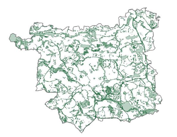
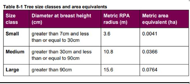
Policy area maps
The following maps form part of the Schedule of Changes for our Local Plan Update pre-submission changes consultation:
Policy EN3 - Solar Energy Opportunity Area 3
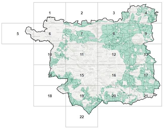
List of Solar Energy Opportunity Area maps
- Solar Energy Opportunity Area 3 - 1
- Solar Energy Opportunity Area 3 - 2
- Solar Energy Opportunity Area 3 - 3
- Solar Energy Opportunity Area 3 - 4
- Solar Energy Opportunity Area 3 - 5
- Solar Energy Opportunity Area 3 - 6
- Solar Energy Opportunity Area 3 - 7
- Solar Energy Opportunity Area 3 - 8
- Solar Energy Opportunity Area 3 - 9
- Solar Energy Opportunity Area 3 - 10
- Solar Energy Opportunity Area 3 - 11
- Solar Energy Opportunity Area 3 - 12
- Solar Energy Opportunity Area 3 - 13
- Solar Energy Opportunity Area 3 - 14
- Solar Energy Opportunity Area 3 - 15
- Solar Energy Opportunity Area 3 - 16
- Solar Energy Opportunity Area 3 - 17
- Solar Energy Opportunity Area 3 - 18
- Solar Energy Opportunity Area 3 - 19
- Solar Energy Opportunity Area 3 - 20
- Solar Energy Opportunity Area 3 - 21
- Solar Energy Opportunity Area 3 - 22
Policy EN3 - Wind Energy Opportunity Area 3
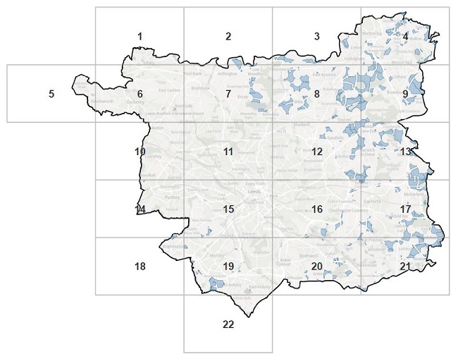
List of Wind Energy Opportunity Area maps
- Wind Energy Opportunity Area 3 - 1
- Wind Energy Opportunity Area 3 - 2
- Wind Energy Opportunity Area 3 - 3
- Wind Energy Opportunity Area 3 - 4
- Wind Energy Opportunity Area 3 - 5
- Wind Energy Opportunity Area 3 - 6
- Wind Energy Opportunity Area 3 - 7
- Wind Energy Opportunity Area 3 - 8
- Wind Energy Opportunity Area 3 - 9
- Wind Energy Opportunity Area 3 - 10
- Wind Energy Opportunity Area 3 - 11
- Wind Energy Opportunity Area 3 - 12
- Wind Energy Opportunity Area 3 - 13
- Wind Energy Opportunity Area 3 - 14
- Wind Energy Opportunity Area 3 - 15
- Wind Energy Opportunity Area 3 - 16
- Wind Energy Opportunity Area 3 - 17
- Wind Energy Opportunity Area 3 - 18
- Wind Energy Opportunity Area 3 - 19
- Wind Energy Opportunity Area 3 - 20
- Wind Energy Opportunity Area 3 - 21
- Wind Energy Opportunity Area 3 - 22
Policy G2C - Long Established Woodland
List of Long Established Woodland Area maps
- Long Established Woodland area map 1
- Long Established Woodland area map 2
- Long Established Woodland area map 3
- Long Established Woodland area map 4
- Long Established Woodland area map 5
- Long Established Woodland area map 6
- Long Established Woodland area map 7
- Long Established Woodland area map 8
- Long Established Woodland area map 9
- Long Established Woodland area map 10
- Long Established Woodland area map 11
- Long Established Woodland area map 12
- Long Established Woodland area map 13
- Long Established Woodland area map 14
- Long Established Woodland area map 15
- Long Established Woodland area map 16
- Long Established Woodland area map 17
- Long Established Woodland area map 18
- Long Established Woodland area map 19
- Long Established Woodland area map 20
- Long Established Woodland area map 21
- Long Established Woodland area map 22
Policy G8B - Leeds Habitat Network
List of Leeds Habitat Network Area maps
- Leeds Habitat Network Area map 1
- Leeds Habitat Network Area map 2
- Leeds Habitat Network Area map 3
- Leeds Habitat Network Area map 4
- Leeds Habitat Network Area map 5
- Leeds Habitat Network Area map 6
- Leeds Habitat Network Area map 7
- Leeds Habitat Network Area map 8
- Leeds Habitat Network Area map 9
- Leeds Habitat Network Area map 10
- Leeds Habitat Network Area map 11
- Leeds Habitat Network Area map 12
- Leeds Habitat Network Area map 13
- Leeds Habitat Network Area map 14
- Leeds Habitat Network Area map 15
- Leeds Habitat Network Area map 16
- Leeds Habitat Network Area map 17
- Leeds Habitat Network Area map 18
- Leeds Habitat Network Area map 19
- Leeds Habitat Network Area map 20
- Leeds Habitat Network Area map 21
- Leeds Habitat Network Area map 22
Policy SP13 - Strategic Green & Blue Infrastructure Network
List of Strategic Green & Blue Infrastructure Network Area maps
- Strategic Green & Blue Infrastructure Network Area map 1
- Strategic Green & Blue Infrastructure Network Area map 2
- Strategic Green & Blue Infrastructure Network Area map 3
- Strategic Green & Blue Infrastructure Network Area map 4
- Strategic Green & Blue Infrastructure Network Area map 5
- Strategic Green & Blue Infrastructure Network Area map 6
- Strategic Green & Blue Infrastructure Network Area map 7
- Strategic Green & Blue Infrastructure Network Area map 8
- Strategic Green & Blue Infrastructure Network Area map 9
- Strategic Green & Blue Infrastructure Network Area map 10
- Strategic Green & Blue Infrastructure Network Area map 11
- Strategic Green & Blue Infrastructure Network Area map 12
- Strategic Green & Blue Infrastructure Network Area map 13
- Strategic Green & Blue Infrastructure Network Area map 14
- Strategic Green & Blue Infrastructure Network Area map 15
- Strategic Green & Blue Infrastructure Network Area map 16
- Strategic Green & Blue Infrastructure Network Area map 17
- Strategic Green & Blue Infrastructure Network Area map 18
- Strategic Green & Blue Infrastructure Network Area map 19
- Strategic Green & Blue Infrastructure Network Area map 20
- Strategic Green & Blue Infrastructure Network Area map 21
- Strategic Green & Blue Infrastructure Network Area map 22