A printable PDF version of the document is available at the end of the page.
Explanatory note: This document sets out the policies and supporting text which make up the Local Plan Update 1 Publication Draft. As these policies will have the effect of amending and updating the existing Core Strategy (2019 as amended) and the Natural Resources and Waste Local Plan 2013 (Minerals Transport policies 2015), the document specifies which parts of the adopted Core Strategy and Natural Resources and Waste Local Plan are proposed to be amended.
The document is split into 8 sections:
- Overall Approach
- Carbon Reduction
- Flood Risk
- Green and Blue Infrastructure
- Place Making
- Sustainable Infrastructure
- Amended Glossary
- Schedule of Superseded Policies
- Policy area maps
Overall approach
Insert the following into page 3 "Updating the Core Strategy" section after iv as follows:
v. In response to the City Council's declaration of a Climate Emergency in 2019, the pressing need for the Metropolitan District to stay within its legally binding carbon budget and to prepare for the effects of Climate Change upon people, places and the natural environment, a Local Plan Update DPD is prepared with the following objectives:
- Carbon reduction: For new development, Leeds will seek to minimise energy demand and meet all demands for heat and power without increasing carbon emissions, to allow Leeds to meet its climate emergency commitment of zero carbon by 2030.
- Flood Risk: Leeds will ensure that new developments are located and designed to avoid, reduce and mitigate flood risk, increase biodiversity and reduce the carbon footprint of risk reduction schemes through natural flood solutions.
- Green & Blue Infrastructure and Biodiversity: Leeds will create new Green and Blue Infrastructure (GBI) (including Green Space and Natural Environment) through the planning process, and identify, improve, protect and extend existing GBI to address the challenges of climate change and create a healthy city.
- Place-making: Leeds will work in the public interest, prioritising the safety and well-being of people within a framework of long-term sustainable development by allowing development that promotes safe, healthy and resilient places, reflects the issues associated with inclusive growth and an environment which leaves a positive legacy for all people.
- Sustainable Infrastructure: Leeds will ensure the delivery of an accessible and integrated transport system which focuses on public transport and active travel, is worthy of its role at the heart of the Leeds City Region and supports communities and inclusive growth.
To meet these objectives the Local Plan Update focusses on the following selected areas of policy, which will have a plan period of 2022 to 2040 and incorporates the following policies into the Core Strategy:
- An overarching climate change mitigation and adaptation policy at new Policy SP0
- Carbon Reduction policies, which replace policies EN1, EN2, EN3 and amend Policy EN4 in SP0, updated Policy SP1, revised EN1, EN2, EN3, EN4 and a new EN9
- Flood Risk policies, which replace Natural Resources and Waste Local Plan (NRWLP) Policies with Policies Water 1, Water 2, Water 3, Water 4, Water 5, Water 7; amend NRWP Policy Water 6; and create new Policy Water 6a and Water 8
- Green and Blue Infrastructure policies, which replace Policies SP13, G1 and G6; amend Policy G4 and introduce new Policies G4A, G4B, F1, G8A, G8B, G2A, G2B and G2C in SP13, GS1,
- Place making policies which introduce new Policies SP1A, SP1B, EN9 and P10A; replace Policy P10 and amend Policy SP1.
- Sustainable Infrastructure, which introduces new Policies SP11A, SP11B and DC1.
Amend para 1.8 of the Core Strategy as indicated by words in italics:
What is the Core Strategy Trying to Achieve?
1.8 The Core Strategy plans for the longer term regeneration and growth of the District over a 16 year period, as part of an overall and integrated framework. Central to this approach is the need to give priority to sustainable development in planning for economic prosperity, seeking to remove social inequality, securing opportunities for regeneration, and planning for infrastructure, whilst maintaining and protecting and enhancing environmental quality for the people of Leeds. Underpinning these broad objectives and supported by the Core Strategy evidence base, is the desire to respond to the Council's declared Climate Emergency and make rapid progress towards Leeds being carbon neutral by 2030 at the same time as responding to the need for the District to be resilient to the effects of Climate Change alongside current and emerging population pressures and associated needs across the District, especially within inner urban areas. Key priorities therefore include: planning for the provision of homes and jobs in sustainable locations, respecting local character and distinctiveness in the delivery of the Plan's objectives and maximising opportunities to recycle previously developed land (PDL), whilst minimising greenfield and Green Belt release, in planning for longer term growth.
Insert the following after new text after para 1.18:
1.19 Tackling climate change through mitigation contributes to the zero carbon pillar of the Best Council Ambition. The Council's overall plan is to:
- reduce the Council's carbon footprint
- reduce pollution and noise
- reduce the level of greenhouse gas emissions from buildings in the city
- promote cycling, walking and the use of public transport
- promote a less wasteful, low carbon economy
- reduce flooding and other risks from the impact of climate change
- build sustainable infrastructure
- to help residents reduce their own carbon footprints
1.20 The Council also has a Climate Adaptation and Resilience Plan (2022) which endorses the Climate Change Committee's (CCC) principles of adaptation to climate change including:
- integrating adaptation into other policies
- assessing interdependencies
- addressing inequalities
- considering opportunities
- preparing for unpredictable extremes
- adapting to 2°C warming and assessing the risks for 4°C warming
Amend para 2.42 as indicated by the words in italics:
Key Challenges
2.42 Leeds is a large and diverse City, with a proud heritage, a quality environment and home to a wide range of communities and businesses. As outlined above there are major opportunities for growth and regeneration and a desire for this to be achieved and managed in a way, which reflects the unique character of the District and the principles of sustainable development. In the preparation of the Core Strategy therefore there are a number of key challenges the overall spatial vision, development strategy and policy framework are seeking to meet. These include:
- Mitigating climate change and adapting to it effects upon people, places and the natural environment
- Planning for population growth and the complex needs of a diverse population, (including opportunities to improve public health),
- Facilitating local opportunities for urban regeneration and economic growth, within the context of major changes and uncertainty in the national and international economy,
- Planning for housing growth in a sustainable way in suitable locations, whilst meeting a range of housing needs,
- Ensuring that opportunities for regeneration and economic growth support the aspirations of the community in delivering needed jobs and homes,
- Ensuring that the physical development and growth of the District, is managed in a sustainable way, to respect the local identity, character and distinctiveness of communities and delivers high quality design and environment enhancement,
- Opportunities for regeneration and growth are supported with the necessary infrastructure,
- The need to maintain and develop, a longer term partnership approach to development and growth within the District, with a range of stakeholders including communities, investors and infrastructure providers
Amend para 3.2 as indicated by the words in italics:
3.2 The long term vision for the Leeds Metropolitan District is that by 2028 (and by 2040 for those policies amended and introduced as part of the Local Plan Update):
A) Leeds will have maintained and strengthened its position at the heart of the City Region and has grown a strong diverse and successful urban and rural economy, with skilled people and competitive businesses, which are sustainable, innovative, creative and entrepreneurial. All communities will have equal chances to access jobs and training opportunities through the growth of local businesses.
B) Leeds City Centre will remain a successful destination for the people of Leeds and beyond, with a vibrant commercial, leisure and cultural offer. The Trinity and Victoria Gate centres will be well established and the South Bank will be integrated into the City Centre, which includes a new City Centre Park acting as a gateway to the Aire Valley.
C) The spatial distribution of growth will be planned and delivered to balance the use of brownfield and greenfield land in a sustainable way, as part of an overall framework promoting development in suitable locations as a basis to meet identified needs.
D) The distinctive settlement pattern within the Leeds District will be maintained and its character enhanced, whilst providing for and supporting new housing growth opportunities. The main urban area of Leeds will support the diverse and distinctive communities that surround it, separated by agricultural land, woodland, valuable green spaces, habitats, and amenity areas.
E) Town and local centres will remain at the heart of their communities and provide a good range of shopping, services and local facilities.
F) Aire Valley will become an innovative new living and working community, supported by the necessary community facilities and infrastructure, which is a national model for sustainable development, accommodating a minimum of 6500 new homes and 35,000 new jobs within a distinctive green environment. An integral part of the Urban Eco-Settlement will be the establishment of low carbon solutions, and energy requirements in established communities will have been significantly reduced by retrofitting.
G) The Regeneration Priority Programme Areas will have undergone successful transformations, in terms of having more attractive environments, improved choice and quality of housing, better access to employment through improved education and training, and increased connectivity to adjoining neighbourhoods, including the City Centre.
H) In reflecting the role of Leeds as a strategic transport hub (including Leeds City Station and Leeds Bradford International Airport), serving existing communities and in planning for new growth, sustainable forms of development are delivered (which include public transport as an integral part). Consistent with the ambitions to be 'the Best City in the UK', Leeds will be better connected, by an accessible and integrated transport system, which supports communities and economic competitiveness.
I) Leeds will have a wide network of multi-functional Green and Blue Infrastructure (including green space areas) which provides an improved quality of life for residents to enjoy healthier lifestyles and ensure the resilience of biodiversity. This will also be a strong incentive in attracting new business to the area. Through new development, opportunities will be taken to improve connections between Green and Blue Infrastructure to enhance its value and achieve a better spatial distribution.
J) Leeds will work within its Carbon Budget and will have made rapid progress towards carbon neutrality by 2030.
K) Leeds will be resilient to climate change through the use of innovative techniques and efficient use of natural resources.
L) Place making will be embedded into the planning process which has led to the creation, protection, and enhancement of buildings, places and spaces that are valued by people. This will have a positive contribution towards better public health and wellbeing, especially in communities where there have been clear health disparities and disadvantage.
Amend para 3.3. objectives as indicated by words in bold italics and strikethrough:
(v) Managing Environmental Resources and Responding to the Climate Emergency:
In safeguarding the environment of the District, the Core Strategy needs to:
17. Protect natural habitats and enhance biodiversity through Biodiversity Net Gain, the creation of new habitats and by improving and extending wildlife corridors.
18. Secure development which has regard to its impact on the local environment and is resilient to the consequences of climate change, including flood risk, air quality, health, overheating and drought.
19. Promote net zero carbon and energy efficient heat and power, for both new and existing development.
20. Make efficient use of natural resources, including the implementation of sustainable design and construction techniques, whole life cycle carbon emission considerations, the prudent use of minerals, and the effective minimisation and management of waste.
21. Protect and enhance Green and Blue Infrastructure, strategic green corridors, green space, and areas of important landscape character, taking the opportunity to improve their quality, connectivity and accessibility through the development process.
[Insert the following section after 4. Spatial Development Strategy and before 4.1 Overview and Location of Development]
4.0 Planning for Climate Change
4.0.1 Section 19 of the 2004 Planning and Compulsory Purchase Act, as amended by Section 182 of the Planning Act 2008, states: "Development plan documents must (taken as a whole) include policies designed to secure that the development and use of land in the local planning authority's area contribute to the mitigation of, and adaptation to, climate change." Through the Climate Change Act 2008 and as a signatory of the Paris Agreement, the UK Government has committed to:
M) reduce emissions by at least 100% of 1990 levels by 2050; and
N) contribute to global emissions reductions aimed at limiting global temperature rise to well below 2°C and to pursue efforts to limit temperatures to 1.5°C above pre-industrial levels.
4.0.2 To meet these targets, the UK Government sets legally binding five-yearly carbon budgets i.e. the amount of greenhouse gases the UK is permitted to emit for each 5-year period. The Climate Change Committee's (CCC) Sixth Carbon Budget, introduced into law in 2021, sets a target to reduce UK greenhouse gas emissions by 78% by 2035 (compared with 1990 levels). Meeting the Sixth Carbon Budget enables the UK to deliver on its contribution to the Paris Agreement and requires the UK to reduce emissions by 2.25% of 1990 levels per year. In its 2021 Net Zero Strategy: Build Back Greener the UK Government sets out policies and proposals for decarbonising all sectors of the UK economy to meet a net zero target by 2050 with a roadmap set out below. However, the CCC has found that the Government's policies and plans are not enough to meet carbon budgets and that the policy gap has widened.
| Emissions reductions | UK Government |
| 2025 | 55% |
| 2030 | 68% |
| 2035 | 78% |
| 2045 | - |
| 2050 | 100% |
4.0.3 Within this legal framework and national policy context ambitious targets have been established at the local level In Leeds because the evidence supports that. Yorkshire and Humber's share of the 'carbon budget' to 2050 on a per capita basis is estimated at circa 250 mega tonnes. As the greatest generator of carbon in the region and the centre of the Leeds City Region, the District has a responsibility to lead by example. If the District continues business as usual its carbon budget to 2050 will have been used up by 2029. The United Nations Intergovernmental Panel on Climate Change (UNIPCC) has warned that the opportunity to limit world temperatures to under 1.5°C and avoid the worst climate change impacts will vanish in the next decade so action change is required immediately. Against this clear evidential driver for change it is noted that climate-related events are continuing to affect the District in frequency and severity e.g. the frequency of storms, such as Storm Eva, the floods over Christmas 2015 and the drought of 2022.
4.0.4 The Leeds Climate Commission and City Council have worked to clarify what efforts are needed to reduce carbon locally to remain within budget. The initial focus is on Scope 1 and 2 carbon emissions generated within Leeds (i.e. the fuel and electricity directly used within the District boundary). These are the emissions which are of most relevance to the planning system and the grant of planning permission. Scope 3 emissions - concern consumption and personal choices (e.g. owning a pet, buying lots of clothes with a high carbon footprint as well as long distance travel). In Leeds Scope 1 and 2 emissions have fallen by 40% since 2000. With on-going decarbonisation of grid electricity and considering population and economic growth within the city region, it is projected that the District's 2000 level of annual emissions will have fallen by a total of 45% in 2030 and 49% in 2050. If it is to stay within its carbon budget, the District needs to add to the emissions reductions already achieved to secure significant further reductions. The Leeds Climate Commission Roadmap follows the Government's roadmap of aiming for net zero by 2050 but recognises on the basis of the IPCCC evidence that further reductions are needed sooner.
| Emissions reductions | Leeds Climate Commission |
| 2025 | 70% |
| 2030 | 85% |
| 2035 | 95% |
| 2045 | 97% |
| 2050 | 100% |
4.0.5 The Leeds Climate Commission demonstrates that it is technically and economically possible for Leeds to become a carbon neutral city and to meet ambitious carbon reduction targets in line with the global targets set out by the United Nations. The roadmap makes clear that no single innovation will resolve the climate crisis or put the District on the right path to zero carbon but that a combination of activities is essential. This means that no-one and no sector can afford to not play their part or to leave it to someone else to make the efforts.
4.0.6 In 2020, 38% of Leeds' emissions came from the transport sector, with housing responsible for 26% of emissions, public and commercial buildings for 21% and industry 15%. The Leeds Climate Commission's analysis includes assessment of the potential contribution of energy saving or low carbon measures for: households, public and commercial buildings (including better insulation, improved heating, more efficient appliances, small scale renewables), transport (including more walking and cycling and enhanced public transport) and industry (including better lighting, improved process efficiencies and a wide range of other energy efficiency measures).
4.0.7 The roadmap to net zero for Leeds also involves considerations of the existing built stock within the District and it has been estimated that to retrofit the 350,000 homes to net zero standards alone would cost circa £5bn. This is not something that the planning system can have a significant influence on as retrofitting does not require the grant of planning permission, however it is a relevant consideration. It places significant weight on new development to be designed and constructed to net zero standards now. This is for three reasons. First, so as to not worsen the baseline against which net zero ambitions are measured i.e. for every carbon emitting new building there will need to be additional efforts added to an already challenging route to net zero. Second, so as to avoid adding to the District's retrofit bill in the future. Third, supporting the continued development of the green and low carbon economy now to assist in the longer term journey. The significant retrofit challenge in the District also creates a justification for considering ways in which new development can help support wider retrofit programmes via planning obligations as noted in Policy EN1.
4.0.8 To that end, the Council declared a Climate Emergency in 2019 which acknowledges the Leeds Climate Commission's Roadmap and sets ambitions to make significant progress to being net zero carbon by 2030. The Council has also established a Best City Ambition in 2021 which has 3 pillars: Health and wellbeing, Inclusive growth and Zero carbon. The City Ambition states that "in 2030 Leeds will have made rapid progress towards carbon neutrality, reducing our impact on the planet and doing so in a fair way which improves standards of living in all the city's communities". it notes that it will focus on:
- delivering a low-carbon and affordable transport network which encourages people to be physically active and reduces reliance on the private car, helping people get around the city easily and safely
- promoting a fair and sustainable food system in which more produce is grown locally, and everyone can enjoy a healthy diet
- addressing the challenges of housing quality and affordability, tackling fuel poverty and creating vibrant places where residents have close access to services and amenities
- joining with local communities, landowners and partners to protect nature and enhance habitats for wildlife
- investing in our public spaces, green and blue infrastructure to enable faster transition to a green economy while improving quality of life for residents.
4.0.9 Within that ambition the Council has embarked on a significant number of projects to ensure that its own operations and estate are net zero carbon by 2030 and expects new developments to achieve 100% net zero carbon reductions by that date. It is important that new development does that because if the District continued to only deliver 85% carbon reductions from new development up until 2030 then the challenge would be exacerbated by worsening the carbon that already exists in the current baseline.
4.0.10 In carrying out its Section 19 Statutory duties and working within its legally binding carbon budget the Council proposes that several planning policies play a fundamental role in supporting the Leeds carbon roadmap by:
- shaping places in ways that contribute to radical reductions in greenhouse gas emissions, e.g. by reducing the need to travel by car
- encouraging more prudent use of existing resources e.g. by making homes and businesses more efficient in their use of materials and their operation and encouraging the re-use of buildings rather than demolition. This is to promote retention of materials in use at their highest value for as long as possible and then reused or recycled, leaving a minimum of residual waste, also known as 'The Circular Economy'
- supporting the move towards renewable and low carbon energy and associated infrastructure e.g. by identifying where wind farms and solar farms have the potential to be located
- minimising vulnerability and improving resilience e.g. by avoiding places that flood and dealing with water as well as preparing for hotter summers and helping the natural world adjust
- taking opportunities to sequester carbon from the atmosphere e.g. through trees and other Green and Blue Infrastructure
4.0.11 Policy SP0 is an overarching strategic policy, which takes on board the Council's legal duties and the work of the Leeds Climate Commission in identifying the planning priorities for action on climate change and relevant adaptation measures, as well as encompassing a carbon reduction budget for which planning plays a fundamental contributory role. The policy identifies that climate change is a cross-cutting theme for the Core Strategy that involves many policies and actions operating together at the same time.
4.0.12 Policy SP0 is primarily focussed on reducing Scope 1 and 2 operational carbon emissions but also sets ambitious objectives for consideration of Scope 3 emissions particularly as these relate to the Whole Life Cycle carbon emissions of building materials and construction practices and in creating sustainable places that encourage people to be more conscious of the carbon footprint.
4.0.13 In ensuring the successful implementation of this policy and its subsequent detailed policies in the Core Strategy, the Council will support developers with new and revised Supplementary Planning Documents, checklists, and standardised assessment methodologies so as to ensure that these necessary policy objectives can be easily delivered. In so doing the Council will monitor the implementation of these policies by reference to per capita carbon dioxide emissions with a target of carbon neutrality by 2030.
Strategic Policy SP0: Climate Change Mitigation and Adaptation
Development must contribute to the reduction of carbon emissions in Leeds.
New developments will achieve 100% net zero operational carbon reductions (on 2000 levels) to help make significant progress to the District being net zero by 2030.
New developments will support the District's wider science-based Scope 1 and 2 carbon reduction targets (on 2000 levels) as follows:
- 85% by 2030
- 95% by 2035
- 97% by 2040
- 99% by 2045
- 100% by 2050
This will be achieved by:
- Minimising carbon emissions, including by:
- Adapting to the impacts of climate change, including by:
- Ensuring resilient and healthy places, including by:
- Maximising carbon storage and sequestration, including by:
- Supporting the robustness of the District's biodiversity, including by:
a. Developing in sustainable locations in accordance with Policy SP1 and SP1A
b. Supporting the city centre, town and local centres as sustainable hubs in accordance with Policies SP2, P2, P3 and P8
c. Supporting the delivery of 20-minute neighbourhoods which arecomplete, compact and connectedwalkable and cyclable (wheelable)places in accordance with Policy SP1A
d. Building zero carbon operational buildings in accordance with Policies EN1
e. Improving the sustainability of buildings in accordance with Policy EN2
f. Taking opportunities to incorporate Whole Life Cycle carbon emissions into buildings in accordance with Policy EN1
g. Taking opportunities to incorporate and connect to renewable and low carbon sources of heat and power in accordance with Policies EN1, EN2 and EN4
h. Promoting the generation of renewable energy within the District in accordance with Policy EN3
i. Reducing the need to travel by car and encouraging sustainable travel in accordance with Policy SP1, SP11, EN9, T1, T2 and MINERALS 13
j. Delivering densities that make the most of accessible sites in accordance with Policy H3
k. Incorporating electric vehicles charging points in accordance with Policy EN8
l. Encouraging more food growing in the District so as to reduce food miles in accordance with Policy F1.
l.m. Promoting the circular economy by prioritising the retention of existing structures rather than demolition'.
a. Restricting inappropriate development in high flood risk areas and managing flood risk in association with Policies EN5 and WATER 3, 4, 5, 6 and 7
b. Delivering net gains for biodiversity that help support plants and animals adjust to changing climates in accordance with Policy G9
c. Incorporating water and energy efficiency measures into the active and passive design of new buildings in accordance with EN2 and WATER 1
d. Providing Green and Blue Infrastructure and Green Spaces which provide shade, reduce overheating and mitigate air pollution in urban areas in accordance with Policies G1 and G4B
a. Promoting the creation and growth of 20 minute neighbourhoodscomplete, compact and connected places where the reliance on the private car is reduced and social interaction and health and well-being are maximised, in accordance with Policy SP1A
b. Making best use of land, including in the inner city which is more vulnerable to a changing climate, to ensure that it can perform carbon adaptation roles such as laying out of Green Space and protecting trees in accordance with Policy G2A
c. Improving the design of places, in accordance with Policy P10
d. Improving the health and well-being of residents of Leeds, in accordance with Policy P10A.
a. Protecting, enhancing and extending Green and Blue Infrastructure that helps sequester carbon in accordance with Policies SP13 and G1
b. Protecting habitats that fulfil carbon storage functions in accordance with Policy G8
c. Protecting and planting trees and recognising their essential role for carbon sequestration as well as amenity and ecology, in accordance with Policies G2A and G2C.
a. Protecting, enhancing and extending Green and Blue Infrastructure that helps create places, corridors and stepping stones for nature in accordance with Policies SP13 and G1
b. Identifying opportunities to create more biodiverse developments in accordance with Policy G9 and SP1B
c. Protecting important habitats from development and harm in accordance with Policy G8
d. Seeking biodiversity net gain from all relevant development in accordance with Policy G9
e. Protecting and planting trees, in accordance with Policies G2DC.
Carbon Reduction Policies
The following section replaces 5.5.31 to 5.5.53 of the Core Strategy
Carbon Reduction Draft Policy
As of 2020, 26% of the District's emissions come from housing whilst public and commercial buildings account for 21%. Whilst the Council, property owners and partners are making efforts to retrofit existing buildings there is a need for new buildings to stop adding to these emissions. The Leeds Climate Commission identifies a need to reduce the District's carbon footprint by reducing carbon emissions from:
- fuel (e.g. gas)
- electricity
- goods produced elsewhere but imported within the area
As part of meeting the Climate Emergency and responding to the science-based targets set out in Policy SP0, new development has a fundamental role to play in reducing its carbon footprint through these means. Developments should focus on reducing both their total carbon emissions through carrying out Whole Life Cycle Assessments and their operational energy.
Whole Life Cycle Carbon Assessments
Whole life cycle (WLC) carbon emissions result from the materials, construction and the use of a building over its entire life, including its demolition and disposal. As operational carbon emissions are reduced by requirements in national building regulations and Leeds Local Plan policies, the comparative importance of embodied carbon as an element of whole lifecycle carbon emissions becomes more crucial. The term embodied carbon takes account of the emissions associated with the materials and construction processes throughout the whole life cycle of a building or infrastructure and can represent around 50% of total emissions over a building's lifetime. There is currently no national policy that requires calculation of a development's whole life cycle carbon emissions, however, if the District is to meet its zero carbon ambitions and understand where further action on reductions are needed, then the whole life cycle carbon emissions will have to be accounted for.
Principles for whole life cycle carbon emissions assessment of the environmental impacts from built projects are underpinned by British Standard BS EN 15978 methodology. This defines a standard building's life expectancy as 60 years and breaks down the life cycle into five overall stages (illustrated by Table 'LPU 1' below) of a standard construction project where embodied emissions should be assessed.
Table 'LPU 1': Elements of whole life cycle emissions as defined by BS EN 15978, with module in [brackets]
| Life cycle stage | Description of emissions activity in life cycle stage | Embodied or Operational emissions |
| Product stage [A1-A3] | Carbon emissions from raw materials and manufacturing processes | Embodied |
| Construction stage [A4-A5] | Construction activity including transport to site | Embodied |
| Use stage [B1-B7] | Repair and refurbishment during use [B1-B5] stage | Embodied |
| | Operational / in-use emissions including heating and hot water etc. [B6-B7] | Operational |
| End of life stage [C1-C4] | De-construction, removal, waste processing etc. | Embodied |
| Beyond life stage [D] | Impacts and benefits from reuse, recovery and recycling of materials and products | Embodied |
Whilst providing assessments may be a relatively new requirement for the development industry, taking a WLC approach from the outset is likely to realise potential cost savings through:
- Promoting recovery and reuse of existing structures over demolition and new construction.
- Designing to use less construction material from the outset of a development project
- Construction methods (such as modular construction) which can deliver embodied carbon savings and higher levels of efficiency
Policy EN1 Part A requires applications for new major development to acknowledge the carbon costs of a development over its entire lifetime and address ways in which it will reduce them. Whilst, applications for minor development will have a cumulative life cycle impact across the District, the Policy requires such development to provide information only on how the scheme has considered the Council's bespoke embodied carbon checklist so as not place unreasonable burdens on small scale developments. The policy does not require applications to meet a kgCO2e/m2 target, however evidence from the assessments will be collected and used to set targets through future plan review. Therefore, this approach creates a transitional period, which allows all parts of the building industry time to become familiar with the methodology behind the assessment.
Where the policy requires applications to demonstrate actions to reduce life-cycle carbon emissions of the development, applicants will be expected to provide examples of measures taken, prior to RIBA stage 7, which have resulted in reductions of the embodied carbon of the development.
Applications would be expected to use a nationally recognised tool for submitting their WLC assessments, and at the time of preparation of the Local Plan Update the following tools are advocated:
- One Click LCA, which includes collaborations with RICS, the GLA and the UKGBC to provide a variety of tools
- UKGBC One Click Planetary tool covers A1-A5 of the RICs methodology and can be used for free to assess the embodied carbon of key construction materials
- Leeds City Council whole lifecycle carbon assessment checklist for minor applications
Whole life cycle carbon assessments will be monitored and this policy will be subject to a future plan review to set a benchmark figure for future development to achieve.
Where an application is seeking to demolish an existing building, then the applicant will have to demonstrate that the new development would have a lower carbon cost over its lifetime through the calculation of its embodied carbon and projected operational carbon emissions when measured against reusing the existing building(s). If the building is currently not in use, or in a state of disrepair, an estimation of its energy demand for the proposed use should be provided by the applicant.
Existing buildings contain significant amounts of embodied carbon that can be lost through demolition. In order for applications to consider whether demolition is necessary, and if it is, how those existing materials can be reused or recycled through a new development, Policy EN1A Part B requires applicants to demonstrate how existing buildings may not be suitable for the proposed development and how materials should be recycled and reused if demolition is necessary. Where materials cannot be reused or recycled, justification for this should be submitted through the application.Justification for why demolition of buildings may be required include:
- The buildings are unsafe, or contain hazardous materials
- The buildings do not support the proposed use, in terms of layout or size.
- The proposed development willsignificantly improve energy efficiency, resulting in long term carbon savings and lower costs of operation for the occupiers.
EN1 Part A: Embodied Carbon
A. All major development should calculate their whole life cycle carbon emissions using a nationally recognised assessment methodology and demonstrate actions to reduce life-cycle carbon emissions of the development.
B. All applications to demolish a building will need to demonstrate how the replacement development will be more energy efficient and use less carbon over its lifetime than reusing the existing building. Buildings should be reused. Where an application is seeking to demolish a building, the applicant must demonstrate why the proposed use is not suitable for the existing buildings on site. Once it has been established that the existing building is not suitable for the proposed use, applications will need to demonstrate how they will reuse and recycle materials created through the demolition. Evidence will be required where applicants believe that materials cannot be reused or recycled.
C. Minor and household applications should consider the whole life cycle emissions of the development and make reasonable efforts to reduce those emissions using natural and recycled materials in the construction process. This should be demonstrated by assessing the scheme against the Council's whole life cycle carbon assessment checklist for minor and household applications.
Whole life cycle carbon assessments will be monitored and this policy will be subject to a future plan review to set a benchmark figure for future development to achieve.
Operational Energy
Operational carbon targets for new development are currently set by Building Regulations. The District's previous Policy EN1 (2014) required new major developments to go beyond Part L of the Building Regulations, however evidence suggests that this will no longer support Leeds meeting its net zero targets.
Building regulations include fabric efficiency standards such as maximum heat loss through walls, windows etc. (U values), as well as the type of heating system it is expected that buildings will use. Building regulations relate the predicted carbon emissions from a building to the heating system through the Standard Assessment Procedure (SAP) which must be used to calculate building performance. However Part L does not calculate unregulated energy and is not an appropriate method to calculate predictedbuilding energy use performance accurately. Therefore Policy EN1B will focus on energy based metrics and require applications to calculate their predictive energy demands using modelling toolsapplicants to calculate the predicted energy demands (space heating demand and Energy Use Intensity targets) of the development using modelling tools.
In line with the Policy SP0, Policy EN1 Part B requires new development to be operationally net zero by 2030. It is important to note that building regulations requirements and calculation methodology include regulated emissions only (made up of primary building services like heating, cooling and lighting). The total operational energy and carbon emissions from a development also include unregulated emissions (including computer equipment, fridges, washing machines, TVs, computers, lifts, and cooking, etc) which can comprise up to 50% of a building's total operational energy. Therefore, in order to be operationally net zero (regulated and unregulated), a development's energy needs will need to be met through renewable energy, be that through onsite andor offsite generation with financial contributions as a last resort.
As the national grid decarbonises, operational carbon emissions may become less useful over time in assessing the quality of developments in terms of energy efficiency and demand reduction. Other measures of building performance during operational phase become more important. EUIEnergy Use Intensity (EUI) targets which describe a buildings operational energy demand (unregulated and regulated) targets on a maximum kWh/m2/year basis are one way of addressing this. EUI targets can be assessed at design stage through the planning process, as well as measured as-built and in-use to support monitoring and help address any performance gap. Such targets will require a focus on fabric efficiency of buildings. This is important as it future proofs the built stock of the District and will help avoid expensive retrofit in future years. This is further justified as reduced energy needs will lower the costs of heat and power for the occupiers/end users.
In addition to fabric efficiency, developers should consider passive design principles for new development including:
- Building orientation, layout and optimised shading to maximise winter heat gain and minimise summer overheating.
- High levels of thermal insulation and air tightness to reduce heat demand.
- Passive ventilation and cooling e.g. through optimised glazed area and associated solar gain, and use of natural ventilation in summer
- Hot water demand reduced e.g. by limiting shower flow rates.
New development will be expected to be 'fossil fuel free'. A significant carbon emitter of new properties is the installation of a gas boiler. The inclusion of a gas boiler would make it impossible to deliver a net zero operational energy development and for national and local decarbonisation targets, any gas boilers installed now will have to be replaced with a net zero compatible heating technology in the future. This will cause disruption and expense to the future owner or resident. Therefore, no gas boilers will be permitted within new development. Moreover, direct electric resistive heating is not supported as it is inefficient when compared to other heating sources (such as heat pumps) and can result in higher energy consumption and therefore higher energy bills for occupiers. Fossil fuel plants onsite may be seen as acceptable where:
- There are emergency and life safety issues, such as providing back up power in the healthcare sector or other emergency uses.
- There is a requirement for energy back up to essential functions in buildings and sites defined of critical importance.
In order to comply with implement Policy EN1B planning applications will be supported by energy statements (pre and post construction) that demonstrate how the development meets a net zero operational carbonenergy balance. These will include calculations for annual & cumulative carbon emissions for 30 years. This can be done using an approved building modelling software such as IES VE, SBEM and PHPP depending on the type of development, the outputs of which must be included in the planning application. To reflect the changing grid carbon intensity, developers should employ the official UK government's expected electricity grid carbon intensity figures rather than the static carbon factors inherent in 2021 Building Regulations / SAP methodology.
Up until the end of the transition period on 31st December 2026, applications will have to demonstrate how they have maximised fabric efficiency and onsite renewable energy generation with an aim to meet the transitional EUI and Space Heating Demand targets found within the policy. The Council understands that the heating technologies, supply chains and skill base may not currently be at the required national level to deliver all buildings in all locationsto the standards detailed in the policy. However, this is a fast moving area and the development industry has told the council that it is committed to net zero so there is a need for a transition approach. In, in the interim, justification should be provided for why the requirements cannot be met. Once the transition period is complete by the endof 2026, applications will be expected to achieve a net zero operational energy balance by meeting the EUI's and Space Heating Demand within the policy and could be refused planning permission if not met.
Where applications submitted after the 1st January 2027 a development that cannot technically or feasibly be delivered to net zero operational energy balance standard, then a carbon offsetting financial contribution would be sought. Examples where a scheme may not be technically feasible may be where:
- Site constraints resulting in a lack of potential for on-site renewable energy generation equal to the buildings operational energy. This is most likely in high density schemes where the available roof space to deliver Photo Volataic (PV) panels would not generate enough energy for the gross internal floorspace delivered.
- Historic buildings where energycarbon saving measures may create unacceptable damage or loss to the building's historic character.
In such circumstances robust justification for not achieving an operational net zero carbon energy balance will be required which balances the need for the development against its additional carbon emissions that will conflict with Policy SP0.
The £/tonne of carbon commuted sum in which the Council will levy to developers is based on the best available science on the true cost of carbon, and on established practice. The UK Government provides an official £/tonne of carbon emissions which should be taken into account and as of 2022, the cost of carbon is set at £248/tonne, and this will increase to £280/tonne by 2030. The contributions in lieu will be used to deliver Council run projects that help reduce carbon across the district.
Following the end of the transition period in 2026, applications that cannot generate the renewable energy demand of the development onsite will be expected to financially offset the residual energy requirement. The offset value will be calculated using the following methodology:
Shortfall between annual energy and renewable energy generation onsite (kWh/m2) X cost of PV installation offset figure
The financial offset multiplier is linked to the Government's solar photovoltaic cost dataset and the cost per kW for 10-50 kW installations. The Council will provide an annual update of the offsetting value to reflect any amendments to the Government's cost dataset with. As of September 2023, the offset price would be £1.35/kWh/yr, although this figure will have been updated upon adoption of offsetting in 2027.
Financial contributions collected through offsetting will go towards renewable energy generation installations and projects to improve energy efficiency.These will include:
- Upgrading and retrofitting of existing housing stock
- Generating and supporting renewable and low carbon energy and heat projects
- Energy projects for community buildings
- Carbon sequestration projects (including tree planting)
The above projects are not exhaustive, and liable to change as the Council continues to support and introduce new carbon reducing projects. The annual sum of offset contributions receivedcommuted sums collected will be monitored through the AMR, which will also detail the projects that receive financial assistance through this mechanism.
EN1 Part B: Operational Energy
All new development must demonstrate that the buildings will achieve net zero operational carbon emissions in line with the following hierarchy:
Minimise carbon emissions through passive design principles including fabric efficiency measures.
Following carbon minimisation in Step 1, include renewable energy onsite to deliver an annual net zero carbon balance (including regulated and unregulated emissions)
Exceptionally and subject to a demonstration of technical or feasibility constraints, all remaining operational carbon for a 30-year timeframe should be offset through a £248/tonne financial contribution to the Council to deliver carbon savings locally. This will increase to £280/tonne by 2030.
Gas boilers and direct electric resistive heating will not be supported.
Planning applications need to be supported by energy statements (pre and post construction) that demonstrate how the development meets net zero operational carbon
An energy statement at the planning application stage will be required to demonstrate how energy efficient design and demand reduction measures meet the following Energy Use Intensity targets:
| Development Type | Energy Use Intensity Target | Space Heating Demand |
| Housing | 35 kWh/m2/year | 15 kWh/m2/year |
| Commercial Offices | 55 kWh/m2/year | 15 kWh/m2/year |
| Schools | 65 kWh/m2/year | 15 kWh/m2/year |
| Offices | 55 kWh/m2/year | 15 kWh/m2/year |
| Multi-residential (student accommodation etc) | 35 kWh/m2/year | 15 kWh/m2/year |
| Retail | 55 kWh/m2/year | 15 kWh/m2/year |
| Leisure | 100 kWh/m2/year | 15 kWh/m2/year |
| Research Facility | 150 kWh/m2/year | 15 kWh/m2/year |
| Higher education teaching facilities | 55 kWh/m2/year | 15 kWh/m2/year |
| Light industrial uses | 110 kWh/m2/year | 15 kWh/m2/year |
| GP Surgery | 55 kWh/m2/year | 15 kWh/m2/year |
| Hotel | 55 kWh/m2/year | 15 kWh/m2/year |
A post construction energy statement will be required before occupation.
Up to the
31st
of
December
2026, all new development must:
- Minimise energy demand through passive design principles including fabric efficiency measures,
- Maximise renewable energy onsite to attempt to deliver an annual net zero energy balance (including regulated and unregulated emissions) and
-
Ensure on-site plant (e.g. heating, cooking, generator) are fossil fuel free, with the exceptions of emergency uses and uses where backup energy generation is deemed essential
.
In order to achieve the above, applications will meet the following
Transitional
Energy Use Intensity (EUI)
and Space Heating Demand targets:
| Development Type | Energy Use Intensity Target (kWh/m2/year) | Space Heating Demand (kWh/m2/year) |
| Housing (including student accommodation) | 40 | 30 |
| Commercial (Offices, retail, hotels, education) | 75 | 30 |
| Leisure | 100 | 30 |
| Industrial | 110 | 30 |
| Research Facility | 150 | 30 |
Where the above standards
are not
met, applicants will be expected to demonstrate
the technical or policy factors
that cause
non-compliance, including evidence
as to how they have maximised attempts to meet the target EUI and space heating demand figures.
Planning applications need to be supported by energy statements (pre and post construction) that will also demonstrate how the development seeks to maximise renewable energy opportunities onsite.
From January 2027, all new development must demonstrate how
it will achieve a net zero operational energy balance. In order to achieve this, developments will
use the following hierarchy:
- Minimise energy demand through passive design principles including fabric efficiency measure,
- Maximise renewable energy onsite to and attempt to deliver an annual net zero energy balance (including regulated and unregulated emissions),
-
Ensure
on-site plant (e.g. heating, cooking, generator)
are fossil fuel free, with the exceptions of emergency uses and uses where backup energy generation is deemed essential. -
Subject to a demonstration of technical or
policy constraints, provide offsite financial contribution to deliver the remaining energy imbalance off site.
In order to achieve the above, applications will have to meet the following Net Zero Operational EUI
and Space Heating Demand
targets:
| Development Type | Energy Use Intensity Target (kWh/m2/year) | Space Heating Demand (kWh/m2/year) |
| Housing (including student accommodation) | 35 | 15 |
| Commercial (Offices, retail, hotels, education) | 55 | 15 |
| Leisure | 100 | 15 |
| Industrial | 110 | 15 |
| Research Facility | 150 | 15 |
Planning applications need to be supported by energy statements (pre and post construction) that demonstrate how the development
delivers a net zero operational
energy balance.
Developments that will be exempt from this policy are:
The above requirements will not apply to:
1. Buildings exempt from building regulations
2. Alterations and extensions to buildings of up to 1,000 square metres
3. Change of use or conversion of buildings
4.3. Ancillary buildings that stand alone and cover an area less than 50 square metres
5.4 Buildings which have an intended life of less than two years
6.5 Gypsy and Traveller and Showpeople
pitches
and plots caravans
For all such exceptions development must show how efforts to reduce carbon emissions have been considered, in accordance with current good practice.
Sustainable Construction Standards
Carbon savings sit within a number of building improvements that help new development mitigate and adapt to climate change, reduce demand for and pressure on natural resources as well as save occupants money on utility bills. A home or workplace built to such standards also encourages its occupants to reduce their carbon footprints in other ways.
To ensure that new development within Leeds is delivered to a high quality design standard, new major development will be expected to meet either Home Quality Mark Level 4 or BREEAM
Excellent Outstanding.
The Home Quality Mark (HQM) certification scheme from BRE awards a 1-5 star rating for new homes against a set of criteria which include living costs, health and wellbeing and environmental footprint. Indicators include reducing energy and carbon emissions, improving biodiversity, home security and recreational space, flood risk, internal noise, and temperature. Promotion of public or active travel options and access to local amenities would support reductions in household carbon emissions outside of the scope of the buildings themselves. Credits can be obtained from a range of indicators within three indicator bands - 'my costs', 'my wellbeing' and 'my footprint'. A minimum number of credits must be achieved in each to obtain a 1-5 star rating.
The HQM involves a two-stage assessment to ensure principles are incorporated at design stage and to verify the standard has been met post-construction. Assessment is undertaken by independent assessors, trained and licensed by BRE. Applicants will be expected to deliver a design stage report as part of their application and will be required (by condition) to provide a post-construction assessment once the development has been delivered. At both stages, the reports will have to have been independently assessed by an accredited assessor.
BREEAM New Construction 2018 is the UK version of BRE's international sustainable building standard for non-domestic buildings. This includes commercial, office, retail, education, healthcare, and public buildings, as well as short and long stay residential institutional buildings such as hotels, care homes, and sheltered accommodation etc., and can include part new-build, part refurbishment projects.
Assessment and certification must be carried out by a licensed BREEAM Assessor and includes a range of evidence and site inspection. The criteria include reducing energy and carbon emissions, sustainable materials and construction practices, health and wellbeing of building users, accessibility and sustainable transport options.
Non-domestic buildings are expected to deliver
at least an 'Outstanding'Excellent rating
and those with an Outstanding rating will be encouraged and supported. This should ensure the delivery of very high-quality non-residential developments which reduce their environmental impact and provide a much better environment for those working within them. Again, applicants will be expected to deliver a design stage report as part of their application and will be required (by condition) to provide a post-construction assessment once the development has been delivered. At both stages, the reports must be independently assessed by an accredited assessor.
There are other sustainable construction standards and targets that applications can achieve as of 2022, these include the Passivhaus Standard, Living Building Challenge and RIBA 2030 targets. Whilst the Council will support applications meeting these standards, they may not include a holistic approach to sustainable design that the Home Quality Mark and BREEAM assessments require. If it can be demonstrated that compliance with another construction standard meets the outputs required by a BREEAM/HQM assessment, then consideration will be given to that when determining compliance with Policy EN2.
[Amend policy EN2 of the Core Strategy as indicated by the words in bold italics]
EN2: Sustainable Construction Standards
Part A: Standards
To ensure the delivery of high-quality new development, and assist in a holistic approach to sustainable construction as set out in EN1, SP1B, and P10, major applications should demonstrate how they meet one of the following construction standards:
- Non-residential development will conform to a minimum rating of BREEAM OutstandingExcellent and those with an Outstanding rating will be encouraged and supported.
- New-build residential developments must achieve a minimum four-star rating (as a minimum) under the BRE Home Quality Mark scheme.
To evidence the above, applications will include independently certified evidence of their sustainability credentials at the design stage and post construction.
Heat District Network
Development Within Heat Network Zones
Leeds City Council and its partners Vital Energi are constructing a heat network, via underground pipes, around Leeds City Centre which re-uses the heat produced from the Recycling and Energy Recovery Facility (RERF) to supply a low carbon form of heat in the urban area to local homes and businesses. The network already has several connections, and Policy EN4 requires new development to connect when appropriate.
Heat networks are systems in which heating, cooling or hot water is generated at a central source and supplied to multiple users through a pipe network serving either multiple buildings (district heat network) or multiple occupants in a single building (communal heat network). They offer particular advantages in dense urban areas where many users can be supplied with low carbon heat from the same source or sources, using the shared infrastructure. They are an important part of the solution for heating decarbonisation.
The UK Government recognises that heat networks will play a key role in the transition to net zero. Because they are able to connect multiple users to shared heat source/s, heat networks can make use of abundant renewable energy which would otherwise be wasted or not viable for exploitation. Non-fossil fuel sources for heat networks can include:
- Rivers and other surface water sources
- Subsurface water sources such as abandoned mine workings and aquifers
- Shallow geothermal heat
- Buried infrastructure such as building foundations, tunnels, and wastewater networks
- Deep geothermal
- Waste heat from other sources such as industrial sites or data centres, for example
The UK Government is developing policies to designate heat network zones across England by 2025. This forms a key part of the Government's strategy to increase heat network deployment and achieve net zero. A heat network zone is defined as, "a designated area within which heat networks are the lowest cost, low carbon solution for decarbonising heating for an area". In practice, zoning proposals will mean heat networks are likely to grow outwards from city centres with their large non-domestic heat demands.
Primary legislation will be required to implement the proposals, and the consultation documents suggest the preferred option would be that within a heat network zone, "all new builds, large non-domestic, large public sector and communally heated residential blocks would be required to connect to heat networks". All options under consideration will require new developments within heat network zones to connect to a heat network.
Development Outside of Heat Network Zones
For development outside of heat network zones or any site where connection to a heat network is not mandatory under future legislation, flexibility is offered in order to allow developers to take the most appropriate approach for their application. Developers should aim to install heating technology that provides the lowest cost and lowest carbon. In order for developers to deliver a low cost and low carbon heating technology, they should assess.
1. Annual carbon emissions each year for 30 years, using the government's official electricity grid carbon intensity factors.
2. Annual running costs for occupants each year for 30 years, using the government's official retail fuel costs.
Both (1) and (2) are available from HM Treasury Green Book Supplementary Guidance and are updated regularly. The most up-to-date figures should be used.
[Amend policy EN4 of the Core Strategy as indicated by the words in bold italics]
EN4: District Heating
Up until any revised district heat network national policy is introduced, where technically viable, appropriate for the development, and in areas with sufficient existing or potential heat density, developments of 1,000 sqm or more or 10 dwellings or more (including conversions where feasible) should propose heating systems according to the following hierarchy:
- Connection to existing District heating networks,
- Construction of a site wide District heating network served by a new low carbon heat source,
- Collaboration with neighbouring development sites or existing heat loads/sources to develop a viable shared District heating network,
- In areas where District heating is currently not viable, but there is potential for future District heating networks, all development proposals will need to demonstrate how sites have been designed to allow for connection to a future District heating network.
Carbon savings and renewable energy generation achieved under this policy will contribute to EN1(A) and EN1(B).
For development situated outside heating network zones, or where it has been evidenced that it is not technically feasible to connect to a heat network, then the following heating technologies should be considered instead:
- Air source heat pumps
- Ground source heat pumps
- Shared ground heat exchanges
- Water source heat pumps
Preference should be given to the heat technology that finds a balance between delivering the lowest cost for future inhabitants and lowest carbon emissions over its lifetime.
All heat network applications will need to demonstrate that potential impacts on nationally and internationally designated sites have been assessed and mitigation provided where appropriate.
Renewable Energy
Leeds has the potential to generate renewable energy from a number of sources, such as anaerobic digestion, biomass, heat pumps, hydro, onshore wind and solar. To help ensure the UK has a secure energy supply, reduce carbon emissions from the generation of energy and promote investment in new green jobs and the industry, it is important to support the delivery of new renewable and low carbon energy infrastructure by supporting development in the most appropriate locations. The NPPF requires that plans should provide a positive strategy for renewable energy, that maximises the potential for suitable development whilst ensuring that adverse impacts are addressed satisfactorily (including the cumulative landscape and visual impacts). The Local Plan and any subsequent planning decisions will need to balance the generation of renewable and low carbon energy with the need to protect Leeds' environment, communities and businesses from any adverse impacts associated with development.
The Council has identified the potential to generate a total of 2,290 MW of renewable energy through solar and wind power across the district:
-
90 MW of wind -
2,200 MW of solar
These are high estimations, that
consider a cumulative
delivery of all land identified suitable for wind and solar energy,
subject to further planning considerations.
It is acknowledged that not all potential land identified
to deliver renewable energy generation will do so.
Policy EN3 is relevant to all standalone renewable and low carbon energy generation development, and its associated infrastructure (such as energy storage). The Council's opportunity area mapping and select criteria are only relevant to solar and wind generation, with a general policy covering other potential renewable energy development. Supportive text below will give further details to consider when determining renewable energy generation applications not directly referred to within the main policy.
This mapping is relevant to the development of multiple turbines and solar farms rather than stand alone turbines and solar panels arrays on rooftops, which would be acceptable throughout the District in line with National Guidance.
Indeed the Council supports small-scale, community-based wind turbine applications which are local led across all parts of Leeds.
Planning permissions associated with renewable and low carbon energy developments are typically temporary, which reflects their limited lifespan. Planning conditions will be used to control the length of time that operations are permitted on site and to provide a decommissioning plan that would return the land to its original state.
Wind and Solar Opportunity Areas
The opportunity area mapping for solar and wind takes account of:
- Flood risk,
- Proximity to housing,
- Best and most versatile agricultural land, including impacts on farms and agricultural tenancies,
- Registered parks and gardens,
- Landscape character,
- Highway, public rights of way & trainline impacts,
- Archaeology, scheduled monuments, and registered battlefields,
- Listed buildings and heritage impacts,
- Green infrastructure
- Areas of bird sensitivity particularly at Fairburn and Mickletown Ings,
-
The South Pennine Moors Special Protection Area and the functionally linked land that supports it - Tree preservation orders and aAncient wWoodland,
- Proximity of sensitive receptors to noise and vibration,
- Future developments – Leeds City Council's allocation plans,
- HS2 safeguarding areas,
- Airport and airbase operational areas
and
Aerodrome Safeguarding Area.
The evidence provided areas of opportunity that focussed on 3 types of land: brownfield land only, all land excluding Green Belt and all land including Green Belt. The result of the mapping demonstrates that there is not enough land within brownfield and non-Green Belt areas within the District to deliver large scale solar and wind energy generation schemes, and therefore it is expected that future developments are likely to fall within the Green Belt. Applications in the Green Belt will be required to demonstrate Very Special Circumstances as required by national policy guidance, however the fact that they are located in an opportunity area for renewable energy will be a material consideration in their favour. Applications which fall outside of the opportunity areas are unlikely to be acceptable.
The NPPF footnote 54 advises that proposed wind energy developments involving one or more turbines should demonstrate that planning impacts identified by an affected local community have been fully addressed and the proposal has their backing. Therefore, early engagement with local communities is essential and planning proposals will need to demonstrate how planning impacts have been assessed objectively and considered with local communities. Planning Practice Guidance is clear that whether a proposal has community backing is a planning judgement for the local planning authority to take. In arriving at this judgement, the Council will consider the balance of views from the local community, including relevant Town and Parish Councils, and how the application has overcome these or not, through objective evidence and assessment and whether there is majority support. The Council will in the planning application report, set out how it has reached its conclusion and the extent to which it considers there is local community backing.
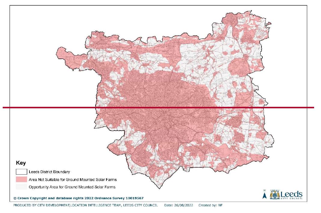
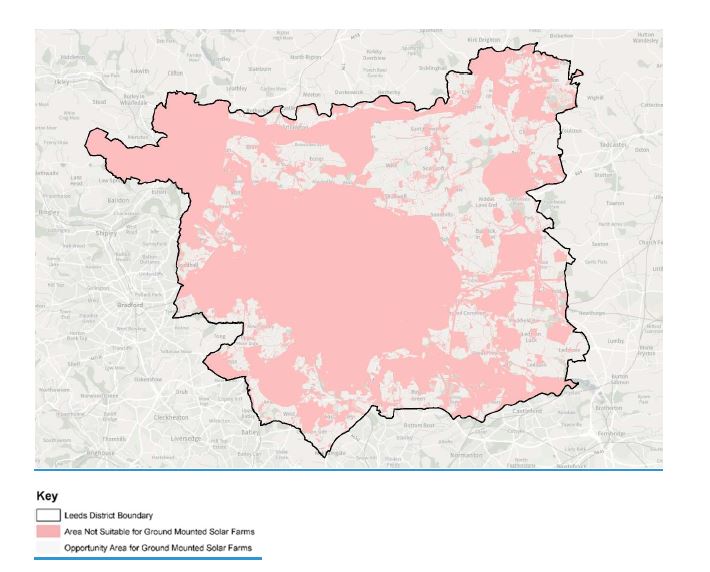
Solar Opportunity Areas
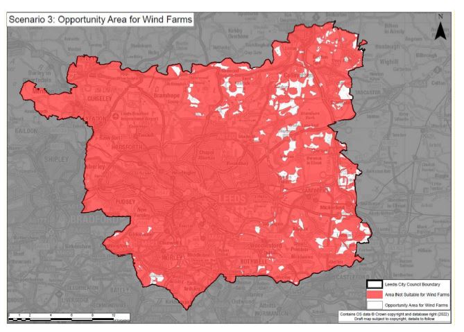
Wind Opportunity Areas
Hydro Electric
The British Hydropower Association recommends that:
- A hydro-electric system should not increase risk of flood damage from a watercourse. It must be demonstrated that the net effect of any raising of levels in the watercourse or impoundment and diverting water from existing flows does not significantly increase the potential risk of flooding surrounding land or property.
- The proposed scheme arrangement should not adversely affect other water users, such as livestock farmers, fish farms, water sports clubs, water companies. Mitigation measures should be agreed for continued use or compensation agreed.
- Land habitat of protected species should not be damaged. In areas which are likely or known to provide support for protected species, a qualified walk over survey should be conducted to determine the population and to confirm no significant impacts will be caused by construction or operation of the hydro scheme. Any identified breeding or dwelling sites should be avoided during construction.
- Hydro schemes should not create electrical risk. Their installation and servicing should meet current standards. Where grid connected a connection offer must be agreed with the relevant DNO.
- Where there are penstocks these should be buried if feasible and otherwise made safe.
- Powerhouse structures and design should attenuate the noise levels of the turbine and generator to acceptable levels 1m away from the building in populated or frequented area. Turbine houses should be fitted with appropriate levels of sound insulation and close-fitting doors as necessary.
- Turbine houses should not be unsightly if in urban areas or places of natural beauty; they should be constructed using materials appropriate to the environment. Heritage or otherwise controlled areas should not be affected, or consents should be obtained. All neighbouring property owners must be notified and not opposed to the scheme.
A hydro-electric system should not risk significant damage to the fish population in the river basin. Mitigation measures include:
- Screen the entry of water at the abstraction point and the outflow to restrict access to the turbine.
- Limit the disturbance of water and waterbed at the turbine outflow.
- Ensure an environmental flow ('compensation flow') and supplementary 'residual flows' which will provide sufficient riverbed coverage and flow, to sustain important habitat and food resource.
- Where there is significant use by fish (judged by qualified walk over survey) and any weir reconstruction or new structures exceeding the height of natural obstacles, provide suitable alternative fish passage up and down the watercourse; and protect fish spawning habitat such as weir pools against potentially adverse changes in flow.
Mitigate adverse changes in sedimentation resulting from impoundment changes by mechanical means.
Anaerobic Digestion & Energy from Waste
Anaerobic Digestion (AD) and Energy from Waste (EfW) plants can be considered to be similar in some ways; the principal similarity is that they are both industrial processes that process waste and produce energy. These processes have a role to play in the wider energy system, however their use should not disincentivise more sustainable alternatives (prevention of waste production, re-use of items/materials and recycling).
For EfW, Energy from Waste, the proposed plant should not undermine the supply of waste to other pre-existing EfW plants except in cases where this is demonstrably helpful to the wider national waste strategy. Applications for anaerobic digestion/energy from waste should consider the following:
- Negative impacts of the transport of feedstock to the AD/EfW plant.
- Air emissions from the proposed plant
- The potential to produce both heat and electricity for use elsewhere. Electricity can be supplied into the national grid and heat can be supplied to other buildings through district heat networks. Plants should be designed and located to facilitate the export of both heat and electricity (this can be based upon either existing or new developments or a mixture of the two)
- Proximity to residential buildings. A minimum separation distance of 100m and 50m is expected for EfW and AD plant respectively.
- Resilience to drought, especially where river water is to be used for cooling. Where the project is likely to have effects on water quality or resources the applicant should undertake an assessment and demonstrate that appropriate measures will be put in place to avoid or minimise adverse impacts of abstraction and discharge of cooling water.
- Carbon Capture Ready (CCR) and/or have Carbon Capture and Storage (CCS) technology applied.
- Green belt locations will generally be considered to be inappropriate development. Careful consideration must therefore be given to the visual impact of projects. Developers will need to demonstrate very special circumstances that clearly outweigh any harm by reason of inappropriateness and any other harm if projects are to proceed.
- Noise assessment of the impacts on amenity.
- Assessment and mitigation of the risk of insect infestation with particular regard to the handling and storage of waste for fuel.
Biomass
Biomass is plant-based material used as fuel to produce heat and/or electricity. Biomass may be produced as a by-product of an industrial or agricultural process or grown and harvested specifically for use as a fuel. Biomass fuel can be used as a source of heat for buildings or industrial processes or as a fuel for electricity generation.
Burning biomass (wood, straw, grass etc.) releases carbon dioxide (CO2). Biomass can be considered to be a renewable energy source on the basis that the CO2 released during burning was relatively recently absorbed by the plant whilst it was growing and may be reabsorbed if another plant is growing in its place. However, further CO2 emissions are caused by the harvesting, processing and transportation of the biomass. In some cases, there may be emissions associated with the growth of the biomass crop if fertiliser, pesticide, or irrigation is used. These secondary emissions mean that, in many cases biomass is classed as low carbon rather than zero carbon.
Where applications for biomass use are submitted, the following criteria will be used:
- Taking account of the time it will take for CO2 to be reabsorbed by replacement plants/trees, the proposed use of biomass should align with the need to reduce atmospheric CO2 concentrations in the next decade in line with UN and UK targets. Where short rotation biomass crops are to be used, it should be demonstrated that the production of these will not displace food production. This analysis should account for the emissions across the complete biomass fuel supply chain, i.e. harvesting/supply – treatment/ drying/ chipping/palletisation and energy conversion efficiency.
- The biomass fuel should be transported to the site using low carbon vehicles or the distance should be limited to no more than 30 miles.
- The impact of increased vehicle movements should be adequately considered and mitigated
- The local air quality impacts of the biomass fuel combustion (and associated vehicle movements) should be mitigated.
- Proposals should demonstrate good design in respect of landscape and visual amenity.
- Proposals should consider the plant's resilience to drought, especially where river water is to be used for cooling. Where the project is likely to have effects on water quality or resources the applicant should undertake an assessment and demonstrate that appropriate measures will be put in place to avoid or minimise adverse impacts of abstraction and discharge of cooling water. Where applicable, the design of the cooling system should locate intakes and outfalls to avoid or minimise adverse impacts. There should be specific measures to minimise fish impingement and/or entrainment and the discharge of excessive heat to receiving waters.
- Proposals should be Carbon Capture Ready (CCR) and/or have Carbon Capture and Storage (CCS) technology applied.
- Proposals located in greenbelt will generally be considered to be an inappropriate development. Careful consideration must therefore be given to the visual impact of projects. Developers will need to demonstrate very special circumstances that clearly outweigh any harm by reason of inappropriateness and any other harm if projects are to proceed.
- Proposals should include a noise assessment of the impacts on amenity. The primary mitigation for noise for biomass power plants is through good design to enclose plant and machinery in noise-reducing buildings, wherever possible, and to minimise the potential for operations to create noise. Noise from turbines should be mitigated by attenuation of exhausts to reduce any risk of low-frequency noise transmission.
Treatment of residues (primarily biomass ash) should be demonstrated to be compatible with local and national waste and environmental policies.
Energy Storage
Leeds has identified the potential need for 2,500MWh of energy storage in Leeds. Electricity storage infrastructure would help to increase the self-sufficiency of Leeds' energy supply and to balance the national supply and demand of electricity. The increased use of distributed and intermittent electricity generation (such as wind and solar PV) has also increased the need for the types of grid support services that battery parks can provide.
- Firm Frequency Response: National Grid pays operators of batteries and other power plant equipment to provide sub-second responses to help smooth and correct fluctuations in grid frequency.
- Balancing Mechanism: National Grid pays operators of batteries and other power plant equipment to supply capacity to the grid operator at agreed times to help it balance network supply and demand.
- Capacity Market contracts: National Grid pays operators of batteries and other power plant equipment to respond when there is a high risk that a system stress event could occur. This happens very rarely but the payments are typically awarded simply for being available to provide the service for a period even if it is not needed/used. Battery systems are typically located in one of the following three places:
- Co-located with wind or solar PV farms: This can allow developers to install PV or wind capacity which exceeds the capacity of the grid connection and to provide power at times when electricity prices are high rather than when the renewable plant is generating (which is dependent on the weather).
- Close to electrical substations and grid supply points: To directly provide grid support services. When connected to grid supply points (which link the national transmission network to the local distribution network) these might be considered to be providing national-level grid support.
Within the premises of a large electricity user: This is typically done where security of electricity supply is particularly important or where the electricity demand fluctuates over a large range. This type of installation may not require planning permission if it is within an existing building
Evidence within the Renewable Energy Study suggests that Leeds has the potential, assuming an extensive build-out of the following technologies, to generate:
- Energy from waste (EfW) plants: 360,000 MWh/yr
- Anaerobic digestion CHP plants: 3,060 MWh/yr
- Hydro-electric plants: 2,260 MWh/yr
- Solar PV farms: 2,000,000 MWh/yr
- Wind farms: 380,000 MWh/yr
Figure 'LPU 2' Renewable Energy Potential in Leeds
If the energy above was to be delivered within Leeds, then modelled scenarios detailed within the Study suggests that the use of battery systems at a city-scale may be cost effective up to a limit of around 2,500MWh. However, there is potential use for a further 3,500MWh or longer-term storage.
EN3: Renewable Energy
The Council has identified the potential to generate a total of 2,290 MW of renewable energy through solar and wind power across the district:
90 MW of wind
2,200 MW of solar
This policy identifies aAreas potentially suitable for
wind and solar renewable energy, and
these are identified on the
Wind and Solar Energy Opportunities Maps.policies map. Within these areas, renewable energy and its associated infrastructure will be supported subject to the
following policy criteria: relevant policy criteria and all other relevant national and local policy being met.
Wind
Applications for wind energy development involving one or more turbines will not be considered acceptable unless within an area identified as suitable for wind energy developmentas identified by this policy and shown on the wind opportunities map
or as part of a locally led community renewable scheme. Applications in those areas must
satisfy the following requirements:. Applications should demonstrate that:
1. Any impacts of the proposal on the local community
(including affected communities in adjacent districts) have, through early consultation, been identified and mitigated;
2. The proposal, both individually and cumulatively with other renewable energy developments, does not cause significant harm to the quality and enjoyment of the existing landscape;
3. The proposal would not result in unacceptable harm on amenity, taking into account noise, shadow flicker, vibration, topple distance, air traffic safety and radar;
4. The proposal has no unacceptable impact on high voltage overhead pylons;
5. The proposal has no impact on the migration routes of important bird species;
6. Provision has been made for the satisfactory decommissioning of the turbines and associated infrastructure once the operations have ceased and the site can be restored to a quality of at least its original condition and
7. Very Special Circumstances
will need to be demonstrated for Green Belt release if
applications they are in areas of the District covered by Green Belt
7.8.
Any
potential impacts on nationally and internationally designated sites have been assessed and mitigation provided where appropriate.
Applications that are seeking to repower or extend the life of existing turbines, including those that fall outside of an opportunity area, will be supported where any potential impacts can be made acceptable.
Solar
Applications for ground mounted solar energy and any associated infrastructure will not be considered acceptable unless within an area identified as suitable for solar energy development as identified by this policy and shown on the solar opportunities map will be supported in principle
subject to
meeting
the following requirements:
Applications should consider the impact on the following criteria:
- Landscape
- Agricultural Land
- Visual amenity
- Noise
- Safety and security
- Ecology
- Conservation and built environment and
- the energy generating potential,
- If the proposal involves greenfield land, then it should allow for continued agricultural use and encourage biodiversity improvements around arrays
- The proposal should ensure that there is no negative impact caused by glint and glare on the landscape, neighbouring uses and aircraft safety.
- Ensure that there are no negative impacts if solar arrays follow the daily movement of the sun
- Well designed security measures such as lights and fencing
-
If within the setting
of
heritage
assets, great care should be taken to ensure that they are conserved in a manner appropriate to their significance, including the impact of proposals on views important to their setting. - The potential to mitigate landscape and visual impacts through, for example, screening with native hedges
- TApplications will need to demonstrate that potential impacts on nationally and internationally designated sites have been assessed and mitigation provided where appropriate
Proposals that fall partially within the opportunity area and meet the above criteria, may also be supported if it can be demonstrated that no harm is caused by
the development.
Applications for roof mounted solar panels will be supported across the district, where it can be demonstrated that no harm is caused by the installation.
Other and Micro Generation
Applications for other renewable energy development,including hydro-electric, anaerobic digestion/energy from waste and its associated infrastructureincluding
small scale wind and solar, will have to demonstrate that its impacts on the following are (or can be made) acceptable:
- Landscape
- Visual and audio/acoustic amenity
- Safety
- Ecology; and
- Conservation and built environment
Energy Storage
Leeds has identified the potential need for 2,500MWh of energy storage in Leeds.
Energy storage developments will be supported in principle where:
- it is related to an existing or proposed renewable energy development,
or:
- It can demonstrate how the development alleviates grid constraints.
Applications must meet the following criteria:
a) Any proposed development which will contain large quantities of batteries should include adequate mitigation measures such that ePprovide adequate mitigationd
for
explosion and fire risks are acceptable;
b) Proposed development should have a noise impact assessment carried out and;
c) Proposed battery parks should:
a.
b)
Mitigate any adverse vVisual impactsseek to mitigate their visual impacts with the use of hard and soft landscaping and use of appropriate external materials;
b.
c)be supported by Aa noise assessment
will be required
and . If there are relevant noise receptors the development should incorporate suitable noise attenuation measures such that noise impacts to nearby sensitive receptors are suitably mitigated.
a. d)
Should not be located in flood zone 3 unless the Sequential and Exceptions tests can be passed and should be designed and constructed to remain operational and safe in times of flood and do not will not increase the risk of flooding or other associated risks to other developments, infrastructure, natural habitats or farmland.
a.
b. e)
Ddemonstrate that potential impacts on nationally and internationally designated sites have been assessed and mitigation provided where appropriate.
Flood Risk Policies
Flood Risk
[The following policies will be inserted into the Core Strategy (2019) after new policy 'EN9 under the title 'Flood Risk'. They shall result in the deletion of policies Water 1, Water 2, Water 3, Water 4, Water 5 and Water 7 from the NRW Plan. A footnote shall be added after existing policy EN5: 'Managing Flood Risk' to signpost to this new section.]
Water Efficiency
Water is a basic necessity and household and commercial demand from new development is a component of Yorkshire Water's demand forecast for its Water Resources Management Plan 2019 (WRMP). The WRMP projects that remedying leakage will be the key means of ensuring that demand for water does not outstrip supply and that water deficits before the mid-2030s are unlikely. However, with increasing impacts of climate change, including more frequent and severe droughts and hosepipe bans, coupled with significant growth within the District, there is a role for new development to play in making efficient use of water now. Policy EN2 requires that development follows the Quality Home Quality Mark standard which includes provision of water-efficient fittings and water recycling systems. Further detailed information on ways to ensure water efficiency and water quality improvements are found in the Council's Sustainable Design and Construction Supplementary Planning Document 2010. Additionally, developers are encouraged to refer to the Environment Agency's Water Resources Strategy which sets out how water resources should be managed to 2050 and identifies areas where action is required. To that end, all major residential development is expected to meet the tighter optional water standard in building regulations as required by Policy Water 1.
Water 1: Water Efficiency
All new developments should include measures to improve their overall water efficiency where appropriate. This will be achieved through a mixture of measures to use less treated water and reduce wastewater such as:
- Sustainable urban drainage systems,
- Rainwater collection and storage,
- Grey water recycling and storage systems, and
- More absorbent surfaces for water drainage.
All rResidential developments of 10 or more dwellings (including conversion) where feasible) are required to meet a water standard of 110 litres per person per day.
Protection of Water Quality
Local authorities must address any targets for water quality improvements as required by the Water Environment (Water Framework Directive) (England and Wales) Regulations 2017 and as a legal duty to comply with the Humber River Basin Management Plan. This covers both surface and groundwater sources and the Environment Agency are responsible for classifying and monitoring the quality of these water sources. A list of types of activity which trigger the need for a Water Framework Assessment can be found inhttps://www.gov.uk/government/publications/water-framework-directive-how-to-assess-the-risk-of-your-activity
Research has shown that by considering the water management infrastructure (e.g. sewers, drains, pumping stations, ditches, infiltration systems and swales) as an integral part of the design a better effect on water quality is achieved.
Water 2: Protection of the Water EnvironmentWater Quality
Development within areas adjacent to sensitive water bodies, such as rivers, streams, canal, lakes and ponds, must demonstrate control of quality of surface water runoff for the lifetime of the development and during construction.
Applications for development that include a waterbody within or adjacent to the red line boundary, or that fall within 10m of a waterbody should consider Water Framework Directive impacts through the submission of a Water Framework Assessment.
For major developments the water management infrastructure should be considered as an integral part of the urban and landscape design.
[The following deletes and replaces paragraphs 6.12-6.14 and policy Water 3 of the NRW Plan and incorporates it within the new 'water and flood risk' section of the Core Strategy]
Functional Floodplain
Leeds aims to avoid locating development in flood risk areas. However, this is not always possible as a result of the city's historical growth along the Rivers Aire and Wharfe and the network of tributaries that flow into those rivers. There are already well-established communities in the city centre and other town centres along these river corridors where there is a need to focus investment and regeneration. The planning system must balance competing conflicts in enabling investment whilst having regard to the effects of climate change.
To minimise inappropriate new development in areas of higher flood risk, in line with current government guidance, the Council applies a 'sequential test'. The sequential test ensures that areas at lower risk of flooding from any source are developed in preference to those areas with a higher flood risk. The purpose is, where possible, to steer development away from the higher fluvial flood risk areas (Flood Zones 2 and 3) and areas affected by other sources of flooding. Only when there are no reasonably alternative available alternative sites in Flood Zones 1 or 2 should the suitability of sites in Flood Zone 3
or other areas of flood risk be considered, taking into account the flood risk vulnerability of the proposed land use.
For a 'more vulnerable' development land use, such as residential, in a high fluvial flood risk zone (zone 3) the development proposal will also have to pass an Exception Test. This demonstrates that the development will provide wider sustainability benefits to the community that outweigh the flood risk. The development must also be safe for its lifetime taking account of the vulnerability of its users, without increasing flood risk elsewhere, and, where possible, will reduce flood risk overall.
The functional floodplain, or flood zone 3b, includes land where water has to flow or be stored in times of
river flooding with a 1 in 30 year estimated return period (3.3% AEP – Annual Exceedance Probability)of flooding. 3.3% or greater annual probability of flooding, with any existing flood risk management infrastructure operating effectively; or
•
land that is designed to flood (such as a flood attenuation scheme), even if it would only flood in more extreme events (such as 0.1% annual probability of flooding), These areas are identified as flood zone 3b. It will also include land designed to flood in an extreme event with a 1 in 1000 year estimated return period (0.1% AEP) of flooding, such as washlands or a flood storage area designed as part of a flood alleviation scheme. The extent of the functional floodplain is defined by the Strategic Flood Risk Assessment, prepared in 2007 and updated in 2022. Most functional floodplain is open land and undeveloped. In
areas of functional floodplain these areas only water compatible uses and essential infrastructure is permitted.
The Government guidance on how to prepare an SFRA states we may
not need to designate the functional floodplain in locations where evidence shows flooding would be prevented by existing
flood defences,
flood risk management features or structures or
solid buildings. Significant reaches of the Rriver Aire in the urban conurbations of Leeds have benefitted from the construction of the Leeds Flood Alleviation Scheme. Substantial urban areas that would have otherwise flooded with a 1 in 30 year estimated return period (3.3%
or greater annual probabilityAEP) of flooding are now at a reduced risk of fluvial flooding. There are also other flood alleviation schemes in the district such as at Otley on the River Wharfe.
Within the Leeds District there are some areas within the 3.3%
annual probability of floodingAEP flood extent that are already developed and are at a reduced risk of flooding due to the presence of existing infrastructure or solid buildings acting as informal flood defence structures. Whilst these areas may be subject to frequent flooding, it is not practical to refuse all future development,. In accordance with the Planning Practice Guidance (PPG), the existing solid building footprints can be developed, where they can be demonstrated to exclude floodwater and are used for existing or a lesser vulnerable use. The land surrounding these buildings are important flow paths and flood storage areas and may also be subject to frequent flooding. Therefore, care must be given to the future sustainability of such development, ensuring there is no reduction in any flood storage capacity or interruption to flood flow conveyance, for all events up to the 1 in 100 year annual probability (1%
annual probability of flooding AEP) flood event with an allowance for climate change. For this reason, land-raising is not compatible with functional floodplain designation.
The planning policy approach to development within these areas recognises the importance of pragmatic planning solutions. The aim will be to not unnecessarily 'blight' areas of existing development as well as the importance of the undeveloped land surrounding them and the potential opportunities to reinstate areas which can operate as flood storage areas through redevelopment to provide space for floodwater and reduce risk to new and existing development.
Water 3: Functional Floodplain Zone 3b
The zone 3b
functional floodplain is shown
in the
Leeds Strategic Flood Risk Assessment. This is an area which
(i) In undeveloped areas which would naturally flood with a 1 in 30 year estimated return period (3.3% annual
probability of floodingexceedance probability) of flooding, where water has to flow or be stored in times of flood, only water compatible uses and essential infrastructure, which have passed the exception test, should be permitted. Where existing infrastructure is present in those areas or there are solid buildings acting as either formal or informal
defence structures,
(ii) In developed areas which would naturally flood with a 1 in 30 year estimated return period (3.3% annual exceedance probability) of flooding, but are prevented from doing so by existing infrastructure or solid buildings acting as either formal or informal flood defence structures, only the re-development of the existing built footprint for an existing or less vulnerable use or within an existing development plan allocation should be permitted. (providing all other policy requirements are met).
[The following deletes and replaces paragraphs 6.15-6.17 and policy Water 4 of the NRW Plan and incorporates it within the Core Strategy. Amendments to existing Water 4 are indicated by wording in bold italics]
Land at Increased Risk of Flooding
When planning for growth there is a need to consider the risk of flooding from all sources, including the consideration of the impact of climate change.
The risk of flooding to development, from all sources both now and in the future, will be managed by applying a sequential test to ensure that development is steered towards areas of lowest risk, as far as possible.
The sequential test, which seeks to direct development away from areas at risk of flooding from any source now and in the future, as far as possible, will require development proposals to be assessed against the Council's SFRA and the Environment Agency's Flood Map for Planning. The aim is to direct development to Flood Zone 1 (low probability) in the first instance, Flood Zone 2 (medium probability) in the second, then Future Flood Zone 3a and then, least preferably, Flood Zone 3a (high probability).
SitesDevelopment should not be allocated or development permitted if there are reasonably available sites appropriate for the proposed development in areas with a lower risk of flooding.
The area over which to apply the sequential test will vary depending on the type of development proposed. For example, schools have their own catchment areas, as do retail and leisure facilities. Some proposals, such as householder extensions and changes of use, are exempt from the sequential test. Applicants should contact the Council for pre-application advice on the application of the sequential test. If development cannot be directed to Flood Zone 1, the vulnerability of the proposed use(s) needs to be taken into account when assessing whether the development is suitable in the proposed location. For example, highly vulnerable uses, such as permanent residential caravans, will not be permittedare not normally considered acceptable in Flood Zone 3. Where it is necessary for 'less' or 'more' development to be located in Flood Zone 2 or 3 a sequential approach should be taken to site layout. Sites should be designed so that vulnerable uses are located on the areas of lowest risk or upper floors, which is in accordance with the recommendations of the SFRA.
The MET Office forecasts for climate change mean that Leeds needs to adopt a precautionary approach to certain types of development in high flood risk areas.
Water 4: Land at Increased Risk of Flooding
All allocations and developments are required to consider the effect of the proposed development on flood risk, both on-site and off-site the detail of which should be commensurate with the scale and impact of the development. Within
flood zones 2 and 3
as shown on the
National Flood
Map for
Planning
and in areas of
flood risk from all sourcesincluding
surface water flooding, proposals must:
(i) Pass the Sequential Test and if necessary the Exceptions Test as required by the NPPF.
(ii) In applying i) take account of the future flood zone as mapped through the SFRA climate change scenarios.
(ii) (iii) Avoid locating development in areas of flood risk bytaking a sequential approach to the layout of the site
(iii) (iv) Make space within the site for storage of flood water, the extent of which to be determined by the Flood Risk Assessment.
(iv) (v) Must not create an increase in flood risk elsewhere.
[This is an amended policy from the NRW Plan. The explanatory text shown below is unchanged from the adopted NRW Plan. The amendments to the policy are shown in bold italics]
Flood Resilience
It is important that for all development, consideration is given to flood risk. This needs to be commensurate with the degree of potential flood risk to the site and the potential impact of the development on flood risk to others. Where it is clear that there is unlikely to be any flood risk to the site and no possibility of impact on others, then a simple statement to that effect is all that is required. Where the site is in flood zone 2 or 3 and for all sites larger than 1 hectare a full Flood Risk Assessment (FRA) is required by the Environment Agency.
An FRA needs to demonstrate that the occupants can remain safe for the lifetime of the development incorporating allowances for climate change for all sources of flood risk. It should give details of the proposed flood risk mitigation up to the design flood and specified arrangements for safe access and egress. Policy WATER 6 gives an indication of the information that will be needed in an FRA however applicants are also advised to consult the Council's Strategic Flood Risk Assessment for detailed guidance on the scope of the flood risk assessment. The FRA should provide sufficient information for the development to be designed so as to mitigate the potential impact that climate change may have upon the risk of flooding over the lifetime of the proposed development as follows:
- 100 years for residential developments; and
- 75 years for commercial / industrial developments, or other time horizon specific to the non-residential use proposed.
Climate change allowances are mapped in the SFRA to help applicants design for the relevant climate change scenarios as follows:
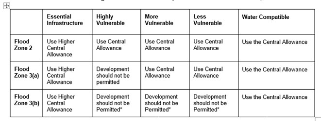
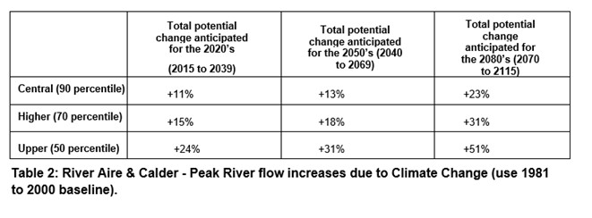
Building design should first consider passive resistance measures such as Finished Floor Levels (FFLS) which act to prevent or reduce water ingress. Following consideration of passive resistance measures, operational resistance measures, for example - flood gates, and resilience measures such as raised electrics, special construction materials and construction techniques, should be considered. This is to ensure that the development is appropriately flood resistant and resilient such that, in the event of a flood, it either remains dry, or it could be quickly brought back into use without significant refurbishment.
In assessing flood risk, including residual risks, the applicant should consider the likely duration, depth, velocities and UK flood hazard rating (FD2320) of floodwater in line with Flood Risk Assessment Guidance for New Development (FD2320).
Water 6: Flood Risk Assessments
1. All applications for new development will be required to consider flood risk, commensurate with the scale and impact of the development. Where, in the opinion of the Local Planning Authority (LPA), there is the possibility of any flood risk to the site, or the potential for flood risk impact on other sites, a Flood Risk Assessment is required.
2. The LPA is unlikely to support the development unless the Flood Risk Assessment demonstrates the following:
a. No increase in flooding on-site and elsewhere will result from the new development. The implications of climate change must be taken into account using the latest government climate change allowances.
b. There is less than a 3.33% annual probability chance of sitefluvial flooding in any one year, after allowing for the effects of climate change,
c. There is less than a 1% annual probability of fluvial flooding chance of any premises on the site flooding in any one year, after allowing for the effects of climate change, and
d. For flows beyond the 1% flood design event it is demonstrated that there are no unreasonable adverse impacts off site, after allowing for the effects of climate change.
e. Safe access and egress (see policy Water 6A for more detail).
3.
3.4. Developer contributions may be required for flood risk infrastructure improvement works (maintenance, improvement or new fluvial flood alleviation scheme or surface water drainage infrastructure) to ensure that the drainage infrastructure can cope with the capacity required to support the new development
Safe Access and Egress
[New policy and Explanatory Text]
The planning practice guidance (PPG) to the National Planning Policy Framework states that in determining whether a development is safe, the ability of residents and users to safely access and exit a building during a flood which the development is designed to withstand (or design flood), and to evacuate before an extreme flood, needs to be considered. Details of how the development will include safe access should be included in an evacuation plan. The evacuation plan should include details of whether adequate flood warnings would be available to people using the development.
Emergency planners and the emergency services should confirm the adequacy of the evacuation proposals.
The Environment Agency and the Association of Directors of Environment, Economy, Planning and Transport (ADEPT) have produced some joint guidance on flood risk emergency plans for new development. This can be found here:
https://adeptnet.org.uk/floodriskemergencyplan
The ADEPT guidance includes useful information on how to prepare an evacuation plan to ensure the proposals are safe in accordance with paragraph 167 of the NPPF and the guiding principles of the PPG.
The ADEPT Guidance notes that evacuation plans should be considered at the time the application is being considered and not be deferred for consideration at a later date through the use of a condition.
Water 6A: Safe Access and Escape
- Developments located in areas at risk of flooding, which have satisfied flood risk sequential and exception tests where relevant, must ensure residual risks are appropriately managed for the lifetime of the development and that safe access and escape is provided by the submission of an appropriate emergency plan. The emergency plan must demonstrate:
- If safe access and escape routes for people are not possible, development is unlikely to be supported other than in exceptional circumstances, depending on the vulnerability of the land use.
- In all cases, where achievable, development should aim to provide a 'dry' access and escape route located above the design flood level, including an allowance for climate change.
- The Flood Evacuation Plan shall be based on the latest available nationalEnvironment Agency guidance.
I. Safe access and escape routes are included
II. Voluntary and free movement for people will be available during a design flood taking into account climate change
III. There is potential for evacuation before a more extreme flood (0.1% annual probability of flooding AEP) taking into account climate change
IV. Appropriate evacuation procedures and flood response infrastructure will be in place
[The following deletes and replaces paragraphs 6.18-6.20 and policy Water 5 of the NRW Plan and incorporates it within the Core Strategy]
Flood Alleviation Schemes and Residual Risk
In areas where the risk of flooding is reduced because of the presence of flood alleviation schemes, proposed development will need to address the residual risks associated with a potential breach of the flood alleviation scheme or other defence. It is likely that breach modelling will be required to establish the extent of these residual risks.
These areas are shown
in
the Leeds Strategic Flood Risk Assessment (SFRA).
The area behind a defence which would be inundated with water should a defence fail during a flood is known as a zone of rapid inundation. National guidance advises that 'flood resistance and resilience measures should not be used to justify development in inappropriate locations'. There is always a residual risk that defences might fail, either by over-topping or breach, it is therefore essential that developers demonstrate that their proposals are not affected by rapid inundation in the event of breach or other failure of flood defences in any planning applications for development within those areas.
Policy Water 5: Residual Risk
- In an area which is protected by a flood alleviation scheme or other defence, development will only be permitted where it can be demonstrated that the residual risk of flooding is reduced to an acceptable level.
- A detailed breach analysis is required as part of the flood risk assessment for applications in these areas
and should consider the risk from all sources of flooding. - The NPPF sequential and exception tests must also be satisfied where relevant.
[The following deletes and replaces paragraphs 6.22-6.25 and policy Water 7 of the NRW Plan and incorporates it within the Core Strategy]
Sustainable Drainage Systems
Sustainable Drainage Systems (SuDS) should be used to reduce and manage surface water run-off to and from proposed developments as near to source as possible in accordance with the requirements of the DEFRA non-statutory technical standards for the design, maintenance and operation of sustainable drainage systems to drain surface water.
SuDS are typically softer engineering solutions inspired by natural drainage processes such as ponds and swales which manage water as close to its source as possible. The Construction Industry Research and Information Association (CIRIA) SuDS Manual supports the delivery of multiple benefits through its "four pillars" of amenity, biodiversity, water quality and flood risk management.
SuDS techniques must be designed so that they contribute to each of the four goals identified below:
- reduce flood risk (to the site and neighbouring areas),
- improve water quality,
- provide landscape and amenity benefits, and
- improve biodiversity.
Designing SuDS in this way is also more likely to help to satisfy other policy requirements such as for biodiversity net gain and health and wellbeing. The use of ponds and open water features and use of natural materials encourages biodiversity and helps to address the biodiversity emergency.
The aim should be to discharge surface water run-off as high up the following hierarchy of drainage options as reasonably practicable:
- Into the ground (infiltration)
- To a surface water body
- To a surface water sewer, highway drain, or another drainage system
- To a combined sewer
SuDS techniques can be used to reduce the rate and volume and improve the water quality of surface water discharges from sites to the receiving environment (i.e. natural watercourse or public sewer etc.). The CIRIA SuDS Manual identifies several processes that can be used to manage and control runoff from developed areas. Each option can provide opportunities for storm water control, flood risk management, water conservation, groundwater recharge and can help us to adapt and mitigate climate change and reduce our carbon footprint.
Infiltration: the soaking of water into the ground. This is the most desirable solution as it mimics the natural hydrological process. The rate of infiltration will vary with soil type and condition, the antecedent conditions and with time. The process can be used to recharge groundwater sources and feed base flows of local watercourses, but where groundwater sources are vulnerable or there is risk of contamination, infiltration techniques may not be suitable.
The SFRA contains
British
Geological
Societymapping which gives an indication of areas which are the most likely to
be suitable for infiltration.
Detention/Attenuation: the slowing down of surface flows before their transfer downstream, usually achieved by creating a storage volume and a constrained outlet. In general, though the wetland, retention pond or detention basin will enable a reduction in the peak rate of runoff, the total volume will remain the same, just occurring over a longer duration.
Conveyance: the transfer of surface runoff from one place to another, e.g. through open channels, swales and trenches.
Water Harvesting: the direct capture and use of runoff on site, e.g. for domestic use (flushing toilets) or irrigation of urban landscapes. The ability of these systems to perform a flood risk management function will be dependent on their scale, and whether there will be a suitable amount of storage always available in the event of a flood.
As part of any SuDS scheme, applicants will need to evidence that they have followed the SuDS hierarchy and carried out appropriate site investigations. Proposals for drainage must comply with Leeds City Council's Minimum Development Control Standards for Flood Risk which set out the expectations for both greenfield and brownfield sites. These are updated regularly and found on the Council's website.
Consideration should be given to the long-term maintenance of the SuDS to ensure that it remains functional for the lifetime of the development. The CIRIA SuDS Manual outlines typical SuDS techniques and their maintenance.
The application of SuDS is not limited to a single technique per site. Often a successful SuDS solution will utilise a combination of techniques, providing flood risk management, water quality, landscape/amenity and biodiversity benefits. In addition, SuDS can be employed on a strategic scale, for example with a number of sites contributing to large scale jointly funded and managed SuDS. It should be noted, each development site must offset its own increase in runoff and attenuation cannot be "traded" between developments.
The use of SuDS is encouraged as part of Green and Blue Infrastructure assessments (Policy GS1) and in improving the quality of Green Space (Policy GS4).
Water 7: Sustainable Drainage
- All developments are required to ensure no increase in the rate of surface water run-off to the existing formal drainage system. Development will be expected to incorporate sustainable drainage techniques according to the following surface water drainage discharge hierarchy, where practical:
- Store rainwater close to the point of collection for later use
- Use infiltration techniques, such as porous surfaces and soakaways
- Discharge Attenuate rainwater in ponds or open water features for gradual release
- Discharge rainwater to sealed water infrastructure, with attenuation as necessary by storing in tanks/pipes for gradual release
- Where rainwater storge solutions and/or infiltration techniques are unviable or where a hybrid surface water drainage discharge solution is required, either with or without attenuation, development is expected to follow the hierarchy of discharge receptors:
-
Only if it can be demonstrated that none of the above are possible then the following may be considered in order of hierarchy:
Attenuate rainwater by storing in tanks or sealed water features for gradual release - Discharge rainwater direct to a watercourse
- Discharge rainwater to a surface water sewer/drain,highway drain, or another drainage system
- Discharge rainwater to the combined sewer.
- Applications for development should demonstrate that the drainage design and use of materials will provide adequate water quality for the off-site surface water flows in accordance with the simplified index approach as set out within the
CIRIA SuDS ciria suds manual and can be achieved during all phases of the development. - Where
SuDS suds are only proposed in part or not at all, then a full justification statement shall be provided to demonstrate why it is not appropriate. - No drainage system must pose a risk to groundwater quality or be constructed in ground affected by contamination. unless appropriately remediated.
-
The
system used must
have maintenance arrangements in place to ensure an acceptable standard of operation for the lifetime of the development - Sustainable drainage schemes must demonstrate benefits to:
- Flood risk management, and
- Water quality, and
- Landscape/amenity, and
- Biodiversity.
[New Policy to Follow Water 7]
Porous Paving and , Loss of Front Gardens and Permitted Development Rights
Paving over of front gardens can increase flood risk when rainwater can't drain naturally because impermeable materials have been used. Also, the loss of vegetation can increase air pollution in urban areas and affect the character and appearance of traditional streetscapes. The intensification of built development through the use of permitted development rights (e.g. to build extensions and garages) and the impact of climate change makes it worse.
Some permitted development rights allow the building of extensions, garages and other structures that reduce the extent of the area available for natural drainage and holding water. Other permitted development rights allow for the provision of a new or replacement hard surface (such as a driveway) within the curtilage of the grounds of different buildings, such as houses, offices and industrial buildings. These permitted development rights are limited to ensure that porous materials are used and thereby ensure that the extent of the area available for absorption is not reduced.
Landscaping and gardens provide a valuable function in helping manageflood risk through reducing the speed of surface water run off and Leeds has produced guidance to householders on using porous materials when they are planning to convert front gardens to parking space.
The cumulative loss of front garden space can compound the problem, not only through the increase in the speed of surface water run off but also through the loss of trees and vegetation. Green front gardens can help to reduce air pollution and their loss can have a negative impact on the character and appearance of the streetscape.
In order to ensure open areas that are beneficial for flood risk management are retained the following policy applies:
Water 8: Porous Paving
and, Loss of Front Gardens and Permitted Development Rights
All proposals are expected to make adequate space for water.
The following measures will be used to help make space for water in new and/or existing development:
- Areas of hard standing should be constructed from permeable materials
unless there are clear reasons why this would not be appropriate. - The loss of porous landscaping provided as part of new development will be resisted.
- Where planning permission is required, the Council will only permit parking on front gardens where a minimum of 50% of existing soft landscape area is being retained.
Green and Blue Infrastructure
To be inserted in Section 4.10 of the Adopted Core Strategy
Amend title Section 4.10 as follows:
"Managing Environmental Resources, Green and Blue Infrastructure"
Replace paragraphs 4.10.1 to 4.10.9 as follows:
4.10.1 The District's environmental resources are crucial, not just in ensuring quality of life, but also sustaining life itself. The natural world regulates the atmosphere and climate and plays a part in breaking down waste. It provides the resources that we all use for our daily lives by providing clean air and water, land for growing food, open spaces for our health and wellbeing, minerals to use for building and the resources to provide heat and power. It is therefore important that the wider benefits from natural capital and ecosystem services are recognised, and that nature is protected, enhanced and extended.
4.10.2 This must happen, not only within those areas which are recognised as particularly valuable habitats on a strategic (international, national and local designations) scale, but also within each of our local communities, where assets such as hedges, gardens, verges and green roofs may be semi-natural character but have multiple values e.g. facilitating access to nature close to where people live or providing links between habitat sites, thereby creating corridors and stepping stones for nature to thrive.
4.10.3 The protection and enhancement of the natural environment is fundamental to the Council's climate change mitigation ambitions and for Leeds to adapt to climate change
which sits under theoverachingoverarching umbrella of
the
Government's
national
environmentalstrategy
'A Green Future: Our 25 Year Plan to Improve the Environment'
(2018)
and
itsfirst revision 'Environmental Improvement Plan 2023.'. This Core Strategy sets a framework for natural capital enhancement that will be delivered through policies on green and blue infrastructure, water management, food, trees, biodiversity and placemaking (with a focus on design and health). These linked elements are shown in Figure 1 below and demonstrate that all developments must consider the natural environment alongside other planning policies so as to ensure multiple benefits, net gains and sustainable development.
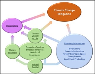
Green and Blue Infrastructure
4.10.4 Green and Blue Infrastructure is aAnetwork of multi-functional green and blue spaces and other natural features, urban and rural, which is capable of delivering a wide range of environmental, economic, health and wellbeing benefits for nature, climate, local and wider communities and prosperity.[3]
4.10.5Strategic Green and Blue Infrastructure (GBI) (which sits under the wider GBI) is a strategically planned network of natural and semi-natural areas that spreads throughout the District. One of the key distinguishing features of the Leeds District is the way in which the countryside runs into the main built up areas along corridors and valleys. Strategic GBI has strategic importance across the District due to its size, significance and corridor roles and is designated by Policy SP13 and identified on the policies map. A key feature of Leeds' GBI is the role it plays in bringing nature into the main urban area and its communities through GBI corridors.
4.10.6 5 GBI comprises multi-functional green spaces, both urban and rural, which includes protected sites, woodlands, hedgerows, nature reserves, river corridors, public parks and amenity areas, together with green links, river corridors, ponds, becks and river banks. It extends from urban centres through corridors to open countryside and supports the natural, recreational, and ecological processes which are integral to the health and quality of life of sustainable communities in the District. A key function of Strategic GBI in Leeds is to help maintain and enhance the character and distinctiveness of local communities and the wider setting of places.
4.10.57 Within both natural and semi-natural (or managed) GBI, environmental features can deliver a wide range of multifunctional ecosystem services, such as water purification, air quality, space for recreation and climate mitigation and adaptation. These is network of green (land) and blue (water) spaces can improve environmental conditions for plants and animals as well as health and quality of life for residents and visitors to Leeds. It also supports a green economy that can create job opportunities and is attractive to investors.
4.10.68 GBI includes biodiversity-rich natural areas such as woodland, ponds or grassland and may therefore be covered by other policies within the Core Strategy. These assets are often designated as part of the Leeds Habitat Network and form the main backbone for GBI in Leeds upon which other areas of GBI can be drawn upon to help nature flourish through corridors. Additional semi-natural spaces, such as parks and historic gardens and agricultural fields can also assist wildlife movement as well as improving local environmental quality and fulfilling other ecosystems services such as improving air quality. Strategic GBI has strategic importance across the District due to its size, significance and corridor roles and is designated by Policy SP13 and identified on the policies map.A key feature of Leeds' GBI is the role it plays in bringing nature into the main urban area and its communities through GBI corridors.
4.10.7 9 The natural environment can be degraded by land fragmentation, development and grey infrastructure such as roads. This affects habitats and species and reduces the functional coherence of GBI. Degraded ecosystems have lower species richness and are unable to offer the same ecosystems services as healthy ecosystems. Development therefore needs to seek to avoid such impacts on GBI and consider its wider benefits for natural capital and ecosystem services at the earliest stage of proposals.
4.10.10 7 The inclusion of areas forming part of the Strategic GBI network does not necessarily mean that no development can take place in these areas (unless precluded by other policies) but it does mean that all development must consider its impact on
the strategic GBI by carrying out a GBI assessment. Within these strategic areas the focus of the assessment should be on maintaining, reconnecting and enhancing GBI.
- Maintaining means ensuring that current GBI services are provided and severance is avoided
- Reconnecting involves ensuring that the network of
strategic GBI can assist plant, animal and human connectivity through measure such as developing corridors, land bridges, landscape buffering, linked urban greenways associated with active travel
- Enhancing means taking opportunities to maximise the multifunctional roles of
strategic GBI as well as remediating or mitigating any degraded land.
4.10.8 11 Not all of Leeds' GBI is easily mapped and there are semi-natural GBI assets such as private gardens, street trees, hedges, verges, green roofs and walls which also serve as important stepping stones for nature as well as serving important local community recreation. These also have
and amenity functions as well as fundamental roles in climate change mitigation and adaptation, and ecology. Therefore, to ensure that the cumulative value of GBI is recognised and planned for, GBI assessments will also be required for all developments to assess the
overall GBI assets and consider their role in development proposals. This assessment would recognise the intrinsic value of GBI assets, ensure their protection, enhancement or replacement via development and result in fewer impacts on biodiversity, amenity, trees and where possible, help to improve local environmental conditions e.g. designing in existing trees and small pockets of open spaces or de-culverting (or 'daylighting') of watercourses. Within these local community GBI areas the focus of the GBI assessments should be on retaining key assets, recognising the value of natural and semi-natural stepping stones and protecting or replacing them as well as seeking to plug into strategic GBI.
4.10.9 12 Not all of Leeds' strategic Green Infrastructure is easily accessible. An objective of the Core Strategy is to improve access. The network of Public Rights of Way (PROW) are is essential in helping to access the countryside and urban green space, linking people with place, and urban and rural areas. The Council expects that all development will safeguard existing PROW and wherever possible expand and improve the PROW network. (Policy G1).
Trees
4.10.13 10 Trees provide many benefits to our environment. They extract and store carbon emissions and take pollutants out of the air, provide shelter and shade and valuable habitats, reduce flood risk, soften the built environment, bring colour and texture, provide opportunities for us to reconnect with nature and help to support our physical and mental wellbeing which has been brought into particular focus by the restrictions on daily life due to COVID-19.
4.10.14 11 Leeds City Council has an ambition to increase tree cover from 17% of the overall land area of the city to 33% by 2050. To achieve this 350 – 550 hectares of tree planting per annum needs to take place
which is
significantly
higher than current planting rates. This action is part of the Leeds Road Map to net zero as set out in Policy SP0 which requires a range of measures working at the same time to mitigate and sequester carbon in order to remain within the legally set carbon budget for the District. The Council's Woodland Creation Scheme aims to plant 5.8million trees over the next 25 years on public land and the Council is a key partner in the White Rose Forest (WRF) initiative which will plant millions of trees in urban centres and countryside to improve the quality, quantity and access of woodlands across the city. One ambition of the WRF Strategy is that no household in Leeds is further than 500m from wooded spaces by 2050. By 2030, the tree planting target for the Leeds district is expected to have increased to 1500 hectares (equivalent to 2,100 football pitches) which will offset approximately 26,000 tonnes of carbon emissions. Achieving this is dependent on working in partnership with landowners, institutions, businesses, communities and volunteers and developments incorporating additional trees and hedgerows which will help to create high quality environments which provide for nature and people. Such planting will contribute to, and extend, the network of green links, improving and expanding connected habitat 'highways' for nature and providing health benefits (mental and physical) for people. It must, however, be recognised that tree planting is only one of many actions required to address the climate emergency and that tree planting alone will not be sufficient.
4.10.15 12 Given the urgency of the Climate Change Emergency the necessity to protect and increase the number of trees has never been greater. The
GBI Tree Policies in the plan will be based on the four following presumptions.
- A presumption against the loss of all trees
- A presumption that tree replacement will as a minimum equal the level of Carbon Sequestration lost
- Where possible the level of canopy cover for Leeds will be increased
- New Trees will be directed to areas with the greatest need
There is also an increasing need to
create and manage woodlands that are more resilient to
plant pests and diseases.
This can be achieved through planting a wider range of tree species, using seed from a wider range of origins and provenances, encouraging natural regeneration
and evolutionary adaptation and
protecting from damaging animals and herbivores.
Green Spaces
4.10.16 13 Within the GBI of the District, Green and Open spaces provide several functions within the urban and rural fabric of Leeds, including, the provision for play and informal recreation, a landscape buffer within and between the built environment and/or a habitat for the promotion of biodiversity and helping the city combat the effects of climate change. Overall, the spaces contribute to the cultural life of the community by also providing space for community events, general social interaction, participation and volunteering. Green Spaces is defined as: All open space and vegetation, whether public or private, used for formal or informal recreation of public value, including not just land, but also areas of water (such as rivers, canals, lakes and reservoirs) which offer important opportunities for sport and recreation and can act as a visual amenity.
4.10.17 14 The Council recognises that some Green Space, is neither natural or semi-natural, e.g. a Multi-Use Games Area or Skateboard Park, will both have considerable social but few natural benefits.
4.10.18 15 With the above in mind the Council disaggregates Green Space into Typologies (Policy G3) for Planning use. Policy G4a/b/c protects creates and maintains new Green Space as a result of development and Policy G6 protects all Natural Environment, areas of Open Space and other related areas.
Local Food Production
4.10.19 16 Global food systems account for 1/3 of total global greenhouse gas emissions and 46% of the food we eat in the UK is imported. As part of a holistic approach to reducing carbon in order to meet the targets set out in Policy SP0 it is important to consider what the development plan can do to assist
in the production of local food. The Council also recognises that everyone living, working or visiting the City should have affordable access to healthy food to maintain and enjoy an active lifestyle. Encouraging local food production can help to reduce food miles and the resultant carbon emissions. As part of the National Food Strategy Leeds is
has developeding its own Food Strategy with objectives including supporting greater local growing and improving the District's supply chains.
4.10.20 17 Whilst the planning system has a limited role on farming and food practices, associated development which supports a low carbon approach and diversification will be supported as these offer the greatest opportunities for agricultural land to play an enhanced role in supporting ecosystems, services and protecting natural capital. In association with new development the Council will seek to maximise opportunities for local food production, planting of fruit trees, Community Gardens, Forest Gardens,
Community Orchards and Allotments etc and will support low carbon,and sustainable, and nature friendly forms of agriculture (including hydroponics and indoor farming) in sustainable locations.
Biodiversity
4.10.21 18 Biodiversity is the term used to describe the variety of life on Earth which help us to live healthy and happy lives by providing food, raw materials, medical discoveries and ecosystem services. A healthy natural environment and ecosystem also provides elements such as natural pollination of crops, clean air, a supply of oxygen, clean water, extreme weather mitigation and human mental and physical well-being, recreation and even tourism.
4.10.22 19 The Earth's biodiversity is in decline due to human activities such as deforestation, land-use change, agricultural intensification, over-consumption of natural resources and pollution. A report from the Intergovernmental Science Policy Platform on Biodiversity and Ecosystem Services (IPBES) (2019) states that nature is declining globally at rates unprecedented in human history and the rate of species extinctions is accelerating. It concludes that a global transformative change (fundamentally doing things differently) is required in terms of economic, social, political and technological factors that will focus on greater conservation in terms of:
- the extent of areas protected and management of these areas
- more sustainable production in agriculture, forestry and fishing
- more sustainable consumption and addressing pressures such as overexploitation and pollution.
4.10.23 20 Biodiversity and climate change are inextricably linked through the intrinsic balance of nature and ecosystems therefore a significant change in biodiversity will inevitably impact on climate.
4.10.24 21 At a local level there is ongoing incremental loss of Leeds' indigenous natural environment through habitat destruction and a resulting loss in biodiversity. It is therefore important that the variety of life is protected and the trend of losing biodiversity is reversed through improved protection, enhancement and expansion of
designated nature conservation sites (such aslLocal
Wwildlife
Ssites)and
Ancient and
Long Established
Woodland,whilst seekingand opportunities through Biodiversity Net Gain (BNG)
to achieve this.
4.10.25 22 The decline in biodiversity is also partly due to people feeling less connected to nature and it is acknowledged that accessible natural greenspace is not distributed evenly across the District and communities with the greatest levels of deprivation, obesity, mental health problems and shortest life expectancy are also those with the least access to nature near where they live. The Government's 25 Year Environment Plan strives to make high quality nature spaces more accessible.
4.10.26 23 The Council's Best City Ambition is to
tackle poverty andreduce inequality and improve the
quality of life for everyone who calls Leeds home.health and wellbeing of the people who live and work in Leeds. BNG could contribute to this by guiding any residual off-site delivery to areas where there is poor access to nature reserves or other accessible natural open space. Natural England's Accessible Natural Greenspace Standards (ANGSt) thresholds provide targets to help identify the areas of Leeds that have the lowest current provision of accessible natural open space and will be used to help guide delivery of off-site BNGiodiversity Net Gain, within a framework also set by emerging Local Nature Recovery Strategies.
Design
4.10.27 24 It is recognised that any effort to mitigate Climate Change must be achieved with a holistic set of policies that interact. Design and placemaking play an important part of this approach and any policies associated with SP13 must promote good design to support the stated aims of Policies SP1Aa, SP1Bb and P10.
[Replace Spatial Policy 13 of the Core Strategy 2019 with the following new Spatial Policy 13]
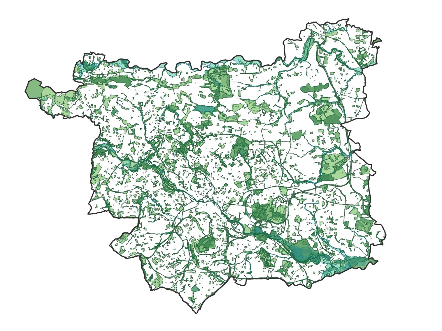
Green and Blue Infrastructure Map
Spatial Policy 13: Protecting, Maintaining, Enhancing and Extending Strategic Green and Blue Infrastructure
1. Leeds contains a significant network of strategic Green and Blue Infrastructure (GBI) comprising designated land for Green Space (Site Allocations Policy GS1 and AVLAAP Policy AVL14), Nature Conservation Sites (Policy G8a) and the Leeds Habitat Network (Policy G8b) together with additional assets including river corridors, lakes, ponds, woodland, Historic Parks and Gardens, functional flood plain and PROW. This is shown on the Policies Map and Map X. In total these contribute to and enhance the local and natural environment by providing multi-functional natural capital benefits and ecosystem services. These are designated as a strategic network of Green and Blue Infrastructure and indicated on the Key Diagram and identified on the policies map.
2a. In order to help protect, maintain maintain, enhance and extend the character of Leeds and enhance its environment all development and proposed allocations within the strategic network of GBI must follow the strategic principles of,
i. conserve and enhance existing GBI functions
ii. avoid severance of the strategic network
iii. take opportunities to enhance existing GBI functions
iv. extend GBI where appropriate and related to the development
2b.To help protect and enhance local GBI all development and proposed allocations outside of the strategic network of GBI must, in line with Policy G1, submit a GBI assessment
To be inserted in Section 5.5 of the Adopted Core Strategy
Amend title Section 5.5 as follows:
"Managing Environmental Resources, Green and Blue Infrastructure"
Delete "a) Green Infrastructure and Green Space"
Replace paragraphs 5.5.1 to 5.5.6 as follows:
Green and Blue Infrastructure
5.5.1In order to help maintain the character of Leeds and enhance its environment Policy SP13 sets out that all development and proposed allocations within the strategic network of GBI should protect and maintain existing GBI functions, avoid severance of the strategic network, enhance existing GBI areas and extend GBI where appropriate and related to the development.Policy SP13 also sets out that outside of the strategic network of GBI local assets all development should assess and justify asset loss, avoid severance, seek opportunities for extension of local GBI assets, and seek opportunities to support and extend the Strategic GBI network.
5.5.2There are important opportunities to enhance Green and Blue Infrastructure in Leeds so as to secure benefits from natural capital and ecosystem services.Policy G1 provides guidance for advancing this approach to conserving and enhancing the strategic network of GBI.
5.5.3Green Roofs can be seen to support good GI principles and can have multiple benefits. Likewise
5.5.4gGreen Wwalls can also support good GI; some are natural such as Ivy whilst others need to have their irrigation supported by mechanical intervention. Green walls also can support different types of plants which bring different and additional benefits.
5.5.5Whilst Leeds supports the principle of gGreen walls and Green roofs, there needs to be confidence that the benefits outweigh any disbenefits with regard to energy usage and subsequent maintenance. Green Wwalls and Green roofs will be supported where there is evidence of good design, and it can be shown that they are net carbon zero over their lifetime and subsequent lifetime management plans.
5.5.6Good Green and Blue Infrastructure cannot be in delivered in isolation. Policy G1 must be read and implemented along other policies that complement it in order to provide sustainable placemaking. With this in mind the aim of the Policy is to ensure that all GBI matters are assessed appropriately on all development and designed appropriately (See Strategic Policy -SP1B). The first priority will always be to protect the function of the Green and Blue Infrastructure.
Green Roofs and Walls
5.5.3 Green Roofs can be seen to support good GI principles and can have multiple benefits (Policy P10: Principles of High Quality Design &health Place-making). In the interests of climate change these will be expected to be delivered in conjunction with the requirements of Policy EN1B with the resultant preference being that which provides the best Climate Change benefit.
5.5.4 Likewise green walls can also support good GI. Green walls also can support different types of plants which bring different and additional benefits. In the main there are two types;
-
natural such as Ivy whilst -
others which need to have their irrigation supported by mechanical intervention.
5.5.5 Whilst Leeds supports the principle of Green walls and Green roofs, there needs to be confidence that the benefits outweigh any disbenefits with regard to energy usage and subsequent maintenance. Green walls and Green roofs will be supported where there is evidence of good design, and it can be shown that they are net carbon zero over their lifetime and subsequent lifetime management plans.
Assessing Green and Blue Infrastructure
5.5.6 Good Green and Blue Infrastructure cannot be in delivered in isolation. Policy G1 must be read and implemented along other policies that complement it in order to provide sustainable placemaking. With this in mind the aim of the Policy is to ensure that all GBI matters are assessed appropriately on all development and designed appropriately (See Strategic Policy - SP1B). The first priority will always be to protect the function of the Green and Blue Infrastructure.
5.5.2 There are important opportunities to enhance Green and Blue Infrastructure in Leeds so as to secure benefits from natural capital and ecosystem services. Policy G1 provides guidance for advancing this approach to conserving and enhancing the strategic network of GBI.
[Replace Core Strategy 2019 Policy G1 with the following new Policy G1]
a. Policy G1: Protecting, Maintaining, Enhancing and Extending Green and Blue Infrastructure Within and Outside Areas of Strategic GBI
b.
c. All applications must be supported by a GBI assessment.
i. GBI assessments should appraise proposed development sites for GBI functions related to:
(i) Habitat Enhancement
(ii) Access
(iii) Green and Open Space
(iv) Water Management including flood risk, waste water and sustainable drainage
(v) Amenity
(vi) Carbon Reduction and
(vii) Avoidance of Severance
d.a. The GBI assessment will need to address:include consideration of:
1) the type of development and its compatibility with GBI
2) maintaining and improving access to the strategic GBI network
3) creating opportunities that connect the site with the wider GBI network
4) managing and maintaining GBI assets throughout the life of the development.
5) how the laying out of new gGreen sSpaces provided within the development can protect, maintain, enhance and extend GBI
6) any need for specific GBI functions that do not fulfil Green Space functions and details of how these functions feed into the design of the development.
7) designing Green Spaces to a high standard so that they serve multifunctional purposes for human health, recreation, ecology, carbon capture and adaptation to the impacts of climate change
8) delivering Biodiversity Net Gain
9) the Leeds Habitat Network
10) existing trees
11) planting of new/replacement trees
12) managing water on site
13) flood risk management policies
14) community food growing for residents and the local community
14) 15) Public Rights of Way (PROW)
Delete "Map 16 Strategic Green Infrastructure"
Delete "Map 17 Leeds Woodland Sites above 2 hectares"
Replace paragraphs 5.5.7 to 5.5.XX as follows:
Trees
5.5.7 Trees play such a key role in the balance and health of the natural environment that it is vital that existing ones are allowed to grow and mature and new ones are planted to increase the extent and level of benefits they bring to the climate, nature and our lives as humans.
5.5.8 Trees and woodland cover are important components of the Leeds' environment and landscape character. In 2018 there were 9,468 hectares of woodland within the Leeds District, representing 17% of the land area. Over 1400 hectares of woodland is owned and managed by the Council, from large estates such as Temple Newsam and Chevin Forest Park, to small, urban woodlands such as Skelton Wood in North EastWhinmoor.
Protection of Trees, Woodland and Hedgerows
5.5.9 Section 4.0: Planning for Climate Change outlines Leeds' ambitions for addressing climate change and aiming for net zero by 2030 and Policy SP0 recognises the importance of trees in climate change mitigation and adaptation. In order to maximise the benefits of existing trees, it is important that they are protected and only removed if there is full and clear justification to do so. Certain trees already enjoy some level of statutory protection through, for example, Tree Preservation Orders, Conservation Area designations and identification in neighbourhood plans. Ancient Wwoodland, aAncient tTrees and vVeteran Ttrees are recognised nationally as irreplaceable habitats and as such, they merit the strongest protection under the planning system and planning policy. It is important in terms of climate change and the health of the environmental health that we protect and enhance existing trees and woodlands and plant more as they are an extremely valuable natural way of reducing carbon dioxide in the atmosphere, enhancing biodiversity, cleaning air and water, reducing flood risk and improving health and wellbeing. Indeed, a large, mature tree could store well in excess of 1 tonne3.5 tons of carbon over its lifetime. Areas of woodland provide the highest concentrations of trees and carbon storage however the study 'Informing a carbon-based tree planting strategy for the White Rose Forest' (UBoC, White Rose Forest, University of Leeds, 2021) a study undertaken by the University of Leeds concludes that 1% of regionsLeeds CO2 emissions in 2018 wereis taken up by trees outside woodlands, such as those in urban areas.
5.5.10 Whilst trees are natural features and therefore contribute to biodiversity, the need to protect and increase tree cover is considered separately to the protection of biodiversity and biodiversity net gain. in recognition of their critical roles beyond biodiversity, in storing carbon and pollutants and their amenity and landscape value. Indeed, trees and woodland, in particular, capture more carbon, more quickly than any other natural habitat. Natural England's Carbon Storage and Sequestration by Habitat: a review of the evidence (2nd Edition) states that 'The largest carbon sequestration rates amongst semi-natural habitats are in woodlands. Native broadleaved woodlands are reliable carbon sinks that continue to take up carbon over centuries with benefits for biodiversity and other ecosystem services. Native woodland managed with a minimum intervention approach can be an effective climate change mitigation measure.
Policy G2A applies to all developments requiring planning permission. It applies to all Category A, B and C trees and hedgerows as defined under BS 5837. Category U trees and Category U hedgerows are exempt unless they are deemed to be a veteran tree or a candidate veteran tree.
When determining the extent of any tree or hedgerow removal prior to the submission of a planning application, the Council will use the most up to date data available, including the Bluesky National Tree Map which provides data from 2018.
Felling should be clearly defined in any planning applications. Any trees subject to felling not identified could be subject to the need for a felling licence from the Forestry Commission
[Replace Core Strategy 2019 Policy G2 with the following new Policies G2A, G2B, G2C, G2D]
Policy G2A - Protection of Trees, Woodland and Hedgerows
a) All woodlands,
Category A, B and C trees and
Category
A, B and Chedgerows willshould be retained and undamaged unless
there is an overriding justification for their removal
which isis justified and agreed by the Local Planning Authority through the submission of an up to date and appropriate tree
and/or hedgerow survey andassessment of carbon sequestration, storage of pollutants, biodiversity and amenity value. which clearly demonstrates that:
b) In addition, it must be demonstrated
through the planning application process
that:
1. Development cannot be redesigned to retain trees and hedgerows; and
2. The need for development clearly outweighs any harm to the ecological and amenity value of the
woodland, Category A, B and C trees
and
Category A, B and C
hedgerows to be removed, their carbon sequestration value and the landscape quality of the area; and
3. Any trees removed will be replaced in compliance with the tree replacement methodology in Policy G2cD
c) When assessing existing woodland, trees and hedgerows, regard will be had to the removal of trees and hedgerows, to facilitate and increase the amount of developable land on a site, prior to the submission of a planning application.
Evidence of woodland, tree and hedgerow existence since 2018prior to submission will be sought if there are signs of unjustified removal prior to submission and criterion 1 abovethis policy will apply to those species removed as if their removal had not taken place.
If unjustified removal has taken place, the Council will apply this policy against the latest evidence available of trees, woodlands and hedgerows on the site using mapping data and local knowledge.
d) Any removal of hedgerows must comply with the Hedgerow Regulations 1997.
Replace paragraphs 5.5.XX to 5.5.XX as follows:
Ancient Woodland, Ancient Trees and Veteran Trees
5.5.11 The Woodland Trust states that "Ancient woodlands are the richest and most complex terrestrial habitat in the UK and they are home to more threatened species than any other." (ref). They cover 609,990 hectares (2.5%) of the UK land and include ancient semi-natural woods and
Pplantations on
Aancient
Wwoodland
Ssites (PAWS).
5.5.12 Ancient wWoodlands are
areas of woodland cover that haves been in continuous existence since 1600AD and can be determined by factors such as the existence of key indicator plants, evidence of historic industry and management. They are recognised for their high quality, relatively undisturbed soils and high levels of decay which support the ideal habitat for many fungi, invertebrates, insects, birds and animals. Their importance in terms of biodiversity cannot be overestimated, (particularly in terms of factors such as aging and wood decay) but they also have cultural, heritage and landscape value, are beneficial to our health and wellbeing and capture and store carbon. In recognition of this and their uniqueness they are classified as irreplaceable habitats which cannot be recreated.
5.5.13 They are, however, susceptible to damage and loss due to development. National policy recognises this by stating that any application that would
result in the loss or deterioration ofdamage an irreplaceable habitat willshould be refused,
unless there are wholly exceptional reasons
and a suitable compensation strategy exists. If there is an overriding justification for damage and loss
is justified in line with this approach to occur, the mitigation hierarchy approach will be taken.
a. Avoid habitat damage and prevent negative impacts e.g. re-design scheme
b. Minimise any habitat damage or loss e.g. screening barriers
c. Remediate any habitat damage or loss through restoration e.g. creating buffer zones
d. Compensate any habitat damage or loss e.g. plant new woodland
5.5.14 The planting, maintenance and management of buffers with scrub and trees can protect existing aAncient
Wwoodland and be the aAncient wWoodlands of the future therefore public access and manmade features will be resisted.
A buffer of 50 metres to Ancient Woodland
will protect the existingaAncientwWoodland and expand woodland cover in Leeds. The 50 metre width is based on the following principles and asScheme for
Ancient wWoodlandeProtection and
Expansion as required through policy G2B should include the following elements which are illustrated
in
Diagram XX:
- Width required for establishment of one open-grown Large tree (such as an English Oak) based on RPA radius of 15.6 metres (total width = 31.2 metres) and with native woodland shrubs and ground floraallowed encouraged to establish beneath it
- 10 metres of associated more-open habitat to provide eco-tones and mimic a woodland glade/ride through scrub and tall ruderal habitats
-
The combined width of the two principles above (approximately 40 metres) will need to be designed to deter public access and therefore will largely accommodate any naturally falling adjacent mature trees (or limbs from such trees) from the existingaAncientwWoodland or the new open grown Large tree referred to above. Conflicts with public safety will be minimised and the important biodiversity role of retaining standing and fallen deadwood as part of theaAncientwWoodland ecological community can therefore be facilitated - Beyond the 40 metre width required as outlined above, there should be up to 10 metres for a meadow strip to provide another ecotone to the edge of the woodland. This can also provide public access through low-impact infrastructure such as surfaced paths and in such cases should include appropriate fencing to protect new woodland expansion and/or an appropriate boundary feature to the adjacent woodland
-
Where only part of the buffer falls within the development site, bespoke protection and woodland expansion measures should be agreed
DiagramXX
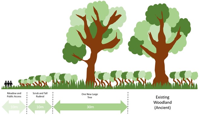
A buffer to Ancient and Veteran trees will
help
protect these trees and allow them to decline over as long a period of time as possible whilst retaining standing deadwood, whilst periodic, specialist,
positive management might be required to ensurelong-term
structural integrity. The buffer width is based on the following principles and a
Scheme for
Ancient and
Veteran Tree
Protection,Management and
Interpretation as required through G2Bshould include the following elements:
-
Where the tree
and buffer
is within the development site
and
forms
part of the on-site greenspace
there will need to be appropriately designed protective fencing to deter
safety
conflicts between
people and features of standing deadwood. Positive management of the tree to extend its life and also
provision of
an interpretation panel to explain the biodiversity features of such trees and their need for
specialist
management -
Where only part
of the buffer is within the development site
bespoke protection measures
should be agreed
Central government and many organisations have issued guidance on how to consider
Aancient wWoodlands within planning decisions. In addition to aAncient wWoodlands, there is also a need to protect long established woodland and aAncient and vVeteran
Ttrees and ensure long established woodland andaAncient and vVeteran tTrees of the future are planted, maintained and managed.
5.5.15 TheNatural England's Ancient Woodland Inventory
and maps identify sites greater than 2ha whilst West Yorkshire Ecology is working to identify sites of less than 2 ha. It is acknowledged that not all aAncient wWoodlands have necessarily been identified and it is important to protect all areas that meet the aAncient wWoodland definition. Early consultation with the Council's tree officers is recommended on development which may affect any woodland meeting the criteria for aAncient wWoodland and any trees meeting the criteria for
Aancient and vVeteran tTrees
(as defined in the NPPF). Ancient Trees are recorded on the Ancient Tree Inventory.
5.5.16 It is important that comprehensive and robust information and evidence is submitted with a planning application to ensure the successful protection of aAncient wWoodland,
Aancient tTrees and vVeteran tTrees. Tree surveys should follow guidance set out in British Standard BS 5837 'Trees in relation to demolition, design and development' and ecological surveys should follow best practice, for example by the Chartered Institute of Ecology and Environmental Management and Natural England. Policy G2b: Ancient Woodland, Long Established Woodland, Ancient Trees, Veteran Trees.
[InsertReplace Policy G2 of the Core Strategy 2019 with new Policy G2B b]
Policy G2B - Ancient Woodland, Long Established Woodland, Ancient Trees, and Veteran Trees
a) Development resulting in the loss or deterioration of irreplaceable habitats, including Ancient Woodland (aAncient sSemi-nNatural wWoodland, pPlantations on aAncient wWoodland sSites and aAncient wWood pPasture and hHistoric pParklands), Long Established Woodland, Ancient Trees or Veteran Trees willshould be refused, unless there are wholly exceptional reasons and full compensation measures can be demonstrably delivered.
b) Through the submission of In addition to demonstrating Eexceptional reasons, should be accompanied by detailed and robust evidence, it must be shown that in accordance with the following hierarchy:
1. No appropriate alternative development site exists; and
2. Development cannot be redesigned to prevent the loss of, or deterioration of detrimental impact on, aAncient wWoodland, aAncient tTrees or vVeteran tTrees: and
3. There is an overriding need for the proposed development which, in conjunction with exceptional benefits delivered, justify the loss or damage of irreplaceable habitats. Unequivocal evidence will be required over and above any compensatory measures to show the need and benefits of the development clearly outweigh any harm to the ecological and amenity value of the trees to be removed, their carbon storage abilities and the landscape quality of the area; and
4. Any trees removed will be replaced in compliance with the tree replacement methodology in Policy G2CD and
4. 5. A suitable compensatory strategy is prepared alongside the planning application, which is demonstrably deliverable
5. Impacts on irreplaceable habitats will always result in loss and cannot be offset elsewhere.In order to prevent loss or deterioration and the damaging effects this can have on biodiversity, air quality, soils, habitat connectivity and woodland ecosystems
6. Harmful development will not be acceptable within 50m of Ancient Woodland or 30m of Long Established Woodlandand where these buffers form part of a development site a scheme for woodland expansion and avoiding any light spill will be required.
6.
Harmful development will not be acceptable within a distance 15 times largerdiameter of an Ancient or Veteran Tree or 5m beyond the edge of the tree canopy (whichever is the larger) and where these buffers form part of a development site a scheme for protection and interpretation will be required. Such trees should not form part of any private garden space.
Buffers
Buffers will be used to prevent loss or deterioration and the damaging effects development can have on biodiversity, air quality, soils, habitat connectivity and woodland ecosystems and to increase woodland planting and cover.
Ancient Woodland Buffer Distance
a) Development which would cause harm, either directly or indirectly will not be permitted within 50 metres of Ancient Woodland, unless it is clearly evidenced that such harm cannot be avoided by locating on an alternative site with less harmful impacts, can be adequately mitigated, or, as a last resort, compensated for.
b) In order to avoid deterioration and provide expansion of woodland cover in Leeds:
i) Where the 50 metre buffer forms part of a development site a Scheme for Ancient WoodlandProtection and Expansion and avoiding any light spill will be required
ii) No closer than 40 metres to the Ancient Woodland the buffer may include low-impact infrastructure for public access such as surfaced paths and in such cases should include appropriate fencing to protect new woodland expansion and/or an appropriate boundary feature to the adjacent woodland
Ancient and Veteran Trees Buffer Distance
a) Development which would cause harm, either directly or indirectly will not be permitted within a distance of 15 times larger than the diameter of an Ancient or Veteran Tree or 5m beyond the edge of the tree canopy (whichever is larger) unless it is clearly evidenced that such harm cannot be avoided by locating on an alternative site with less harmful impacts, can be adequately mitigated, or, as a last resort, compensated for.
b) In order to avoid deterioration, where the buffer forms part of a development site a Scheme for Ancient and Veteran TreeProtection, Management and Interpretation will be required. Such trees should not form part of any private garden space.
c) As Ancient Woodland, Ancient and Veteran Trees are irreplaceable, possible compensation will not form part of the assessment to determine whether the
wholly exceptional benefits ofreasons for the development proposal outweigh the loss.
d) This policy will apply to all aAncient wWoodlands, aAncient and vVeteran tTrees, whether they are included on the Ancient Woodland Inventory, the
Ancient Tree
Inventory, recognisedvVeteran
Ttree lists or maps andor the Policies Map or
not.meet the definitions of these terms.
Replace paragraphs 5.5.XX to 5.5.XX as follows:
Long Established Woodland
Ancient Woodland is considered the most important woodland resource for biodiversity and historic value in England because it has been around for the longest time (over 400 years). However, we also need to recognise the value that other more recent but well-established woodlands play and protect these so that they become the Ancient Woodlands of the future. The UK Government's "England Trees Action Plan 2021 -2024" (May 2021) introduces a new category of Long Established Woodland recognising their high ecological and societal role alongside Ancient Woodland.
Long Established Woodland in Leeds consists of woodland that has been continuously present since at least 1854, the date of the first series of detailed Ordnance Survey maps for West Yorkshire (forming part of the Epoch 1 series of national maps). This network of Long Established Woodland, which is at least 170 years old, has been identified by West Yorkshire Ecology and is shown on Map XX and the Policies Map.It will need to be kept under review to keep it up to date.
Long Established Woodland Map
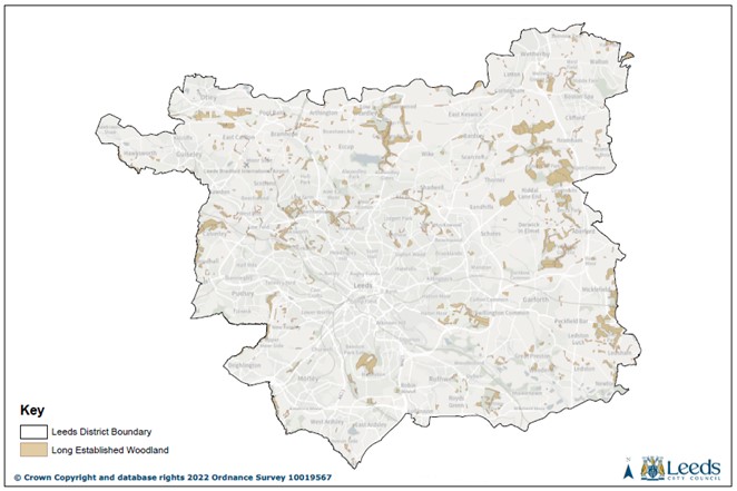
A buffer of 30 metres to Long Established Woodland has been selected to both protect the existing woodland and expand woodland cover in Leeds. The 30 metre
width is based on the following principles and a
Scheme for
Long Established Woodland Protection and
Expansion as required through policy G2C should include the following elements which are illustrated in Diagrams x
and xx:
-
Width required for establishment of one open-grown Large tree (such as an English Oak) based on RPA radius of 15.6 m (total width = 31.2 m) and with native woodland shrubs and ground flora
encouraged to establish beneath it -
Or width required for establishment of one open grown Medium tree (such as a Silver Birch or Mountain Ash) based on RPA radius of 10.8 m (total width = 21.6 m) with native woodland shrubs and ground flora
encouraged to establish beneath it. Together with up to 10 m of associated habitat to provide eco-tones and mimic a woodland glade/ride through scrub, tall ruderal and meadow strip -
Where only part of the buffer is within the development site
bespoke protection and woodland expansion
measures
should
be agreed
Table 8-1 Individual Urban and Rural Trees by size class from The Biodiversity Metric 4.0 User Guide (First published March 2023)
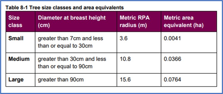
Diagram x
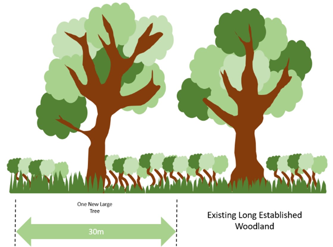
Diagram xx
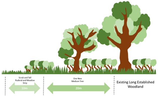
[Insert new Policy G2C]
Policy G2C - Long Established Woodland
A)
Long
Established
Woodland,
as designated through this policy and shown on
Map XX and
the Policies Map,
should be retained and undamaged unless removal is justified and agreed by the Local Planning Authority through the submission of an up to date and appropriate tree survey and assessment of carbon sequestration, storage of pollutants, biodiversity,
amenity value and historical
and social
significance, and compensation measures can be demonstrably delivered.
b)
Evidence should be submitted to
demonstrate that:
-
Proposals cannot be redesigned to prevent the loss of, or detrimental impact on
Long
Established
Woodland: and -
The need for development clearly outweighs any harm to the ecological, amenity
and historical
value of the
Long Established Woodland
to be removed, their carbon sequestration value and the landscape
quality of the area: and -
Any trees removed will be replaced in compliance with the tree replacement methodology in Policy G2D
Long Established Woodland Buffer Distance
a) Development which would cause significant harm, either directly or indirectly will not be permitted within 30 metres of
Long Established Woodland, unless it is clearly evidenced that such harm cannot be avoided by locating on an alternative site with less harmful impacts, can be adequately mitigated, or, as a last resort, compensated for.
b)
In order to reduce harm and provide expansion of woodland cover in Leeds:
i) Where the 30 metre buffer forms part of a development site a
Scheme for
Long Established Woodland
Protection and
Expansion and avoiding any light spill will be required
ii) The buffer may include low-impact infrastructure for public access such as surfaced paths and in such cases should include appropriate fencing to protect new woodland expansion and/or an appropriate boundary feature to the adjacent woodland
Replace paragraphs 5.5.XX to 5.5.XX as follows:
Tree Replacement
5.5.17 The removal of trees has a detrimental impact on the natural environment through, for example, a reduction in future carbon storage capacity and the depletion of shelter and shade. It is therefore important to replace trees lost. In recognition of the importance of trees' ability to store carbon dioxide within the Council's overall response to the climate emergency, the University of Leeds and the United Bank of Carbon
have devised a replacement methodology to achieve parity in carbon sequestration despite loss of existing trees.
The aim is to achieve parity at time of replacement planting. The methodology considers the condition, species and stature of the removed tree and the replacement trees as they impact on their ability to sequestrate carbon. The tables below set out the replacementtree numbers
(of Extra Heavy Standards) depending on the diameter and stature of the tree to be removed and the stature and condition category (BS 5837: 2012) of the replacement trees.
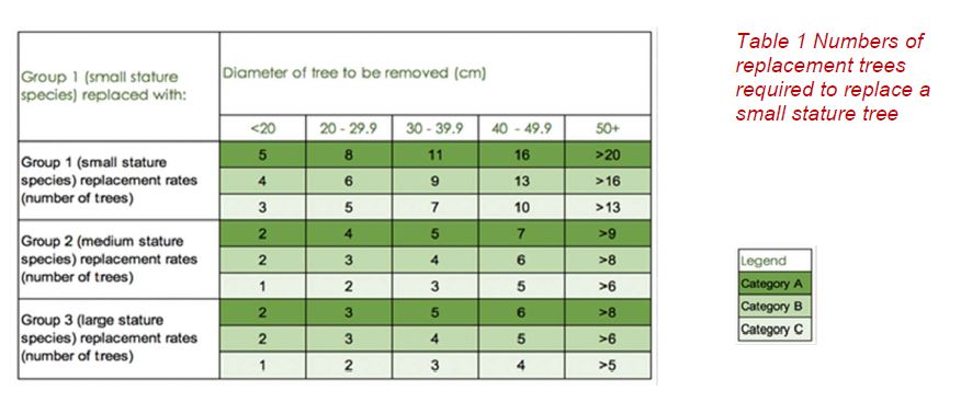
Table 1 Numbers of replacement trees required to replace a small stature tree
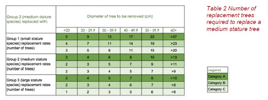
Table 2 Number of replacement trees required to replace a medium stature tree
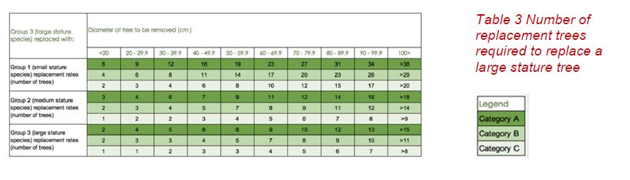
Table 3 Number of replacement trees required to replace a large stature tree
Table 'LPU 3'
Categories as defined in BS 5837: 2012
The stature of the Tree will that as defined by the 'Tree Selection for Green Infrastructure – A Guide for Specifiers – Trees and Design Action Group'
5.5.18 Use of Tree Replacement Tables (Figure 'LPU 3'):
Step 1: Establish the Stature of the Tree to be replaced (Small, Medium or Large) and use corresponding table.
Step 2: Establish the Diameter of the tree to be replaced and read down appropriate column.
Step 3: Establish the type stature of replacement trees (small, Medium or large)
Step 4: Read across to 3 options (Dark Green (A), Green (B) and White (C)).
Step 5: Read the replacement figure against the category of the Tree to be replaced A, B or C.
5.5.19 A detailed calculator to determine the number of replacement trees required can be found on the Council's website www.leeds.gov.uk
Policy G2C applies to all developments requiring planning permission. It applies to all Category A, B and C trees as defined under BS 5837. Category U trees are exempt unless they are deemed to be a veteran tree or a candidate veteran tree.
[Insert new Policy G2D]
Policy G2CD – Tree Replacement
1. All development should conserve trees and introduce new tree planting where appropriate opportunities exist within the boundary of the development as part of creating high quality living and working environments and enhancing the public realm.
2. Where removal of existing
Category A, B and C trees outside woodland is unavoidable, justified and agreed with the Local Planning Authority, those trees removed will be replaced with an appropriate number, size and type of
extraheavy standard tree calculated using the Council's tree replacement methodology based on preventing loss of carbon sequestration capacity.
3. Replacement planting will be provided on site
outside private gardens, as part of an overall landscape schemeto be agreed by the Local Planning Authority.
3.4. Where on-site replacement is not possible and sSubject to full and detailed justification, a proportion of the replacement planting may be located off-site or where this is not possible. the payment of a financial contribution will be required to fund off-site planting in locations that will extend and enhance the network of blue and green infrastructure.
4.5. Detailed ongoing maintenance and management arrangements should be set out in a
landscapingplan, approved by the Local Planning Authority and implemented to retain replacement planting
for the lifetime of the developmentin perpetuityfor on-site planting and
for 30 years for off-site planting.
5.
6. The use of native and local species, the planting of fruit trees and those that attract wildlife will be encouraged. Trees planted should be appropriate for their location.
Green and Blue Space
Introduction and Aims
5.5.20 The overall aim of the Local Plan Ggreen and Bblue space policies is to strategically deliver the best type and the best quality of Ggreen and Bblue space to where it is most needed in Leeds.
Standards (Surplus and Deficiencies)
5.5.21 Leeds benefits from good overall provision of green
and blue space. However, this is not distributed evenly across the City and as a result, some areas have very little nearby green
and blue space and some of it is of a poor quality. Policy G3 sets standards for the quantity, accessibility and quality of green
and blue space to be expected derived from the evidence of the Leeds' Open Space and Recreation Assessment (2011) and updated as part of the Site Allocations Plan (2017). Whilst it is recognised that the existing urban form of Leeds offers limited scope to achieve all of the standards, particularly in the inner areas, there is a need to maximise the development opportunities that do arise to optimise quantity, accessibility and quality as appropriate.
5.5.22 The measurement of surplus and deficiencies provides a technical base to evidence deficiencies of Ggreen and Bblue Sspace such that an undersupply of Ggreen and Bblue Sspace across Leeds is recognised. This recognition allows for the policies that demand extra space as per the 'burden' principle in 5.5.234. It is recognised that the delivery of Ggreen
and blue space types (typologies) is dependent on a range of factors and, with this in mind, care should be taken in using surplus and deficiencies based on G3 to evidence a demand for a specific typology. For instance, the need for a Sports pitch in Leeds is based on overlapping factors such as local demand of teams, number of teams in a club, number and condition of pitches and the distance people will travel to a playing pitch.
New Housing Development
5.5.23 People moving into an area or general increases in population place a greater burden on existing green space. Therefore, it is appropriate that new housing development makes provision to address this burden by:
- providing green and blue space on-site, or
- providing green and blue space off-site, or
- providing commuted sums in lieu of on-site provision. Sums can be used to provide green and blue space, to enhance existing green and blue space or to improve connections to existing green and blue space or
- a combination of these options.
It should be noted Policy G4 clearly states that it should be provided On-Site and provides aThe calculation of area of green and blue space provision in Policy G4 which is based upon a requirement for different sizes of dwellings. Where it is agreed that only part of this requirement is provided as new green or blue space (on or off-site) the shortfall should normally be provided in lieu as a commuted sum (see below for calculation).
Eligible Development
5.5.24 Green space will be sought from developments of 10 or more dwellings (class C3 of the Use Class Order) and PBSAs. Residential institutions (Class C2 of the Use Class Order) will not be expected to provide green or blue space. Any other residential developments (sui generis or mix of C2 and C3 use classes) will be judged on their merits. Residential developments of less than 10 dwellings will be encouraged to provide on-site green space, as part of meeting placemaking requirements set out in Policy P10.
[Policy G4 (renamed G4A) has been amended to include new wording highlighted in italics. Amended and new policies G4A, G4B and G4C. Delete policy G5 of the Core Strategy 2019]
Policy G4A: Green and Blue Space Improvement and New Green and Blue Space Provision
a) Residential developments of 10 dwellings or more will be required to provide the following quantities of on-site green
and
blue space per residential unit or where this quantity of green
and blue space is unachievable or inappropriate on-site, equivalent off-site provision, financial contribution in lieu of provision or combinations thereof should be sought:
1 bedroom dwelling 23sqm
2 bedroom dwelling 33sqm
3 bedroom dwelling 44sqm
4 bedroom dwelling 54sqm
5 or more bedroom dwelling 66sqm
Student bedspaces 18sqm
In determining whether this quantity of provision should be delivered on-site, off-site or as a commuted sum, consideration of the following are relevant:
a. local deficits in quantity & quality green and blue space
b. quantum and quality of greenspace feasibly achievable on site
c. potential for other development sites to deliver green and blue space
d. the development generating a need for play facilities that do not currently exist in the locality, and
e. potential to combine green space provision with wider multi-functional requirements e.g. Sustainable Urban Drainage Systems.
Determining if on-site or off-site provision (including contributions) will be appropriate
5.5.25 Different parts of Leeds have different needs and opportunities for green and blue space provision. Inner city areas often have the highest needs and the least opportunities for new provision. Individual site circumstances will also need to be considered in deciding when green and blue space ought to be provided on-site or not.
Quality of Green and Blue Space
5.5.26 Determining the appropriate location of green and blue space within a development will be a matter for discussion depending on the circumstances of the locality, site and development proposed. Aggregated, fragmented spaces, scattered across a development site will not be acceptable due to their limited functionality. However, it is recognised that there is a role for smaller areas of green space like 'pocket parks' in densely developed areas, subject to suitable management arrangements being in place.
5.5.27 It is important that any new green and blue space of any typology is planned, situated and designed to make a positive contribution to the overall design concept and character of development.
5.5.28 Some forms of green space suffer in terms of usability due to poor drainage (for example sports pitches). Any new green space should have acceptable and appropriate levels of sustainable drainage.Green Spaces need good drainage. For example, a poorly drained Sports Pitch will curtail its ability to be used multiple times a week. Underground water storage can sterilisethe ability to produce high quality, well designed Green Space above the tanks (Note: Leeds will always prefer sustainable options rather than the use of tanks). In the implementation of Policy G4B applications for new development will be required to consider flood risk, commensurate with the scale and impact of the development. To this endPolicy Water 7 will need to be addressed.
Policy G4B: HighQuality of New Green and BlueSpace
a) New Ggreen
and blueSspace should be of a high quality reflecting the principles set out below. Poor quality Ggreen
and blueSspace will not be supported.
b) In order to be considered high quality
new green
and blue space should seek to meet the following objectives:
a. provided on-site for the benefit of all residents in the local community
b. Green
and Blue Spaces must be open to the Public and not be territorial
c. serve multifunctional purposes for human health, recreation,
play sufficiency ecology, carbon capture and adaptation to the impacts of climate change
d. make use of existing features of sites such as GBI assets, corridors and topography
e. usable for recreation including facilitating movement, play – both formal and informal, rest and observing nature
f. work comprehensively for the occupiers of the development and the local community as a whole
g. spaces must not be isolated, narrow, exclusively linear, fragmented and have natural surveillance for safety
h. accessible for all users (including disabled people)
i. provision of seating that is designed for all users in appropriate locations
j. clearly defined boundaries and access points to ensure spaces feel safe and legible for all users
k. boundary treatment planting to soften edges, maximise biodiversity value and improve air quality
l. suitable for informal games and community gatherings.
m. must include new tree planting unless justified otherwise
n. show how the space has been
designed to be
is safe and
welcoming for
girls and young women
m.
o. a mix of formal and in-formal play provision with innovative spaces using natural materials and varied planting to allow imaginative play and connection to nature
p. Is suitable for children and young people of different ages and abilities in line with local play sufficiency.
n. q. Any play provision needs to be designed in accordance with national guidance (such as Fields in Trust) and local play sufficiency assessments.
Quantity of Green and Blue Space in High Density Developments
5.5.29 As the green and blue space requirement is expressed as an amount of green and blue space per dwelling, high density developments (65dph or higher (net)) usually found in or on the edge of town centres may generate requirements for green space that cannot be delivered on-site. For such schemes a minimum expected level of 20% of green and blue space should be provided on-site with the residual being provided off-site or in the form of a commuted sum. However, it is accepted that there may be particular site circumstances to justify a lower quantity than 20% on-site.
Maintenance
5.5.30 Any provision of new green and blue space will need to be accompanied by appropriate arrangements to secure the on-going maintenance of the space. Where the City Council is asked to adopt spaces, a financial contribution will be required to cover maintenance. Where independent or private arrangements are to be used the Council will need to be satisfied that these are robust, efficacious and legally enforceable. In particular the Council will be need to be satisfied as to the quality of the maintenance and that any legacy arrangements associated with the private company passing on their obligations or becoming insolvent do not result in the Council accepting the extra maintenance cost burden.
Policy G4C – Maintenance of Green and Blue Space
1. Arrangements to secure on-going maintenance for all new Green and Blue Space are required.
2. Where the Council is asked to adopt spaces:
a. a financial contribution will be required to cover maintenance for 15 years
b. arrangements must be agreed with the Council prior to commencement of the development.
3. Where private arrangements are proposed the Council must be satisfied that
a. the Green and Blue Space will be maintained in perpetuity.
b. the liability to maintain the Green and Blue Space transfers with title to the land management and quality arrangements decided at the planning stage to be maintained to ensure no loss of GBI assets.
1. Arrangements to secure on-going maintenance in perpetuity for all new Green and Blue Space are required.
2. Where the Council is asked to adopt spaces:
a. a financial contribution will be required to cover maintenance for 15 years
b. arrangements must be agreed with the Council prior to commencement of the development.
3. Where private arrangements are proposed the Council must be satisfied that
a. the liability to maintain the Green and Blue Space transfers with title to the land.
Safe Access to the Public and Other Issues
5.5.31 Where new green and blue space is provided it should be openly accessible to the public. Exceptions may be for operational reasons such as security of allotments or membership of sports clubs.
5.5.32 Where a need for play facilities is identified careful consideration should be given to safety and security issues. If security cannot be ensured through appropriate siting of play facilities, it may be appropriate to seek a different type of green and blue space irrespective of need.
Financial Contributions
5.5.33 As an alternative to provision of green space, financial contributions may (where appropriate and in compliance with the policy) help meet the demands of new residents on existing green and blue spaces. The calculation will be based on:
6. the quantity of the green and blue space requirement that will be converted into a commuted sum, i.e. the remainder not delivered on or off-site.
7. the laying out costs of the stated deficiency.
8. Maintenance for a 15 year period
9. a child contribution factor
10. a fixed amount for the maintenance of Playspace.
11. A percentage cost against the layout for professional fees.
5.5.34 All of the above will be adjusted annually using a SPONS index figure. The Council will provide a detailed calculation on its website updated annually with the latest SPONS figures. If green space is to be laid out by the developer for adoption by the Council, a 15 year maintenance sum should be calculated.
5.5.35 If a contribution in lieu of On-Site Green and Blue Space is agreed then regardless of the distance of the scheme on which the contribution is proposed to be spent: must show benefit to the users of the development. Also:
1. Green and Blue Space related benefit to the users of the development most be shown or/and The scheme on which the contribution money is to be spent should relate to the development using the distance standards in G3.
or
2. A The scheme on which the contribution money is to be spent is one identified as part of a wider Green and Blue Space Strategy for the City.
Protection of Green and Blue Space
5.5.36 There will only be an adequate supply of green and blue space, where the needs of the existing community are satisfied in all space types as set out in Policy G3 (green space standards), and there is an additional capacity of 10% of the total accessible green space. An allowance capacity of 10% is required to maintain the existing supply whilst absorbing the cumulative pressure on green space from developments that are not required to contribute towards the quantitative provision or improvement of green and blue space.
5.5.37 If the above calculation reveals a type of green and blue space is in excess of adequate supply, then prior to release for other uses it must also be assessed to ensure that it offers no potential for transformation to any other green and blue space type deficient in the same area. For example, an area may have an adequate supply of amenity green space, but a deficiency of allotments. Prior to release of the surplus amenity green space for redevelopment, the potential of the amenity space to be used for allotments should be thoroughly assessed.
5.5.38 Where supported by evidence and in the delivery of wider planning benefits, opportunities to improve existing greens and blue space quality may be delivered through redevelopment of green space. Such an approach will need to demonstrate a clear relationship between the loss of green and blue space, improved quality of green and blue spaces in the same locality. support of the local community living in the locality.
[Policy G6 of the Core Strategy is amended with new wording is shown in italics]
Policy G6: Protection of Existing Green and Blue Space
(i) Green and Blue Space is defined as:
- Sites designated in the Local Plan including Neighbourhood Plans
- Green Spaces created through the application of Development Plan Policy
- Open Space and Pedestrian Corridors in the City Centre
- Other spaces which meet the NPPF definition of Open space that have not been allocated for alternative land uses in the Local Plan
(ii) Green
and Blue Space will be protected from development unless
A)
the green and blue space is not required for the purposes of climate change adaption such as tree planting or local food growing
And
B) one of the following criteria are met.
- there is an adequate supply of all typologies of accessible green
and blue space within the analysis area and the development site offers no potential for use as an alternative deficient open space type; or - the green space lost is re-provided by an area of at least equal size, accessibility and quality in the same locality; or
- where supported by evidence and in the delivery of wider planning benefits, redevelopment proposals demonstrate improvements to existing green space in the same locality;
and -
the greenand blue
space is not required for the purposes of climate change adaption such as tree planting or local food growing.
[Existing 5.5.39 and existing POLICY G7 to be placed in here]
[Replace paragraphs 5.5.28 - 5.5.29 as follows]
Nature Conservation and Biodiversity
5.5.40 The pivotal role nature and biodiversity plays in balancing the world and its atmosphere is widely recognised. It is therefore critical that the natural environment and biodiversity in Leeds is robustly and comprehensively protected through legislation and planning policy and allowed to flourish and expand.
5.5.41 Biodiversity is not just about rare or threatened species or habitats, it is equally concerned with ensuring that widespread and common species remain an integral part of a sustainable natural environment. In Leeds there are many designated sites but also many undesignated areas of habitat that are of value as part of the city's natural capital. These include areas of woodland, grasslands, hedgerows, waterways and water bodies, gardens, allotments, shelter belts, farmland and field margins, scrub, and other open spaces. The Core Strategy provides a number of policies seeking the protection, improvement and increase in size and number of sites recognised for their biodiversity value which create an interlinked, city-wide network of spaces for nature. Such a network is a critical part of the Council's response to the biodiversity and climate emergency.
5.5.42 The following priorities are at the heart of the Council's approach to nature recovery through the planning process:
- Identify, protect, maintain, and enhance and increase in size and number the designated nature conservation sites of the District.
- Value the District's biodiversity and increase the importance of protection and long-term enhancement e.g. through Biodiversity Net Gain,isby fully considereding and that opportunities for enhancement are sought in decisions affecting the use and development of land,.
- Seek opportunities to enhance the permeability (the ability to move between habitats) and connectivity of habitat networks and green infrastructure to increase biodiversity. Permeability and the recognition of the need for a variety of habitats for the sustainability of biodiversity will become increasingly important as part of species adaptation to the effects of climate change.,
- In partnership with relevant agencies, support and review the Local Wildlife Site and Local Geological Site designation system in line with Government recommendations and keep these updated.
- Identify ways to offer advice to landowners and sources of investment for positive management of these sites.
- Provide accessible natural green space near to where people live and work, equally across the District.
Designated Nature cConservation sSites hierarchy in Leeds
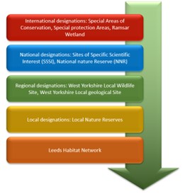
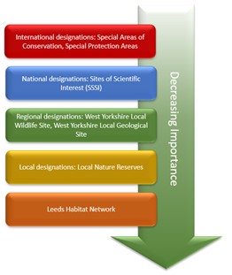
Nature Recovery Network and Local Nature Recovery Strategies
5.5.43 The 25 Year Environment Plan (2018) set out the Government's commitment to establishing a national Nature Recovery Network of wildlife-rich places across the country. This was enacted by the Environment Act (2021) and the key ambitions are to:
- enhance sites designated for nature conservation and other wildlife-rich places, including creating new wildlife-rich habitats, corridors and linkages and restoring damaged areas.
- improve the landscape's resilience to climate change, use natural methods to reduce carbon and manage flood risk, and preserve vital ecosystems such as clean water.
- reinforce the natural, geological and cultural diversity of the landscape and protect the historic natural environment.
- enable us to enjoy and connect with nature where we live, work and play which benefits our health and wellbeing.
5.5.44 Local Nature Recovery Strategies will be key to the protection and improvement of the natural environment and have been established to reverse nature's decline. Established through the Environment Act 2021, these spatial strategies will set out priorities and map proposals for specific actions by the public, private and voluntary sectors to drive nature's recovery and provide wider environmental benefits through local collaboration and partnership working. Local Nature Recovery Strategies (LNRS) will work with the funding mechanisms and decision making processes that will drive their delivery as well as other strategies and mechanisms such as Environmental Improvement Plans, Species Conservation Strategies, Protected Sites Strategies, cConservation cCovenants and the delivery of Biodiversity Net Gain.
5.5.45 As these are relatively new concepts, there is currently no LNRS in place for Leeds but it will be produced at the West Yorkshire level. Further guidance and regulations from the Government will give clarity and establish the process for the production and review of LNRSs. The Council will be actively involved in the preparation and delivery of the relevant LNRS for West Yorkshire and will be key in bringing together the aims and delivery mechanisms of the policies of the Local Plan and a future LNRS.
[New Policies G8A and G8B rReplace Policy G8 of the Core Strategy 2019
with new Policy G8A]
with new Policy G8A]
Policy G8A: Protection of Important Species and Habitats
(i) Development will not be permitted which would
cause
anyunacceptably harm, either directly or indirectly, to any sites designated ofinternational ornational, regional or local biodiversity or geological importance or unless it is clearly evidenced that such harm cannot be avoided by locating on an alternative site with less harmful impacts, can be adequately mitigated, or, as a last resort, compensated for.which would cause any harm to internationally designated sites, or would cause serious harm to any Habitat or Species of Principal Importance.
(ii) In considering development proposals affecting any designated sites and UK Biodiversity Action Plan Priority species or habitats, the needs of the development and the requirements to maintain and enhance biological and geological diversity will be assessed.
Development will not be permitted which would cause
significant harm, either directly or indirectly, to any sites designated of regional or local
biodiversity or geological importance or any Habitat or Species of Principal Importance unless it is clearly evidenced that such harm cannot be avoided by locating on an alternative site with less harmful impacts, can be adequately mitigated, or, as a last resort, compensated for.
(iii) In addition, particular account will be taken ofIn considering development proposals affecting any designated sites and/or Habitat or Species of Principal Importance, the needs of the development and the requirements to maintain and enhance biological and/or geological diversity will be assessed. Particular account will be taken of:
- The extent and significance of potential harm to the interest of any
international, national, regional or local site, or Habitat or Species of Principal Importance, and - Evidence demonstrating that the need for the development outweighs the importance of anyinternational, national, regional or local site, or Habitat or Species of Principal Importance, and
- The extent that any adverse impact could be reduced and minimised through protection, mitigation, enhancement and compensatory measures secured through planning conditions or obligations and which would be subject to appropriate monitoring arrangements.
- The submission of comprehensive and robust maintenance and management measures and a commitment to implement them.
- Any candidate potential sites for a Local Wildlife Site designation that have been assessed against recognised criteria and are awaiting formal designation or are clearly identified on an assessment work programme.
- The priorities of the relevant Local Nature Recovery Strategy for West Yorkshire and the national Nature Recovery Network.
(iv)
Any candidate/potential sites for a Local Wildlife Site or Local Geological Site designation that have been assessed against recognised criteria and are awaiting formal designation
will
be afforded the same level of protection as a designated Local Wildlife Site or Local Geological Site.
5.5.46 Designated regional sites are under continual review against recognised criteria. The regional West Yorkshire Local Wildlife Sites and West Yorkshire Local Geological Sites are reviewed through liaison with the West Yorkshire Local Sites Partnership. Using a robust, well established process, sites are identified, assessed against written criteria, designated and shown on the Policies Map and the Natural Environment Map and Schedule of
Nature ConservationdDesignated sSites available on the Council's website.
[Replace paragraph 5.5.30 as follows]
Leeds Habitat Network
5.5.47 Networks of natural and semi-natural habitats provide a valuable resource. They can link important biodiversity sites and provide routes or stepping stones for the migration, dispersal and genetic exchange of species in the wider environment. It is therefore important to avoid fragmentation and isolation of these habitats and to protect these areas from inappropriate, harmful development that results in significant adverse impacts. Lesser adverse impacts shcould be compensated forthrough enhancement and/or expansion of the Network.Carefully considered and designed development can potentially integrate with and positively strengthen the network of habitats. This will partly be achieved as part of the wider strategy for the protection and extension of Green Infrastructure, including open space and access routes such as canals and rivers, including those within the urban area and rural settlements.
5.5.48 The Leeds Habitat Network is shown on Map XX and the Policies Map and identifies a network of valued natural and semi-natural sites, from formally designated sites such as SSSIs and Local Wildlife Sites to areas identified locally as having habitat value. This Network is not static; indeed, monitoring and reviewing the network is important to its integrity and function and will be done through continued liaison with West Yorkshire Ecology and relevant local agencies. New sites identified through work such as neighbourhood plans will be added to the Network on a regular basis. Local extensions could be identified through Neighbourhood Plans, especially through the designation of local green space. The Leeds Habitat Network will be the primary focus for biodiversity improvements and the delivery of off-site Biodiversity Net Gain. It will alsoshould form a key component of the emerging Local Nature Recovery Strategy for West Yorkshire.
Leeds Habitat Network Map
[Insert new Policy G8B]
Policy G8B: Leeds Habitat Network
1.The Leeds Habitat Network, as designated through this policy
and shown on
Map XX and the Policies Map, identifies areas of wetland, woodland, heathland, grassland and other semi-natural habitats which have been recognised for their value to the natural capital of Leeds.
2. Any development proposals located within the Leeds Habitat Network must not result in significant adverse impacts on the value, integrity and connectivity of the Leeds Habitat Network. Any adverse local impacts should be compensated for by enhancements to, and/or the physical expansion of the Network.
3. Enhancement and expansion of the Network will be sought through measures that will contribute positively to the long term protection of those areas and improve connectivity of the Network.
Any
new
sites
delivered during the plan period
will be deemed to be part of the Leeds Habitat Network.
[Insert paragraphs as follows]
Biodiversity Net Gain
5.5.49 The Environment Act (2021) has introduced a mandatory requirement for
mostcertain developmentstypes to deliver of a minimum 10% Biodiversity Net Gain (BNG).
BNG means that biodiversity is measurably better off as a result of a development compared to the pre-development state. The Council supports BNG that is underpinned by the "Biodiversity net gain. Good
practice
principles for
development. A
practical
guide" (report ref. C776a2019 by CIEEM, CIRIA and IEMA), which sets an industry-standard and benchmark of what good BNG
should
look like.
Defra'sThe Biodiversity Metric is the nationally recognised tool to measure and quantify biodiversity on sites and will be used to assess initial biodiversity value, guide measures to deliver an improvement and assess the resulting post-development biodiversity value to ensure adequate gain is achieved.
The Biodiversity Metric requires the minimum 10% BNG to be delivered separately for all three types of habitats that may be present: Habitat Biodiversity Units; Hedgerow Biodiversity Units; and
Watercourse Biodiversity Units. It should be noted that
Watercourse Biodiversity Units include the 10 metre zone adjacent to the
watercourse, which therefore (for example) requires any development within 10 metres of the River Aire in Leeds City Centre to also apply the
Watercourse Biodiversity Metric.
The Environment Act (2021) requires BNG to be delivered for a minimum of 30 years and for any monitoring and reporting to be carried out for at least that length of time. Where the consented development lasts beyond 30 years then the BNG should also last beyond 30 years.
In order to assess and monitor success of any on-site BNG delivery there will be a requirement to submit progress reports on the management and habitat monitoring through planning conditions for the minimum period of 30 years, but the ongoing implementation of
a BNG Management Plan will be expected to continue beyond the 30 year period. The same applies to any off-site BNG delivery through a
s106 Agreement, which is used to secure the off-site biodiversity works i.e. the management progress reports and habitat monitoring will need to be submitted to the Council for the first 30 years but the ongoing implementation of the BNG Management Plan will also be expected to continue beyond the 30 year period to achieve a long-lastingbiodiversity gain
i.e.
at least
for the lifetime of the development.
In addition to the numerical calculation of BNG measured in Biodiversity Units, developments will need to demonstrate clearly how good design and protection of the natural environment have been at the heart of any scheme and that a professional ecologist has been instrumental in ensuring meaningful BNG will be delivered in a way that leaves a legacy for the natural world.
BNG will be delivered on-site unless robust evidence is submitted to demonstrate that this is not feasible. In such a case, off-site delivery of the required residual number of Biodiversity Units will be required. Off-site delivery of Biodiversity Units will only be considered acceptable as a last resort.
In cases whereby
delivery of
off-site Biodiversity Unitsis
considered acceptable (as a last resort) it is expected that it will be delivered by one of the following scenarios:
-
On land owned by the developer or other land which the developer has a legal interest in -
On private land -
On land registered with a private habitat bank -
On land owned by Leeds City Council or like-minded partners it chooses
to work with in the role of a habitat bank -
National Biodiversity Credits (only where none of the above options are available)
On-site Strategic Significance
The on-site location score for Strategic Significance in the Biodiversity Metric is based on the geographical importance of the site's biodiversity value. In Leeds the designated nature conservation sites are the most important locations for biodiversity, followed by the Leeds Habitat Network – which together also includes the largest and most important watercourse features in Leeds.
5.5.50 In addition to the numerical calculation of gain in biodiversity units, developments will need to demonstrate clearly how good design and the natural environment have been at the heart of scheme creation and a professional ecologist has been instrumental in ensuring BNG will be delivered.BNG will be delivered on-site unless robust evidence is submitted to demonstrate that this is not feasible.In this case, off-site delivery of the required residual number of Biodiversity Units will be required. Off-site delivery of Biodiversity Units will only be considered as a last resort.
Off-site Strategic Significance
5.5.51 It is important that when off-site Biodiversity Units are to be delivered this only takes place in locations that fulfil one or both of the following:
- best biodiversity outcomes, and/or
- wider society benefits of access to nature
5.5.52 As well as Tthe locations that provide the best biodiversity outcomes
(designatedare existing nature conservation designated sites and the Leeds Habitat Network), including newlandsites that provides the opportunity to create new connections and linkages thereby expanding the habitat network, theLeeds Habitat Network is also important. This approach is supported by the
"Making Space for Nature: A review of England's Wildlife
Sites and Ecological Network" 2010 by Professor Sir John Lawton (known as the Lawton Review) which seeks additional action to: increase the size and improve the quality of current wildlife sites,; enhance connections between sites,; create new sites; and reduce the pressure on current sites by improving the wider environment.
5.5.53 All applications delivering BNG should be accompanied with sufficient, high quality information to assess each application and allow monitoring and reporting of where Biodiversity Units are being delivered both on-site and off-site.This should include clear scaled maps showing not just the UK Habitat Classification land parcels before and after development but also annotated with where the Biodiversity Units occur on the same maps.
5.5.54 It is expected that this information will be contained within a Biodiversity Net Gain Plan report which will be submitted in support of a planning application Where on-site Biodiversity Units are to be delivered there will need to be a BNG Management & Monitoring Plan which clearly identifies which parts of the site it applies to.This may be addressed via a planning condition. The Council will have a duty to monitor the implementation of the Plan and enforce any non-compliance therefore only parts of the site that are accessible and outside of private ownership/curtilage should be shown to be included.Any areas not to be included in the BNG Management & Monitoring Plan should be excluded as contributing to BNG through any Biodiversity Metric calculations (such as private gardens).
Public access and new nature reserves
Where the
baseline biodiversity value of a piece of land chosen to deliver Biodiversity Units
is relatively low, the Council encourages good design of BNG delivery that can accommodate both improved biodiversity and better access for people. Wherethe size of such sites allows this should seek
the
establishment of new nature reserves both on-site and off-site.Parts of such sites
could be fenced
to restrict
public access
and
encourage ground-nesting birds
while
other parts of the site having appropriate infrastructure that can accommodate visitors in order to raise their awareness of the biodiversity near where
people live and work.
Many designated nature conservation sites have no public access and may be high value for biodiversity due to the lack of recreational disturbance – it is not the intention to encourage public access into such areas if this adversely impacts on the biodiversity value of that site.
Mitigation Hierarchy
5.5.55 Mitigation Hierarchy: The Council's approach to biodiversity will follow the mitigation hierarchy. This is a number of options ranked in terms of their desirability. iIt is as follows:
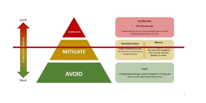
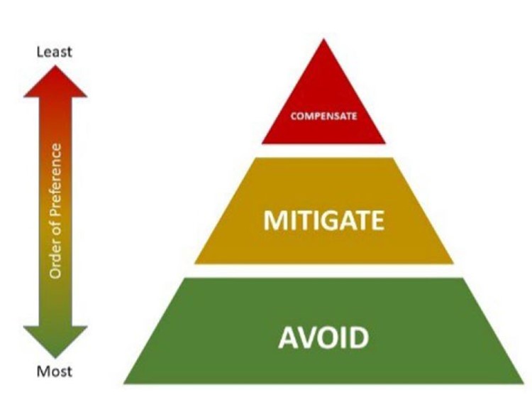
All applications for on-site and off-site BNG will be expected to submit
a reasoned justification for the measures proposed which considers the 10 BNG Principles set out in "BNG. Good practice principles for development. A practical guide" by Ciria 2019 (as updated). (on-site only)
accurate scaled drawings and GIS files showing where Biodiversity Units are to be lost and delivered
a BNG Management Plan that demonstrates:
how the uplift in Biodiversity Units will be delivered to achieve the target Condition
the cost of implementation of any biodiversity works including monitoring for a minimum 30-year period
who will be responsible for the creation and/or enhancement works and monitoring.
The Council wants to see retention of any valuable biodiversity features on-site and this means an evidence-based approach whereby any habitat that is defined in the Biodiversity Metric as Medium Distinctiveness (or higher) has been properly considered for retention. This will require input of an ecological consultant into the master-planning and design process. Where a Design & Access Statement is submitted it should include a section on BNG showing the different layout scenarios with such habitats retained in full and/or partially retained together with a rationale why this has not been considered feasible if they are shown to be removed in the proposed layout.
Any habitats that are Very High Distinctiveness (including Irreplaceable habitats) such as Ancient Woodland or Habitats of Principal Importance, should not be scored through the Biodiversity Metric. Policies G2B and G8a set outa strong presumption that any such habitats will be retained in full, and where loss is considered acceptable as a last resort there will need to be substantial bespoke compensation.
Disputes in application of the Metric
Where there is any dispute regarding the Habitat Type, Distinctiveness or Condition category score to be applied to any habitat, hedgerow or other linear feature the LPA may require an opinion from a different ecological consultant who is a member of CIEEM (Chartered Institute of Ecology and Environmental Management) or a Chartered Ecologist.
In relation to assigning the correct Habitat Type and Distinctiveness these should be based on the definitions in the UK Habitat Classification Version 2.0 (or any subsequent versions) and through use of the UK Habitat Classification Field Key.
Unless otherwise agreed with the Council, the Habitat Type category of Modified Grasslandshould only be applied to grassland according with NVC MG7 grassland (and some NVC MG6 communities) - which is reflective of agricultural pasture often with Perennial Rye Grass as the dominant grass species and/or recreational/amenity grassland such as sports pitches. Modified types of grassland are often regularly disturbed through repeated cutting and lack areas of vegetation left uncut (for structural diversity). NVC MG1 community grasslands should be classed as Other Neutral Grassland Habitat Types.
The Metric scores are a proxy and professional judgement is required to ensure the appropriate Habitat Type, Distinctiveness and Condition category is selected, which may require discussion with the Council's Nature Team.
Individual Urban and Rural Trees
Where new Individual Urban and Rural Trees of the Small or Medium Size class, as shown below in Table 8-1 (from The Biodiversity Metric 4.0 User Guide first published March 2023), are being proposed as part of the on-site or off-site BNG proposals there will need to be sufficient information to demonstrate the proposed trees will attain the specified target Diameter at Breast Height within the specified time range (within 30 years) and sufficient soil volumes and soil depthsfor the canopy spread at maturity. This information should be provided prior to determination to give assurance the associated numbers of Biodiversity Units can be delivered. Soil volumes should be calculated using the methodology in the LCC Guidance:Ancient Urban Tree Planting (SC Rev C-Dec 2018) and will need consideration of the potential canopy spread of the different tree species being proposed (which is available in the Trees & Design Action Group's "Tree Species Selection for Green Infrastructure: A Guide for Specifiers" Issue 1.3/2019).
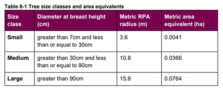
Watercourse Biodiversity Units
Rivers, streams and becks are examples of biodiversity features that are strategically valuable across a wider area than the Leeds District - being linked through their respective
Management and Operational Catchments, and this will be reflected
where off-site Watercourse delivery is required.
BNG information to be submitted
All applications delivering BNG should be accompanied with sufficient, high quality information to assess each application and allow monitoring and reporting of where Biodiversity Units are being delivered both on-site and off-site.
This should include clear scaled maps showing not just the UK Habitat Classification land parcels before and after development but also accurate, scaled maps of where the Biodiversity Units occur.
The required BNG information
may
be contained within a Biodiversity Net Gain Plan submitted in support of a planning application.
For both on-site and off-site delivery of
Biodiversity Units there will need to be an accurate, scaled map clearly showing which parts of the site will be covered bya BNG Management Plan and be subject to BNG Habitat Monitoring for a minimum of 30 years.
Under the Environment Act
(2021) the Council is expected to be the Enforcement body for implementation of BNG on-site. Therefore only parts of the site that are accessible (for the Council to monitor and enforce BNG delivery) and outside of private garden-space should be shown to be included in the BNG Management Plan.
In order to achieve a meaningful and long-lasting
BNG legacy,
any scoring areas (such as private gardens) not
covered by the BNG Management Plan and BNG Habitat Monitoring should be excluded as contributing to the 10% BNG – but can be included in the scoring to go beyond the minimum 10% BNG target.
BNG Monitoring and Reporting Body
Under the Environment Act (2021) the Council has a
responsibility
to monitor and report on the implementation of any on-site and off-site Biodiversity Units for the minimum 30 year period. This BNG Monitoring and Reporting Body
role
will ensure on-site and off-site BNG delivery is operating to the same standards. A charge will be put
in
place on all applications delivering off-site BNG to cover this
new
role provided by the Council, and will be available on the Council's BNG webpage.
A Biodiversity Net Gain SPD is to be produced to provide further detail on how on-site and off-site BNG will be delivered in Leeds. It is expected that secondary legislation for the Environment Act (2021)
will be produced prior to November 2023. It is also anticipated that a West Yorkshire Local Nature Recovery Strategy will be produced during the timescale of the Local Plan and may subsequently need to be reflected in the Strategic Significance aspects of the Metric calculations. The BNG SPD will make it clear how such changes and updates will be implemented in Leeds.
[New Policy G9 rReplaces Policy G9 of the Core Strategy 2019
with new Policy G9]
with new Policy G9]
Policy G9 – Biodiversity Net Gain
A) All new development will provide a minimum of 10% biodiversity net gain (BNG) in line with the Environment Act (2021) apart from the following types of development which are exempted from delivering 10% BNG
-
development impacting habitat of an area below a 'de minimis' threshold of 25 metres squared, or 5m for linear habitats such as hedgerows -
householder applications -
biodiversity gain sites (where habitats are being enhanced for wildlife)
Small scale self-build and custom housebuilding.
All three separate types of Biodiversity Units (Habitats, Hedgerows and Watercourses) which are present must demonstrate a 10% BNG.
The Watercourse Biodiversity Metric will need to be used where covered culverts or any land within 10 metres of a watercourse is part of the application.
The presumption is for BNG to be delivered on-site. Off-site delivery will only be acceptable where there is clear evidence that the mitigation hierarchy has been applied to the satisfaction of the Local Planning Authority (LPA).
Proposed Individual Trees need to be accompanied with sufficient technical informationper tree to demonstrate the Diameter at Breast Height at 30 years and soil volumes and soil depth to achieve their potential canopy spread.in line with the "Tree Species Selection for Green Infrastructure: A Guide for Specifiers Issue 1.3/2019" by the Trees & Design Action Group.
Implementation of all on-site and off-site BNG delivery will be monitored by the LPA through its role as the BNG Monitoring & Reporting Body.
B) On-site BNG Delivery
On-site Biodiversity Units that are Medium or High Distinctiveness should be retained in full and enhanced unless it is clearly demonstrated and justified by an appointed ecological consultant to the satisfaction of the LPA that the mitigation hierarchy has been fully considered through a range of costed options that includes retention of these habitats.
Strategic Significance for the development site will be calculated as follows:
-
High = Nature Conservation Designations and Leeds Habitat Network - Medium = Immediately adjacent to the above locations
- Low = Anywhere else in the District
Where they occur on-site, any covered sections of water courses should be re-opened and any artificial water channels re-naturalised to contribute to delivery ofWatercourse Biodiversity Units.
Private garden space is not considered reasonable by the LPA to be deliverable through a BNG Management Plan and therefore will not be considered to contribute to the minimum 10% BNG target Metric calculations. Any such areascan be scored but will need to contribute to above the 10% BNG target.
Any land to be in private ownership or other land that it is not considered reasonable by the LPA to enforce compliance in accordance with the BNG Management Plan will be scored as zero value in the Biodiversity Metric calculations.
All applications delivering on-site BNG will provide:
- a reasoned justification for the BNG proposed
-
how all 10 BNG Principles set out in "BNG: Good practice principles for development. A practical guide" by CIEEM, Ciria and IEMA 2019 (as updated) have been met - full Spreadsheet Biodiversity Metric calculations
-
accurate, scaled maps
and GIS data
showing parts of the site:
i. where Biodiversity Units are to be lost
ii. where Biodiversity Units are to be delivered
iii. where Biodiversity Units are to be retained and/or enhanced and protected through the construction phase - the habitat creation and/or enhancement and management actions to deliver the uplift in Biodiversity Units to achieve the stated target Conditions
- who will be responsible for funding the: initial creation, establishment and/or enhancement works; long-term management works; and habitat monitoring. And what will be
- the projected cost for implementing the first 5 years of: the BNG Management Plan after any creation and establishment works,; and habitat monitoring
- who will be responsible for implementing the: initial creation and/or enhancement; long-term management works; and habitat monitoring
- whether any off-site Biodiversity Units are intended to be purchased from a Habitat Bank or other third party or national statutory credits
iv. to be covered by a BNG Management Plan and BNG Habitat Monitoring
Where Biodiversity Units are to be delivered on-site,
a planning condition will be used to ensure
approval of: a BNG Management Plan; annual management progress reports for the first 5 years; updated BNG Management Plan every 5 years with a progress report; and habitat monitoring
reports
for a minimum 30-year period to the LPA
providing the BNG Monitoring and Reporting Body role. All Biodiversity Units delivered as part of the minimum 30-year period will be retained thereafter for the lifetime of the development.
Prior to
determination, Outline applications will need to carry out Baseline and Post-Development Metric calculations based on an indicative layout in order to demonstrate that a minimum 10% BNG can be achieved on-site. Where 10% BNG can not be demonstrated as deliverable on-site there will need to be an appropriate off-site area of land identified and proposed biodiversity works agreed with the LPA prior to
determination.
details of where Biodiversity Units are to be lost and delivered
An outline BNG Management Plan.
c) Off-site BNG Delivery
Subject to the agreement of the LPA, any required residual number of
Habitat, Hedgerow or Watercourse Biodiversity Units will be delivered off-site in the same locality and in one of the following
biodiversity priority locations (in decreasing order of preference):
1 Within or immediately adjacent to a
designated nature conservation site or Habitat orf Principal Importance (as per Policy G8a)
(= High
sStrategic Significance)
West Yorkshire Local Wildlife Site or Local Nature Reserve
2 Within or immediately adjacent to the Leeds Habitat Network (= Medium Strategic Significance)
3 Outside the Leeds Habitat Network but in a location that forms a new strategic connection between two separate parts of the Network (= Low Strategic Significance)
4 Any other location but with clearly defined public access to provide the function of a nature reserve (Habitat and Hedgerow Biodiversity Units only)(= Low Strategic Significance)
If no suitable sites can be identified
in the same locality, sites within the wider Leeds District that meet wider biodiversity objectives and are in one of the
biodiversity priority locations (in decreasing order of preference) set out above can be considered.
5 Any other location (Watercourse Biodiversity Units only)
inside the same
Management
Catchment
area
(but
which can be outside the Leeds District) = Low Strategic Significance
All applications delivering off-site BNG will provide:
1. full Spreadsheet Biodiversity Metric calculations
2. details of where Biodiversity Units are to be delivered
including accurate scaled maps and GIS data
3. accurate scaled drawing of parts of the site to be covered by a BNG Management Plan and BNG Habitat Monitoring
4. the habitat creation and/or enhancement and management actions to deliver the uplift in Biodiversity Units to achieve the stated target Conditions
5. who will be responsible for funding the: initial creation and/or enhancement; long-term management works; and habitat monitoring
6. who will be responsible for implementing the: initial creation and/or enhancement; long-term management works; and habitat monitoring
7. whether any off-site Biodiversity Units are intended to be purchased from a Habitat Bank or other third party
Unless otherwise agreed by the LPA as106 and/or Conservation Covenant will
need to
be
put in place to ensure submission of: a BNG Management Plan; annual management progress reports for the first 5 years; updated BNG Management Plan every 5 yearswith a progress report; and habitat monitoring
reports
for a minimum 30-year period to the LPA as the BNG Monitoring and Reporting Body. All Biodiversity Units delivered as part of the minimum 30-year period will be retained thereafter for the lifetime of the development.
2.
8. An outline BNG Management Plan
Species Biodiversity Enhancements
Policy G9 (BNG) only applies to habitat enhancements for biodiversity andthe Biodiversity Metric does not try to assess the value of any site for species
even though
development can impact species as well as habitats.
It is important to
understand any adverse impacts on species resulting from development
should be assessed through submission ofan Ecological Impact Assessment, and
planning conditions may be used to
ensure impacts are minimised and enhancements agreed.
In recognition of the importance of species in
securing biodiversity enhancementdevelopment
will be expected to incorporate
features and infrastructure that will benefit species such as through newintegral
bat roosts,
integral
swift bricks, bee bricks and hedgehog highways.
All new build
and alteration schemes
should provide
integral
features for bat roosting and
integral
Swift Bricks. Details of these features (e.g. how many, where, specifications of features) should be submitted prior to determination in the Ecological Impact Assessment (EcIA) report and on a General Layout type drawing to ensure the housebuilder does not overlook them.
For outline applications, there should be a commitment to providing integral bat roosting and integral Swift Bricks together with an indication of how many.
An appropriately qualified ecological consultant
should be appointed to assess the site and types of buildings in order to put forward a scheme that has the highest chance of being successfully used by locally occurring species of bats and birds. Considerations need to include: height of feature; aspect of the building; avoidance of external lighting; no windows or doors below.
The appointed ecological consultant must liaise with the relevant building architect to confirm the specification of bat roosting/bird nesting feature is suitable for the building materials being used. Any such features installed into Listed buildings and other Listed structures must be sensitively designed to not detract from the architectural/cultural features of interest (separate Listed Building consent may be required if the impact is more than de minimis). Installation
should follow best practice guidance where possible.
[Insert new Policy G10 - Biodiversity Enhancements for Species]
Policy G10 - Biodiversity Enhancements for Species
All development should provide biodiversity enhancement for species commensurate with the scale of development.
All Minor and Major development which consists of new buildings or works to existing buildings should provide integral bat and/or integral Swift nest features as per the following requirements:
-
Residential schemes (apart from flats): a minimum of 3 features and a minimum ratio of one feature per number of dwellings whichever number is the greater -
Residential flats and non-Residential schemes: a minimum of 5 features for the first 1000m² footprint and one additional feature for every additional 100m²
The specification of features and their location should be submitted to, and approved by, the Local Planning Authority
Local Food pProduction
5.5.56 The Climate Change Emergency, recent pandemic and subsequent cost of living crisis has brought into sharp focus the importance of food security and fFood system rResilience. As a society we are much more aware factors such as the distance food travels, its availability, its quality and its cost impact on our lives on a day to day basis particularly with regard areas of deprivation and malnutrition.
5.5.57 It is recognised that all the residents of Leeds should have sustainable and economic access to healthy and nutritious food that meets their needs for an active and healthy life without compromising the Climate.
5.5.58 The mitigation of the issues highlighted above through the Planning process will take a multi-faceted approach (although this will be limited by the remit of Planning legislation).
5.5.59 Leeds recognises that it has a supply of previously developed land (brownfield sites) and access to potential geo-thermal energy (old mine shafts) both of which can be used for possible food growing using modern hi-tec food growing techniques. Any use of such sites will be supported by Policy F1. It is recognised that the ability to access cheap healthy food locally is a cornerstone of food system resilience and therefore contributes to mitigating the problems associated with food security which can be particularly acute in areas of high deprivation. Locally sourced free food such as Forest Gardens, Community Gardens or Allotments have the benefits of:
- Providing free local food
- Reconnecting the public (particular children) to food
- Mental health benefits
- Community benefits
- Physical health benefits
- Require little maintenance
- Mitigation of Urban Heat Island (UHI) effects
- Biodiversity net gain benefits
Policy F1: Food System Resilience
To support food
system resilience andfood security, Leeds will:
- Support food growing and the necessary associated infrastructure, throughout the District
- Encourage farming and food production practices that support a low carbon approach including movement of food.
- Encourage farming and food production practices that promote greater Biodiversity and re-naturalisation of land.
- Support modern food production methods in suitable locations including (where balanced with other priorities) within the urban area, on brownfield sites and in vacant premises and where low carbon and renewable heat and power can be sourced.
- Support community food growing.
- Support residential development to reserve and create on-site opportunities for community food growing for residents and the local community as part of their GBI assessment
- Require that the residential developments with private gardens shall be required to provide at least 1 semi-mature fruit tree per garden and should explore opportunities to plant semi-mature fruit trees under policies on new greenspace and GBI.
Place Making
[The following new Policy SP1A will be inserted after Policy SP1 and paragraph 4.1.15 and before 4.2 of the Core Strategy 2019. It will delete Policy H2 and make a consequential change to existing Policy SP1: Location of Development]
Achieving 20 complete, compact and connected placesMinute Neighbourhoods in Leeds
4.1.16 Complete, compact and connected places is based on the 20 Minute Neighbourhoods[7] is a concept, which is used to plan for towns and cities where people can access their essential daily needs within a walkable/wheeled distance from their home. This includes access to key features such as shopping, recreation and leisure activities, schools and local services such as GP practices. In 2022, more people work from home (mainly as a result of the Covid-19 pandemic and increasing digital connectivity) and are more likely to access local hubs or businesses. Access to work and services beyond their neighbourhood and local needs should be focused on using public transport connections.
4.1.17 The original 20 Minute Neighbourhood principle (in 2016) was that any city's residents should be able to access their daily needs within a 15-minute walk or cycle ride, to reduce the redundancy of spaces that were far apart and infrequently used. The idea has been implemented in Paris and promoted by C40 Cities, a network of major cities around the world to tackle climate change. Since the COVIDCovid-19 pandemic, the concept has gained further popularity as a means of recovering urban economies and producing more resilient neighbourhoods. Achieving complete, compact and connected places is an aspiration of the Council, because it brings together a wide range of policies for sustainable development that align with its Best City Ambition. The policy sets out all of the aspects of a complete, compact and connected place, which will help to guide new development allocations in the District. However, it is recognised that not all existing places will be able to meet all of these characteristics because of the existing patterns of development and levels of services.
4.1.18 Research shows that the maximum time people are willing to walk/wheel to meet their local daily needs is 20 minutes. This represents an 800 metres walk to a destination and back again. Or 10 minutes' walk out and 10 minutes back to home. However, the context of different needs in our communities as well as varying neighbourhoods means we need to consider places individually. The roles of cities, town centres, urban suburbs and rural areas will be different. This means the focus should be on integrating the key features to allow people to live locally rather than focussing exclusively on the 20 minute aspect, giving people the ability to meet most of their daily needs within a 20-minute return walk/wheel from home and with access to safe cycling and local transport/shared mobility alternatives to access facilities that are not within 20 minutes. Core Strategy aims around active travel and public transport align with the Connecting Leeds Transport Strategy; building neighbourhoods with the critical mass to support public transport.
4.1.19 A '20 minute neighbourhoodcomplete, compact and connected place'scenario is one with higher density, mixed use development that targets access to public green space, a range of affordable house types, public transport and active travel. It is estimated this may require an average density of at least 65 dwellings per hectare in new developments, although it could be higher in some areas. It is intended to provide the most effective use of land, with an emphasis on brownfield sites. Higher densities help provide a critical mass to support existing and new local services and amenities. In turn this mixed use local areas can help reduce car usage. This also encompasses the Core Strategy's aims to improve housing availability, affordability, type and mix. High density does not mean high rise and can be provided by a mix of flats (5-6 storey) terraces (2-3 storey) as well as semi and detached houses. Higher density development can create the demand for associated services and business, employment and public transport, with local services within a 15-20 minute walking/wheeled distance at most and an emphasis on active travel. It can also allow for greater clustering of quality open space as part of a more efficient use of land.
4.1.20 Delivering high density development without ensuring provision of services and amenities within easy walking distance would have negative impacts on residents. It is important that services and infrastructure, including active travel infrastructure, are in place before residents move in. It is also important to consider the context of each individual development – the needs of city centre developments will differ from those nearer the outskirts of the city or in rural areas. The density standards set out in Policy H3 are minimum densities, but in order to achieve the 20 minute neighbourhood walkable and wheelable places principles it is recognised that residential densities may need to be higher. However, the Core Strategy is not prescribing what these should be. Rather, it is likely that the minimum Policy H3 densities will need to be exceeded when the placemaking policies of the Local Plan Update are implemented. Further monitoring will be carried out to provide future guidance on densities as part of the Authority Monitoring Report and the Council will set more detailed density expectations in Development Plan Documents, whichwhen allocatinge land for housing.
4.1.21 Higher density neighbourhoods could support more frequent public transport services, car clubs and bike share schemes and so are much less likely to be car dependant. These are all particularly important for people on low incomes. Critical mass could support shared workspaces, which may become important if fewer people want or need to commute to centrally located offices. Higher densities could also support more specialist services for people with particular needs.
4.1.22 Higher density and mixed uses may provide more opportunities for passive surveillance, but design is also important to achieve this. Traditional low density developments are more likely to encourage car ownership and use. Distances and homogeneity of land use mix are likely to discourage active travel and low density developments are less able to sustain frequent public transport services. Increased reliance on cars reduces physical activity and also has wider impacts on people living nearby and on commuting routes. Higher volumes of traffic increase air pollution, noise, injuries and severance.
4.1.23 Through the Connecting Leeds Strategy, Leeds has adopted a vision to be a City "where you don't need a car" and where priority is first given to pedestrian and cycle movements. Transport currently contributes up to 40% of carbon emissions in Leeds, so to meet the targets set in Policy SP0 action is required to reduce these emissions. The City Council encourages the uptake of zero emission vehicles and a modal shift away from private vehicles, which in-turn will reduce the number of vehicles in the District. At the same time, current levels of public transport infrastructure investments alone are unlikely to deliver sufficient incentives to significantly change behaviours or deliver the desired modal shift to reduce carbon emissions.
4.1.24 Whilst planning has a role in the creation of complete, compact and connectedplaces 20 min Neighbourhoods their successful creation of 20 min neighbourhoods goes beyond planning with reliance on otherssectors including Highways and active travel interventions and investment, Public Transport, Public Health, investors, regeneration and community ownership. The Council will work with other community partners to ensure that planning policy supports, and is supported by, other strategies in the city to support the needs and wellbeing of the population. This includes guidance, policies and an action programme that pro-actively promotes measures that reduce the need for private car use and ensures everyone in the city has accessconnection to accessible, affordable, integrated public transport and ensures a safe, connected green active travel network in the city.
What are daily needs and local services?
4.1.25 There are a range of core amenities that are considered essential for sustainable and local neighbourhoods. Such amenities include local shops, early years education, doctors, green spaces (including, playgrounds), social infrastructure and community facilities including community halls and public transport stops. The range of uses considered and that have been weighted in the mapping of Leeds are listed below in table 'LPU 4':
Complete, Compact and Connected - Services and Facilities Expectations
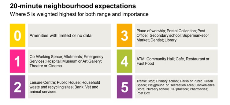
Table 'LPU 4'
4.1.26
For mapping purposes,
Leeds has been divided in equally sized hexes (measuring
circumradius/circumdiameter of 200m/400m).Based on the assigned weightings, the total achievable score for any hex (shown on Map 'LPU 5' below) is 18.The outputs are presented by their total weighting score, underpinned by a series of individual scores associated with individual amenities. This means that any hex can be analysed to understand the extent to which services are accessible
by walking/wheeling. The Hex Maps will be kept up to date (on an annual basis) and published online on the Councils webpages.
Hexes shaded darker red on this map are those with higher overall accessibility scores, meaning that a greater range of services are accessible within a 20-minute return trip on foot.The scale graduates through orange and yellow shades for lower accessibility scores, through to dark blue for areas with the least number of accessible amenities.
4.1.27 Based on the scale of 0 – 18 from the accessibility analysis, simple classifications have been defined (shown on Map 'LPU 6' based on dividing the scores into quarters so that:
- Walkable neighbourhood (75-100%) (Score 13.5 – 18) with majority of essential and desirable facilities within walking distance.
- Good accessibility (50-745%) (Score: 9 – 13.49) Many essential and desirable facilities within walking distance but some journeys require a longer trip.
- Limited accessibility (25-4950%) (Score: 4.5 – 8.99) Some essential or desirable facilities within walking distance but most journeys will require a longer trip.
- Poor accessibility (0-245%) (Score: 0 – 4.49) Very limited number of essential and desirable facilities within walking distance
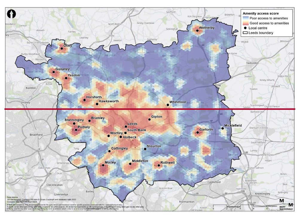
Map 'LPU5': Leeds 20-minute neighbourhood accessibility mapping
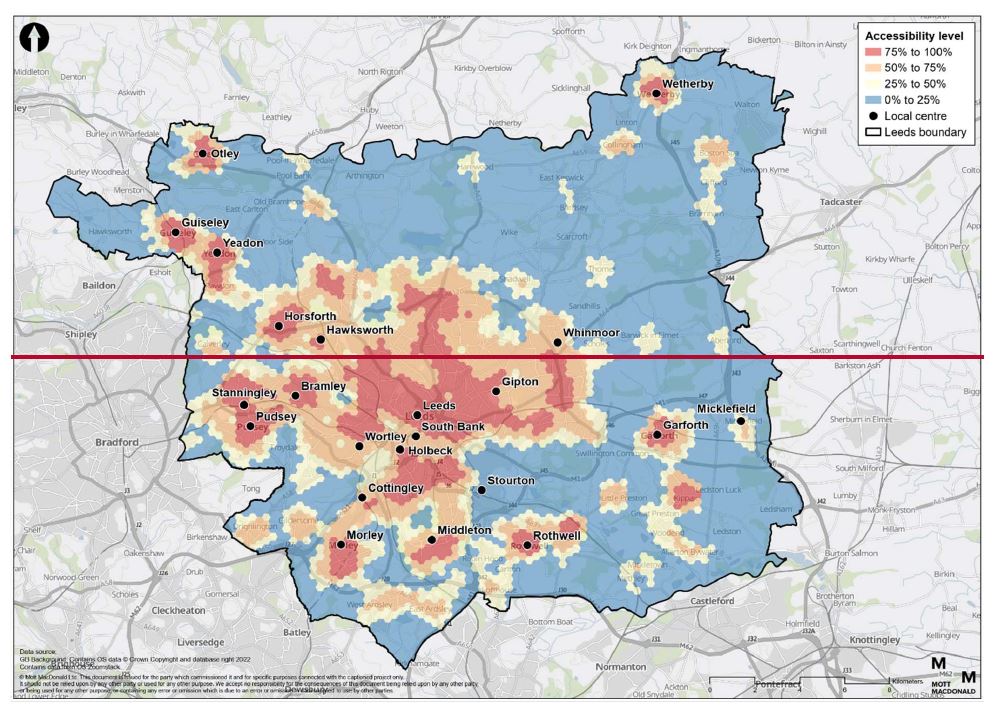
4.1.28 Policy SP1A uses the principles of
complete, compact and connected places (20 minute neighbourhoods) to help guide the location of also considers how housing developments are to be permitted on land that was too small to allocate or becomes available unexpectedly (windfall). It concerns the principle of housing development rather than details which may be controlled through other Policies. For example, development of a residential garden for housing would depend on how much the garden contributes to the GBI, green
infrastructure, visual and spatial character of an area, not on the quality of design which is the domain of Policy P10. Policy SP1A reads alongside other policies
in the Leeds Local Plan to assist in the balance of considerations of
high-quality development in sustainable places.
Policy SP1A - Achieving 20 Minute Neighbourhoods in Leeds Complete, Compact and Connected Places
i) To improve liveability (living locally) across the communities of Leeds the focus of new development should be to meet the principles of complete, compact and connected places 20-minute neighbourhoods.
ii) A Complete, compact and connect place 20 minute neighbourhood in Leeds is one that:
i. Delivers development that maximises densities (unless there are overriding reasons concerning townscape, character, design and environmental impact) to support a critical mass for multiple local services/facilities and the viability of public transport, and
ii. Provides at least good accessibility* to a range of local services/facilities within a 10-minute walk [*as defined by paragraph X above]
iii. Is safe, secure, pleasant, and well connected for pedestrianswalking, wheeling and
cycling cyclists and optimises active transport; and
iv. Facilitates safe and easy access to quality public transport that connects people to jobs and services/facilities further away, and
v. Offers high-quality public realm and open greenspaces with emphasis on inclusion, local play and nature connectedness, and
vi. Provides services and destinations that support healthy local living, and
vii. Delivers a mix of housing types and range of affordable housing types to support a diverse population mix, allowing for more resilient, multi-generational communities that support our ageing population to age in place, and
viii. Encourages mixed uses and innovative and flexible design of buildings and spaces to provide multifunctional uses to facilitate thriving local economies and inclusion; important for sustaining a wider range and level of services and infrastructure as well as creating a sense of place with a recognisable centre and identity.
iii) Under the terms of this policy
windfall housing development (5 or more units) will be acceptable in principle on non-allocated land, providing that:
a. the site is located in those parts of the district that demonstrate the functionality of acomplete, compact and connected place 20 minute neighbourhood as defined above, or
b. development can clearly address how deficiencies in accessibility to services/facilities will be met (and delivered), and
c. The number of dwellings does not exceed the capacity of transport, educational and health infrastructure, as existing or provided as a condition of development, and
d. Green Belt Policy is satisfied for sites in the Green Belt and
e. Areas of high flood risk to be avoided, and
f. Greenfield land should not be developed if it has intrinsic value for:
i. amenity space for recreation
ii. nature conservation
iii. makes a valuable contribution to the visual, historic and or spatial character of and area
iv. can contribute to the adaptation to climate change especially in inner urban parts of the City where the capacity to deal with climate change is low.
iv) All proposals will be required to accord with Policy T2 and accessibility standards.
[Amend Policy SP1 of the Core Strategy as indicated by words in bold italics]
Spatial Policy 1: Location of Development
To deliver the spatial development strategy based on the Leeds settlement hierarchy and to concentrate the majority of new development within and adjacent to urban areas, taking advantage of existing services, high levels of accessibility, priorities for urban regeneration and an appropriate balance of brownfield and greenfield land, the distribution and scale of development will be in accordance with the following principles:
The largest amount of development will be located in the Main Urban Area and Major Settlementswhere development can deliver the principles of 20min neighbourhoods.
Smaller Settlements willonlycontribute to development needs, if they can demonstrate that development has the ability to deliver the principles of 20min neighbourhoods or where development is small scale i.e. less than 10 dwellings
III.In applying (i) AND (II) above, the priority for identifying land for development will be as follows:
a. Previously developed land and buildings
b. Other suitable infill sites,
c. Key locations identified as sustainable extensions,
[… remainder of text unchanged BUT RENUMBERED]
[The following new explanatory text and policy will be inserted after policy EN8 of the Core Strategy 2019]
Reducing Car Dependent Development
Through the Connecting Leeds Strategy, Leeds has adopted a vision to be a City "where you don't need a car" and where priority is first given to pedestrian and cycle movements. Transport currently contributes up to 40% of carbon emissions in Leeds, so to meet the targets set in Policy SP0 action is required to reduce these emissions. The City Council encourages the uptake of zero emission vehicles and a modal shift away from private vehicles, which in-turn will reduce the number of vehicles in the District. At the same time, current levels of public transport infrastructure investments alone are unlikely to deliver sufficient incentives to significantly change behaviours or deliver the desired modal shift to reduce carbon emissions.
Section 4.0: Planning for Climate Change outlines the ambitions for aiming for net zero by 2030. Related to thisCcar-dependent development can result in poor air quality, congestion and increased carbon emissions which impede the ability of the Council to deliver the targets in Policy SP0. There are circumstances where car dependent developments, such as drive-thrus have increased levels of nitrogen dioxide and particulate matter due to vehicle idling which can have significant impacts on health. There may be circumstances where new applications for drive thru's and petrol filling stations with shopping and eating facilities (defined as a main town centre use in the NPPF) might be supported, but they should be located within designated centres, on the edge of centres or when located in other commercial centres, or adjacent to existing facilities well served by public transport to support opportunities for modal shift away from the private car.
The overall policy ambition is to avoid reliance on the private car and create a compact, accessible, and connected city. Therefore, and operating alongside national guidance and Core Strategy policy on town centres and retail uses, the following policy is necessary. will operate alongside national guidance and Core Strategy Policy on Town Centres and retail uses.
Policy EN9 – New Drive Thru' Development
To support Leeds's zero carbon by 2030 ambition and improve reduction in car dominated travel and improve air quality, planning permission for drive thru's will only be granted where at least one of the following criteria is met:
a. The proposal is located within or on the edge of local or town centres in accordance with policies P2 and P3 and/or
b. The proposal is located with other commercial centres/existing facilities well served by public transport 1 See Policy T2 on accessibility standards.
1 see Appendix 3:Table 1 Accessibility Standards
[The following explanatory text and new policyies will replace Core Strategy Policy P10 and UDP Policy GP5
to be inserted after para 5.3.40with a new Policy SP1B to sit after follow new paragraphs and Policy on
complete, compact and connected places 20-minute neighbourhoods to be inserted after 4.1.15 and before 4.2 of the Core Strategy]
Design
4.1.29 High quality design is a key aspect of, alongside sustainable and resilient development,and is essential in creating places in which current and future generations can enjoy a high quality of life which is fulfilling and healthy. Good
High Quality design goes beyond aesthetic considerations and should address the connections between
form and function, people and places and the integration of new development into the built and natural environment. Design is at the forefront of issues such as climate change, energy use, car dependence, community cohesion and health and wellbeing. The vast majority of people who live and work in the Leeds City Region do so in an urban environment. Their quality of life of
people who live and work in Leeds relies heavily upon the quality of their environment. In order to continue its economic success in a sustainable manner, and in order to achieve its aim of being the Best City in the UK by 2030, Leeds must build upon and retain the high quality of its built, historic and natural environment.
4.1.30 High quality and well-designed sustainable places are sought in Leeds which seek to achieve:
a. form, function and aesthetics appropriate their location
a.b. Climate change mitigation
c.b. Adaption to climate change
cd. Health and well-being
de. Community cohesion
ef. Inclusive growth
fg. Accessibility and inclusion
g.h. Protection and enhancement of Leeds's natural and historic assets
4.1.31 Development requiring planning permission will be subject to development control considerations, including the acceptable provision of vehicular access, surface and foul water sewer disposal, car parking, greenspace, landscape and detailed design considerations. Landscaping concerns will include the retention of trees. Development proposals may be submitted for planning approval in two ways. Outline applications need to resolve those requirements which establish in principle whether a site is physically developable for the development intended. Detailed applications need to resolve all development control considerations
There are a variety of issues that require consideration at the outset of the design process which include but are not limited to; context and character, natural environment, scale, mass, integration with existing communities and neighbourhoods, designing out crime; disabled access; the orientation of buildings to address amenity issues such as air quality, daylight, noise and privacy; waste and recycling storage; and car and cycle parking. These considerations are set out across the Local Plan and in particular Policy P10.
4.1.33 Developers are required to cross reference other Local Plan Policies on relevant issues such as flood risk mitigation, renewable energy measures and sustainable construction
and Green & Blue
Infrastructureetc to ensure that they are integral to the design process. Guidance on the achievement of these requirements or provision of facilities may be set through area or site development frameworks, Neighbourhood Plans, Supplementary Planning
Documents or Guidance, planning briefs and frameworks or
Ddesign
Ccodes. Leeds has a range of Supplementary Guidance and SPD's that support design Policy P10 including Neighbourhoods for Living; Tall Buildings Strategy; Building for Tomorrow Today; Householder Design Guide and a wealth of Village and Neighbourhood Design Statements. Neighbourhoods for Living contains principles and process guidance which should be used to lead to excellence and responsive design.
4.1.34 Inconsidering internal and external accessibility and inclusion the British Standards BS8300:2018 'Design of an accessible and
inclusive built environment. Buildings – code of practice
(or
latest version)
should be used. This
provides recommendations on inclusive and accessible design of buildings and the spaces within them and
covers development of inclusive design strategy; strategic site and building layout; arriving at a destination and parking; access routes to and within buildings; entering a building - doors, access control systems, entrance and reception areas; horizontal movement - corridors and passageways; vertical movement - steps, stairs, ramps, slopes, handrails, lifts; surface finishes; provision of signs and information; audible communication systems; lighting; facilities in buildings - seating, storage, windows, building services, assistance dog toilets; counters and reception desks; audience and spectator facilities; sanitary accommodation - showers, baby changing, toilets; individual rooms - kitchens, bedrooms, quiet spaces; and various building types.
4.1.35Investigations may also be needed to assess land stability and whether proximity to hazardous installations or pipelines will constrain development. Sites may also need to be subject of stability investigations. Development should reflect the concepts of sustainability.
Policy SP1B: Achieving Well-Designed Sustainable Places
1.All development in all parts of Leeds will be required to achieve high quality design that is reflective of a thorough contextual analysis and understanding of the scheme within the surrounding area and where appropriate, through community consultation. High quality, sustainable and well-designed places will be achieved in all parts of Leeds by taking a proactive and collaborative approach at all stages of the planning process for all new development. This will be achieved by new development proposals ensuring that:
i. A thorough understanding, appraisal and assessment of the site and its context (including local character and landscape) is undertaken prior to the start of the design process and submissiontting of a planning application.
ii. Development proposals for new buildings/uses, routes and spaces, and alterations/extensions, should minimise carbon emissions and be able to adapt to climate change and be appropriate to its location, scale, form (including massing and appearance) and function
iii. Development proposals should address access, drainage, contamination, stability, landscaping and design
iv. Development Proposals should address internal and external accessibility and inclusion for all
v. Development proposals should seek to avoid problems of environmental harm, loss of natural features, loss of amenity, pollution danger to health or life, and highway congestion, to maximise highway safety (vision zero), minimises carbon emissions and the prevention of crime
[The following explanatory text and new policy will replace Core Strategy Policy P10 to be inserted after para 5.3.40]
5.3.42 Leeds has a rich and diverse urban
and rural environment. It ranges from leafy suburbs, rural villages, to free standing market towns, industrial settlements, inner urban areas and a vibrant City Centre. Excellent
high
qualityUrban Design including the provision of works of art or craftsmanship thatenhance buildings and their surroundings can reinforce the distinctiveness of these unique and special places and contextual analysis, it should inform opportunities for contextual development that to enhances our City as a whole. An overarching aim is to create and sustain people-friendly places for the benefit of the residents and businesses of Leeds, whilst endeavouring to support developers seeking to deliver the highest quality design solutions. As such, it is important that the views of local communities are captured through the development process, including through engagement with major developments at an early stage of the planning process.
Leeds also has a rich and varied natural landscape. The natural environment gives space for Leeds' residents to engage with nature, recreation and sports, benefitting their health and wellbeing. The natural environment also supports biodiversity, providing space for flora and fauna, natural shade and cooling, it removes CO2 from the atmosphere, all of which is ever more important as we tackle the impacts of climate change. Design in Leeds shall minimise harm to the natural environment by controlling and mitigating unavoidable impacts, by integrating with the natural environment and offering space for flora and fauna on development sites.
5.3.43 The City Council has a long-standing commitment to delivering excellenthigh qualityurban design. This is reflected in the Ten Urban Design Principles (adopted by Executive Board in January 2005) as a basis to inspire and enhance the design quality in Leeds and provide a robust framework for creating successful places at all levels. Together with early stakeholder working in the form of design workshops and consultation (as is set out in the Statement of Community Engagement), investing in goodhigh quality urban design can create economically successful development that functions well and has a lasting effect now and into the future.
The Council is keen to encourage the provision of works of art or craftsmanship that enhance buildings and their surroundings. Such works might include decorative ironwork, paving, sculpture, or many other forms. This is particularly appropriate to buildings used by the public and for large scale developments.
[The following policy is going to delete existing Core Strategy 2019 policy P10 and UDP policy GP5]
Policy P10: Development Principles for High-Quality Design & Healthy Place Making
All development will be required to achieve high quality design that is reflective of a thorough contextual analysis and understanding of an area and where appropriate, through community consultation.
Development proposals for new buildings, routes and spaces, and alterations to existing, should minimise carbon emissions and be able to adapt to climate change (through relevant Local Plan policies) and be appropriate to its location, scale, form (including massing and appearance) and function
Development proposals should address access, drainage, contamination, stability, landscaping and design
Development proposals should seek to avoid problems of environmental harm, loss of natural features, loss of amenity, pollution, danger to health or life, and highway congestion, to maximise highway safety, minimises carbon emissions and the prevention of crime.
All development shall be inclusive and accessible to all users.
All development will therefore be expected to:
In accordance with Policy SP1B: Achieving well-designed and sustainable places; all development will be expected to:
Context
1. Contribute positively to an area's character and identity, creating high quality design that reinforces local distinctiveness with respect to existing landscapes, natural features, boundaries, topography, waterscapes, streets, spaces, buildings and, materials and incorporate craftmanship and public art.
Existing Assets
2. Preserve or enhance the district's existing historic and natural assets, in particular, historic and natural site features and locally important buildings, spaces, skylines and views. and Mmaximise the potential contribution towards addressing climate change and improving air quality by capitalising on opportunities to re-use existing buildings and structures. Development should augment existing, and create new green
and, blue and open infrastructure (such as additional planting, hedges, green roofs/walls, street trees, integrating flood alleviation and drainage measures,) linked to corresponding features beyond the site boundary, where applicable
and will be expected to maximise and create opportunities for play sufficiency.
Movement and Legibility
Promote accessibility, permeability and inclusion for all1 by ensuring that the development connects appropriately to existing
routes and street patterns and creates safe and accessible
buildings, routes and spaces that are easy to move through (that avoid severance); promote legibility through the provision of recognisable and understandable places, routes, intersections
spaces and points of reference;
Healthy Lifestyles
4. Create buildings and spaces that have penetration of sunlight and daylight.
4. Particular regard shall be given to Ppromote and enableing and enabling active travel to support healthy lifestyles as the easy choice, maximising opportunities for pedestrian (walking and wheeling) and cycle movement, reducing dominance of vehicles (whether stationary or moving) in streets and ensuring everyone has low carbon travel choices and maximising opportunities to reduce the causes of ill health, improving health and reducing health inequalities by providing a healthy living environment (including improving street safety, spaces to dwell, greener (more pleasant and amenity) supporting both mental and physical health;
Layout
5. Establish a coherent hierarchy of buildings, routes and open spaces, and deliver an integrated built form that clearly defines public and private space with plot boundaries formed in accordance with established local character. Diversity and choice will be secured through the delivery of a balanced mix of compatible buildings and uses, reflects and connects with the established street pattern and responds to features beyond the site boundary
New Buildings, and Extensions and Alterations
6.
Create buildings and settings that
respond to theirParticular regard shall be given to the setting of the building in the wider environment
including, the location of the building on the plot, the gradient of the plot, the scale,
form, massing, materials, relationships with
adjoining building(s)/open space. C, createion of legible entrances and active frontages,
highest standards of
landscaping and public realm;
accessibility and inclusion as well as the adaptabilityof the building, the gradient of the plot, transport infrastructure, landscaping and public realm;
Public Realm
7. Deliver a safe, healthy, attractive, usable,accessible, inclusive, resilient and, well-managed and well-maintained public realm comprising:; high quality green spaces, public places and landscaping, public art and evident craftsmanship. Development will which maximise opportunities for passive surveillance and spaces defined by active frontages. Provide opportunities for play sufficiency, nature connectedness and safeguard the amenity of existing development and environment to reduce opportunities for crime and antisocial behaviour without compromising community cohesion;
Servicing and Operation
8. Parking, cycle, waste, and recycling storage should be designed in a positive manner and to be integrated so that it does not dominate the public realm.
Maximising Opportunities Adaptation
9. Create buildings and spaces that have penetration of sunlight and daylight. Avoid impacts on the microclimate including wind, overshadowing and glare and make efficient use of natural resources, including passive solar gain. Design places that are adaptable and resilient to changing social, technological, economic and environmental conditions.
Tall Buildings
10. Buildings that are points of height (defined as either being over 30m tall or twice as tall as surrounding buildings) will meet an exceptional standard of design require special consideration. Monolithic, 'slab-like' buildings will not be supported, and issues of wind and the cumulative impact on the skyline will be appropriately addressed to ensure that the skyline and streetscape is improved as a result of the proposed development.
1 Inclusion should focus on the protected characteristics in the UK – as defined by the Equality Act 2010
[New Policy P10A on Health Impacts for development to follow Policy P10 of the Core Strategy 2019]
The Health Impacts of Development
The environment has a major impact on health and wellbeing. An individual's health is determined not only by their own behaviours, but also strongly impacted upon through the environment, social networks and access to key services. Housing, employment, education, green space, air quality, transport, climate change and social and community networks can have a great influence on mental and physical health. These are known as wider determinants of health. Planning has a key role in influencing these determinants. In Leeds, partnership working between planning, public health and health partners provides a clear link between planning and supporting health outcomes. The Council's Vision of Leeds supported by strategies for health and wellbeing, inclusive growth and zero carbon collectively support health outcomes and the Leeds Joint Strategic Assessment (JSA) 2021 recognises the importance of collaboration between sectors to shape health and wellbeing outcomes.
Despite a strong focus on tackling health inequalities in Leeds, increases in life expectancy have stalled and health inequalities have widened. The Leeds Joint Strategic Assessment 2021 evidences This is highlighted by the gap in life expectancy between some of the most and least deprived wards, a difference of 11 years for men and 13.7 years for women (Adel & Wharfedale and Burmantofts & Richmond Hill wards).
It is expected that this position will worsen, reflecting the disproportionate impact of the covid-19 pandemic. Similarly, despite declining levels of adult obesity in recent years, the obesity levels in the deprived areas are higher than the city average.
The National Planning Policy Framework highlights the role of the planning system in supporting healthy, inclusive and safe places to promote social interaction, provide safe and accessible places and enable and support healthy lifestyles and to provide social, recreational and cultural facilities and services the community needs.
The Local Plan aims to deliver a safe and healthy city where development contributes to reducing the causes of ill health, improving the health and wellbeing of the local population and reducing health inequalities. Policy P10A ensures the impact on health is taken into account from the outset in considering all development proposals and requires systematic health impact assessments to be undertaken for larger proposals.
The policy ensures that health and wellbeing, including health inequalities, is considered in the determination of planning applications with the goal of creating healthy places to grow up and grow old in, support physical activity and enable active ageing to become the norm rather than the exception and to address health inequalities as a priority.
The following Health and Wellbeing Outcomes in Planning are identified (Source: Public Health England, Health Impact Assessment in Spatial Planning: A guide for local authority public health and planning teams, October 2020):
i. Reduce health inequalities
ii. Improve mental health and wellbeing
iii. Improve diet and weight
iv. Improve musculoskeletal health
v. Improve respiratory health
vi. Improve cardiovascular health
vii. Protect environmental health
viii. Provide access to health and care infrastructure and services
The Council encourages applicants to seek to minimise adverse health and health inequality impacts, and to promote health and wellbeing for all. Scoping for potential impacts early in the planning and design process is encouraged and will give a development the best chance of meeting the objectives of this policy in an effective manner.
Planning applications should address the impact of the proposed development on health and wellbeing and show how the development would contribute to reducing the causes of ill health, improving health and reducing health inequalities within the city by reference to Local Plan policies.
A Health Impact Assessment should be submitted with planning applications for all developments of the scale referred to in the policy or a statement that the requirements for a Health Impact Assessment are being explicitly met through some other means, such as a sustainability statement or environmental impact assessment. The Health Impact Assessment should include reference to how the proposals have been discussed with health service providers regarding impacts on primary health care services. The HIA will be consulted on as part of the application process. Guidance on preparing Health Impact Assessments will be provided in a planning guidance note.
Policy: P10A: The Health Impacts of Development
1. Development will contribute to reducing the causes of ill health, improving health and reducing health inequalities within the city with the aim of:
a. Providing a healthy living environment; and
b. Promoting and enabling healthy lifestyles; and
c. Addressing any adverse health impacts; and
d. Providing good access to health facilities and services.
2. Developments that will have an unacceptable impact on health and wellbeing will not be permitted unless appropriate mitigation can be provided.
3. A health impact assessment will be required for residential developments of 100 or more units, non-residential developments of 10,000m² or more and for other developments where the proposal is likely to have a significant adverse impact on health and wellbeing.
4. Where significant impacts are identified, measures to mitigate the
significant adverse impact of the development will be provided and/or secured by planning conditions or obligations.
Sustainable Infrastructure
[The following explanatory text and policy to be inserted after existing policy SP11 of the Core Strategy 2019]
Mass Transit and Rail Infrastructure
Significant investment in transport infrastructure in Leeds is proposed over the coming years. This includes the development of new mass transit networks across West Yorkshire and a series of rail construction and upgrade schemes that will enhance our rail connections, including the outcome of the Government's study on how HS2 trains will arrive at Leeds from the East Midlands, as outlined in the Integrated Rail Plan. The planning system will have an important role to play in facilitating and supporting these works, and in ensuring that they come forward in a manner with maximises their potential benefits and minimises or mitigates any potential adverse impacts.
The development of mass transit in Leeds is a key local (and sub-regional) priority, and the policy makes clear that proposals which help to realise the delivery of mass transit networks will be strongly supported. Conversely, it will be important that other development proposals do not prejudice the implementation of mass transit schemes. To ensure this, once the routes have been agreed, it is anticipated that they will be specifically 'safeguarded' for mass transit by a future planning policy. Until this time, proposals in the locations that have been identified by the West Yorkshire Combined Authority as forming part of the proposed Mass Transit networkwhere mass transit is being planned will need to be considered on a case-by-case basis against the latest plans for mass transit, in order to ensure that they will not prejudice its implementation.
The way in which mass transit and traditional rail networks relate to their surroundings differ. There will be a significant opportunity for mass transit in Leeds to be woven into existing and proposed development, whereas the speed and safety requirements associated with railways requires a different design response. However, despite these differences, it is important that both types of infrastructure are positively integrated into their surroundings in the most appropriate manner. In accordance with Policy T2, there is an expectation that high quality links will be provided between mass transit or railway stops and interchanges and their surroundings, including as part of new development proposals alongside these networks. There will likely be particular opportunities for park and ride facilities to be developed alongside some of the new mass transit stops, and multi-modal access strategies will be used to plan for the interchange between different modes of transport.
All proposals for development along the mass transit routes, and near to railway stations, will need to comply with the placemaking policies SP1B and P10 which include specific guidance on the nature, type and density of development around transport hubs, and within complete, compact and connected places 20 minute neighbourhoods. As these policies recognise, there is a particular opportunity for development that takes place in close proximity to the mass transit or rail networks (as well as other locations with good public transport connections) to consider how the density of the development can be optimised. This will help to maximise the number of communities and people that can benefit from the accessibility of these locations, help build on the critical mass of people that use and support these services, and ensure the efficient use of land.
It will be very important that mass transit and rail proposals are planned and implemented in a manner that maximises their benefits whilst minimising any potential adverse impacts. To do this, the policy sets out a number of key principles that proposals associated with rail or mass transit infrastructure will need to address. A proportionate approach will be taken in applying these, recognising that small scale works may present more limited opportunities to deliver wider objectives than larger scale projects, but with the overarching intention of maximising benefits (and minimising and mitigation any potential adverse impacts) as far as possible.
Policy SP11A: Mass Transit and Rail Infrastructure
1. Plans and projects that enable the delivery of a West Yorkshire Mass Transit network in Leeds will be supported to deliver improved connections in the following locations;
- East Leeds
- Leeds - Bradford
- South Leeds – Dewsbury
- Bradford and North West Leeds
- North Leeds
-
Wakefield and Five Towns
2. Once any Mass Transit routes are identified, proposals which would prejudice its implementation will be refused.
3. Mass Transit and railway networks must be positively integrated into existing and proposed development, with stops and interchanges that provide well-designed and safe connections to key destinations and the wider active and public transport networks.
The provision of park and ride facilities linked to the Mass Transit network will be supported
in appropriate
locations.
4. Mass Transit and rail infrastructure improvement schemes will be supported where they are designed to ensure that any potential adverse environmental, social and economic impacts are minimised and mitigated, and that any potential benefits or opportunities are maximised. Plans, projects and development proposals associated with the delivery of Mass Transit or the improvement of railway infrastructure must;
- Be holistically designed to ensure that their potential to stimulate investment, regeneration and positive place-making is maximised, responding to the distinct characters and opportunities of the places along its routes, and delivering enhancements to the public realm, where appropriate, as part of the scheme.
- Maximise the potential contribution towards addressing climate change, capitalising on opportunities to create new green and blue infrastructure under and around the line. Tree loss shall be minimised as far as possible and additional planting should occur, in accordance with Policies G2A-C, promoting connections with the wider GI network and integrating flood alleviation and drainage measures.
- Support permeability across the route corridor, including through the promotion of pedestrian and cycling routes.
New bridge crossings must consider the impact on
travel through
the spaces below the structure. Existing public rights of way and bridleways will be protected and enhanced wherever possible. Diversions, if required, will be minimised and well designed for users. - Protect or enhance heritage assets (including non-designated heritage assets) along the route corridor, ensuring that opportunities are taken to minimise overhead line equipment fixings, integrate the benefits of the project into their settings and maximise the potential for sustainable use and re-use of heritage assets.
- Minimise any risk of flooding to surrounding areas and, where possible, contribute to reducing the existing flood risk. Any drainage measures shall be based on Sustainable Urban Drainage principles and seek to reduce run off and improve water quality to any receiving watercourse or sewers.
- Encourage temporary 'meanwhile use' of land for temporary greening measures and cultural uses, where appropriate, to maintain the vibrancy and vitality of areas affected by long term construction programmes. This includes use as amenity areas of grass and planting, boundary planting, wildflower meadows, trees in containers to mark walking and cycling routes, community allotments, art workspaces and installations, and temporary sport / recreation uses and public event spaces. Temporary commercial uses, including main town centre uses within Centre boundaries, will also be encouraged.
[The following explanatory text and policy will be inserted after new policy SP11A and before paragraph 4.9.12 of the Core Strategy 2019]
Leeds Station
The railway network is very important for Leeds economy, and in the decarbonising of transport. Over the next two decades passenger numbers at Leeds Station are set to increase significantly, as more people choose to travel by more sustainable forms of transport. In order to accommodate this, significant investment and development is going to be required. This will be phased over a number of years to ensure that the station can continue to function throughout the construction phase. It will be vital that all of the different phases of development work together to respond to all the various opportunities and challenges that the redevelopment presents.
Policy SP11B sets out expectations for development in and around Leeds Station. This will apply to all proposals to enhance the existing area of the station and to extend it (including any proposal to create a new station as a T-shaped extension to the existing station complex). Whilst an individual application may not address all of the works identified in the policy (as the redevelopment works are likely to be progressed in phases), it will be essential that proposals for only part of the works do not impede the potential to deliver the other elements at a later stage.
Underpinning our ambitions for the station are four key design principles, which aim to create a station that is a;
- World Class Hub in every aspect, from quality of architecture and urban design to intermodal connectivity, clarity and delivery, with the facilities expected for local, regional, national and international travel;
- Distinctive Gateway that celebrates travel, proudly announces arrival into Leeds and speaks of the unique characteristics of the City;
- Destination Station as an attractive place to visit in Leeds City Centre, where South Bank meets City Square; and
- Connected Place that seamlessly integrates national, regional, and local transport modes and optimises every form of connectivity for all users in the heart of the City.
In developing designs, proposals will be expected to reflect on the station's role as part of the City Centre, which includes both the 'traditional' element north of the River Aire, and the emerging South Bank and the elements to the south of the river.
Planning permission has already been granted for various improvements and alterations to the station, as part of the first phase in the delivery of the Leeds Integrated Station Masterplan. This enables the creation of a fully accessible multi-modal transport hub, with free-flowing pedestrian movement out of the station to the city centre and wider city areas. It involves various improvements to the arrival space to the front of the station, which reduces the flow of vehicular traffic, improves connectivity and creates a safer and more welcoming environment for pedestrians and cyclists using the station and adjacent streets. It also includes the creation of a new purpose built taxi shelter, and environmental enhancements to the area under the Neville Street Bridge, along Dark Neville Street and Little Neville Street to make these places feel safer and more attractive for users.
Further applications are expected to come forward in the future, which enable the delivery of additional improvements to the station and to increase its pedestrian capacity. This will include the creation of a second southern access to the station, and improvements to the provisions made for interchange between train and other modes of transport. As part of the works to the station a new cycle-hub will be developed, providing secure cycle parking facilities within the heart of the city centre.
Improvements must also be delivered to Princes Square, which includes the whole space between Princes Exchange, the listed concourse, the functional elements of the station (including the short-stay car park) and the boundary above the River Aire. This has an important role in providing accessible parking for the station, and is also where private vehicle pick up and drop off occurs. However, due to the constrained nature of this area, it suffers from traffic congestion issues which create a poor passenger and pedestrian experience. There will be a need to address this as part of proposals for the station, reconsidering the role of the existing commuter parking capacity in the station multi-storey car park and the potential for this to provide space for these functions. This would support the transformation of Princes Square into a coherent, attractive and well-functioning 'place' as part of the wider station complex. Improvements to Princes Square will also help to improve and strengthen pedestrian connectivity between the station, and the Innovation District of the City Centre which lies to the north west.
The redevelopment works offer an opportunity to increase the amount of commercial floorspace within the station complex, providing facilities which complement the offer of the wider City Centre and South Bank. As part of this, a vertical link or hub between the Main Station concourse and Little Neville Street is expected, which activates the spaces within Dark Neville Street for a mix of commercial and leisure uses. This will perform a vital role in creating a connection to the South Bank, and free up space on the existing concourses which are currently constrained and reaching capacity. The increase in rail passenger footfall through these routes will also enhance the perceptions of safety, and will encourage activation of the public facing areas of the Dark Arches for commercial uses.
Parts of the Station and the adjoining Queens Hotel are Grade II Listed Buildings, as are a number of the buildings in the vicinity, and proposals will need to consider their impact on the heritage assets to ensure that the special architectural or historic interest of these buildings are preserved or enhanced. The Leeds City Centre Conservation Area also includes parts of the areas to the north and east of the station, and the Canal Wharf Conservation Area lies to the south, and development will need to preserve or enhance their character and appearance.
Areas to the east and south of the station fall within flood zones, there are also areas of surface water flood risk in its vicinity. It will be essential for this to be responded to and addressed by all development proposals to ensure it is appropriately flood resilient and resistant, safe for its users and will not increase flood risk overall.
Development at the station itself will be accompanied by improvements to its wider environs. Following a national design competition overseen by the Royal Institute of British Architects, proposals to transform City Square into a landmark public space which provides a world-class welcome to Leeds are being worked up. The approved works at Bishopgate Street will create a vastly improved entrance to the Station just south of City Square, and the opportunity to complement with a direct link through the Queens Hotel should also be explored. The Dark Arches and Neville Street will also be enhanced, with proposals capitalising on the unique character of this part of the city centre and the opportunities presented by the direct access they can provide into the station. Proposals will also need to improve the quality of the public realm, lighting and address inactivity within the railway arches to the south of Trevelyan Square as, due to the level changes and lack of activity, this is not a welcoming space at night time.
Policy SP11B: Leeds Station
1. Leeds Station will be supported to grow and develop, enabling it to accommodate increasing passenger numbers and incorporate rail infrastructure upgrades.
2. Development in and around the station must deliver high quality design that realises the vision for the station as a world class hub, a distinctive gateway, a destination and a connected place, and reflects the role of the station as a key part of the City Centre. To achieve this, plans, projects and proposals will, either as a single scheme or as a series of complementary schemes that do not prejudice other the elements coming forward;
a. Create a second southern access into the Station;
b. Create a vertical connection into the Dark Arches, delivering a quality safe pedestrian route through Little Neville Street to Dark Neville Street and pedestrian and cycling environment through to Neville Street, and supporting the activation of the Dark Arches with new commercial and leisure spaces;
c. Transform New Station Street into an attractive pedestrian route;
d. Enhance links between the station and City Square, including by redesigning the access through to Bishopgate Street;
e. Transform City Square into an inclusive and outstanding public space, with provision for public transport and upgraded walking and cycling facilities;
f. Transform the area around Princes Square into a coherent, attractive and well-functioning place as part of the wider Station complex, which addresses the existing highway congestion issues and enables a safe pedestrian route to the commercial area to the north west of the city centre;
g. Complement the offer of the wider City Centre and South Bank, including through the provision of new development floorspace for a mix of commercial uses;
h. Facilitate improved interchange with other transport modes, including mass transit, bus, cycling and pick up / drop off by private hire vehicles, taxis and cars;
i. Improve the quality of the public realm and lighting, and address inactivity, within the railway arches to the south of Trevelyan Square;
j. The development should be appropriately flood resilient and resistant, safe for its users for the development's lifetime, and will not increase flood risk overall. A sequential approach should be taken to the layout of the site and the station should be designed and constructed to remain operational and safe in times of flood
k. Ensure that the special architectural or historic interest of the Listed Buildings and their setting are preserved, and that the character of the Conservation Areas is preserved or enhanced.
[The following new explanatory text and policy wording will be inserted after paragraph 5.4.5 in the Core Strategy 2019]
Digital Connectivity
Good digital connectivity is a vital element of modern everyday life and has become an increasingly essential part of our ordinary activities such as working, education and running of the household. Our services such as health, shopping and utilities have increasingly become more reliant on digital provision, it is therefore important that the continued enhancement of digital capability is sustained in the longer term to allow Leeds to realise its true potential in moving forward and develop as a modern city that offers its citizens the best digital connections.
Policy DC1: Digital Connectivity
All new build development* must;
Provide as a minimum, as part of site development, a contribution to the enhancement of Leeds' digital infrastructure provision gigabit capable network infrastructure with the installation of physical infrastructure necessary for gigabit-capable connection;
Include infrastructure capable of accommodating more than one network operator to ensure that choice is offered to the end user;
Provide a 'digital connectivity statement' to support planning applications which must provide evidence that issues related to digital connectivity have been considered as an integral part of site development and design. In particular as part of this;
Demonstrate that the proposed development will be supported by infrastructure at commencement (upon first occupation) and that gigabit-ready physical infrastructure necessary for connections (consisting of infrastructure including ducts, chambers and termination points) is provided.
Provide information in the form of a layout plan of the site showing digital connectivity plans/strategy for each building in the development.
Evidence that the developer has partnered with infrastructure providers to have gigabit capable networks designed into the development as part of site development. It is encouraged that network providers are engaged as early as possible (minimum of two network operators), this is to ensure that end users have as much choice as possible in terms of network providers.
Non-compliance with this policy will only be considered in exceptional circumstances where the developer provides robust evidence within the 'digital connectivity statement' the following:
What constraints to compliance exist;
Where it is not possible to service the development with a fixed line connection the developer should evidence that they have explored alternative technology to deliver gigabit connection, and;
What is proposed as suitable alternative provision.
*(to exclude minor and householder development)
Proposed Glossary Changes
|
Complete, compact, connected (20-Minute Neighbourhoods) |
Neighbourhoods where most daily journeys need take no longer than 10 minutes out and 10 minutes back by walking wheeling or cycling. |
|
Ancient Woodland |
Woodland dating back to 1600 or before, which acts as isa very important habitat, including providing for more rare and threatened species than any other UK habitat. |
| Drainage infrastructure | The infrastructure used to carry surface water away from land , and to collect, store, treat or divert the water into natural or artificial watercourses. Drainage is the process of moving water from a space to avoid collection and potential damage brought on by uncontrolled water management. It involves diverting water away from an area and into suitable outlets by using a variety of systems, techniques, and natural processes. |
| Flood Design Event |
This is a flood event of a given annual flood probability, which is generally taken as: river flooding likely to occur with a 1% annual probability (a 1 in 100 chance each year); or tidal flooding with a 0.5% annual probability (1 in 200 chance each year); or surface water flooding likely to occur with a 1% annual probability (a 1 in 100 chance each year), plus an appropriate allowance for climate change. NPPG Paragraph: 002 Reference ID: 7-002-20220825 |
| Functional floodplain | Flood Zone 3b, defined as land with a 3.3% annual probability of flooding, or land where water has to flow and/or be stored in times of flood |
| Veteran Tree | A tree which, because of its great age, size or condition is of exceptional value for wildlife, in the landscape, or culturally. |
| Complete Compact and connected neighbourhoods (20-Minute Neighbourhoods/ walkable(wheelable) places | Neighbourhoods where most daily journeys need take no longer than 10 minutes out and 10 minutes back by walking, wheeling or cycling. |
| Ancient Woodland | Woodland dating back to 1600 or before, which acts as is a very important habitat, including providing for more rare and threatened species than any other UK habitat. |
| AEP – Annual Exceedance Probability | The probability, as expressed as a %, of a flood event occurring in any given year |
| Carbon sequestration | The process of capturing, securing and storing carbon dioxide (CO2) from the earth's atmosphere in plants, soils, geologic formations, and the ocean. |
| Green Space: | All open space and vegetation, whether public or private, used for formal or informal recreation of public value, including not just land, but also areas of water (such as rivers, canals, lakes and reservoirs) which offer important opportunities for sport and recreation and can act as a visual amenity. |
|
Territorial: |
In relation to public open spaces territorial means Spaces which are designed exclusively for particular users, through location, access and features. E.g. spaces which are closely surrounded by dwellings, very overlooked, screened from the wider area, exclusively accessed through a private building or up steps. |
|
Craftsmanship/public art: |
Permanent and physical design or works of art that enhances buildings or the spaces around them. Such works might include decorative ironwork, paving, sculpture, or many other forms. |
|
Health Impact Assessment: |
Health Impact Assessment (HIA) is a tool to identify and optimise the health and wellbeing impacts of planning. An HIA helps the Local Planning Authority make choices about actions to best prevent ill-health, promote good health and reduce health inequalities. HIA seek to address both health improvement and health protection issues, reflecting on how health outcomes relate to the wider determinants of health and wellbeing such as access to services and amenities, traffic and transport, social and economic factors, and land use factors. |
| Long Established Woodland | Woodland that has been continuously present since at least 1854, the date of the first series of detailed Ordnance Survey maps for West Yorkshire. |
|
Monolithic/ slab like: |
Tall high block buildings that appear as "slabs" in their composition and in the townscape and have high visual impact. |
|
Nature Connectedness |
Nature connection can be viewed in terms of engaging with nature through our senses and immersing ourselves in our natural surroundings. It can also be seen as the mental, physical and emotional benefits that can be felt as a consequence of spending time in nature. |
| Performance Gap | The difference between predicted and actual energy performance. |
|
Veteran Tree |
A tree which, because of its great age, size or condition is of exceptional value for wildlife, in the landscape, or culturally. |
Schedule of Leeds Local Plan policies to be superseded by Local Plan Update 1 policies:
The following schedule lists the previous adopted Leeds Local Plan policies that are to be superseded as part of the Leeds Local Plan Update (1).
Bold italic– superseded
References
CS Nov 2014 – Core Strategy
CSSR Sept 2019 – Core Strategy Selective Review
NR&WDPD Jan 2013 – Natural Resources and Waste Plan Development Plan Document
UDPR saved policies – Unitary Development Plan Review, 2006
| Policy Ref | Policy Title | Existing Local Plan Document | |
|---|---|---|---|
| G2 | CREATION OF NEW TREES COVER |
CSSR, Sept 2019 |
Superseded by LPU1 Policy G2A, G2B, G2C and G2D |
| G4 | GREEN SPACE IMPROVEMENT AND NEW GREEN SPACE PROVISION |
CSSR, SEPT 2019 |
SUPERSEDED by LPU1 Policy G4A |
| G5 | OPEN SPACE PROVISION IN THE CITY CENTRE |
CSSR, SEPT 2019 |
SUPERSEDED BY LPU1 G4A, G4B and G4C |
| G6 | PROTECTION AND REDEVELOPMENT OF EXISTING GREENSPACE |
CSSR, SEPT 2019 |
SUPERSEDED by LPU1 Policy G6 |
| POLICY EN2 | SUSTAINABLE DESIGN AND CONSTRUCTION |
CSSR, SEPT 2019 |
SUPERSEDED by LPU1 Policy EN2 and REPACKAGED WATER1 |
| POLICY EN4 | DISTRICT HEATING |
CSSR Sept 2019 |
SUPERSEDED by LPU1 Policy EN4 |
|
SPATIAL POLICY 1 |
LOCATION OF DEVELOPMENT | CS, NOV 2014 | SUPERSEDED by LPU1 Policy SP1 |
| SPATIAL POLICY 13 | STRATEGIC GREEN INFRASTRUCTURE |
CS, NOV 2014 |
SUPERSEDED by LPU1 Policy SP13 |
| POLICY H2 | NEW HOUSING DEVELOPMENT ON NON ALLOCATED SITES |
CS, NOV 2014 |
SUPERSEDED by LPU1 Policy SP1A |
| POLICY P10 | DESIGN | CS, NOV 2014 | SUPERSEDED by LPU1 Policy SP1B & LPU1 Policy P10 |
| POLICY G1 | ENHANCING AND EXTENDING GREEN INFRASTRUCTURE |
CS, NOV 2014 |
SUPERSEDED by LPU1 Policy G1 |
| POLICY G2 | CREATION OF NEW TREE COVER |
CS, NOV 2014 |
SUPERSEDED by LPU1 Policies G2A, G2B & G2C |
| POLICY G8 | PROTECTION OF IMPORTANT SPECIES AND HABITATS |
CS, NOV 2014 |
SUPERSEDED by LPU1 Policy G8A AND G8B |
| POLICY G9 | BIODIVERSITY IMPROVEMENTS |
CS, NOV 2014 |
SUPERSEDED by LPU1 Policy G9 |
| POLICY EN1 | CLIMATE CHANGE – CARBON DIOXIDE REDUCTION |
CS, NOV 2014 |
SUPERSEDED by LPU1 EN1A & EN1B |
| POLICY EN3 | LOW CARBON ENERGY |
CS, NOV 2014 |
SUPERSEDED by LPU1 Policy EN3 |
| ENERGY 1 | LARGE SCALE WIND ENERGY GENERATION | SUPERSEDED by LPU1 Policy EN3 | |
| ENERGY 2 | MICRO-GENERATION DEVELOPMENT |
NR&WDPD, JAN 2013 |
SUPERSEDED by LPU1 Policy EN3 |
| WATER 1 | WATER EFFICIENCY |
NR&WDPD, JAN 2013 |
SUPERSEDED by LPU1 Policy WATER 1 |
| WATER 2 | PROTECTION OF WATER QUALITY | SUPERSEDED by LPU1 Policy WATER 2 | |
| WATER 3 | FUNCTIONAL FLOOD PLAIN | SUPERSEDED by LPU1 Policy WATER 3 | |
| WATER 4 | DEVELOPMENT IN FLOOD RISK AREAS | SUPERSEDED by LPU1 Policy WATER 4 | |
| WATER 5 | ZONES OF RAPID INUNDATION |
NR&WDPD, JAN 2013 |
SUPERSEDED by LPU1 Policy WATER 5 |
| WATER 6 | FLOOD RISK ASSESSMENTS |
NR&WDPD, JAN 2013 |
SUPERSEDED by LPU1 Policy WATER 6 |
| WATER 7 | SURFACE WATER RUN-OFF |
NR&WDPD, JAN 2013 |
SUPERSEDED by LPU1 Policy WATER 7 |
| LAND 2 | DEVELOPMENT AND TREES |
NR&WDPD, JAN 2013 |
SUPERSEDED by LPU1 Policy G2DC |
| GP5 | REQUIREMENT OF DEVELOPMENT PROPOSALS |
UDPR saved policies |
SUPERSEDED by LPU1 Policy SP1B and LPU1 P10 |
| N6 | PROTECTION OF PLAYING PITCHES | UDPR saved policies | SUPERSEDED by LPU1 Policy G6 |
| N23 | DEVELOPMENT AND INCIDENTAL OPEN SPACE | UDPR saved policies | SUPERSEDED by LPU1 Policy P10 |
| N25 | DEVELOPMENT AND SITE BOUNDARIES |
UDPR saved policies |
SUPERSEDED by LPU1 Policy P10 |
| N43 | INFORMAL OUTDOOR RECREATION | UDPR saved policies | SUPERSEDED by LPU1 Policy SP13 & G1 |
| BD2 | DESIGN AND SITING OF NEW BUILDINGS |
UDPR saved policies |
SUPERSEDED by LPU1 Policy P10 |
| BD3 | DISABLED ACCESS NEW BUILDINGS |
UDPR saved policies |
SUPERSEDED by LPU1 Policy P10 |
| BD4 | PLANT EQUIPMENT AND SERVICE AREAS |
UDPR saved policies |
SUPERSEDED by LPU1 Policy P10 |
| BD5 | AMENITY AND NEW BUILDINGS |
UDPR saved policies |
SUPERSEDED by LPU1 Policy P10 |
| BD6 | ALTERATIONS AND EXTENSIONS |
UDPR saved policies |
SUPERSEDED by LPU1 Policy P10 |
| BD14 | FLOODLIGHTING |
UDPR saved policies |
SUPERSEDED by LPU1 Policy P10 |
| BD15 | PUBLIC ART |
UDPR saved policies |
SUPERSEDED by LPU1 Policy P10 |
| LD2 | NEW AND ALTERED ROADS |
UDPR saved policies |
SUPERSEDED by LPU1 Policy P10 |
Policy area maps
The following maps form part of the Schedule of Changes for our Local Plan Update pre-submission changes consultation:
Policy EN3 - Solar Energy Opportunity Area 3
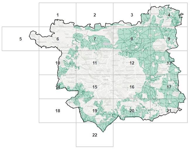
List of Solar Energy Opportunity Area maps
- Solar Energy Opportunity Area 3 - 1
- Solar Energy Opportunity Area 3 - 2
- Solar Energy Opportunity Area 3 - 3
- Solar Energy Opportunity Area 3 - 4
- Solar Energy Opportunity Area 3 - 5
- Solar Energy Opportunity Area 3 - 6
- Solar Energy Opportunity Area 3 - 7
- Solar Energy Opportunity Area 3 - 8
- Solar Energy Opportunity Area 3 - 9
- Solar Energy Opportunity Area 3 - 10
- Solar Energy Opportunity Area 3 - 11
- Solar Energy Opportunity Area 3 - 12
- Solar Energy Opportunity Area 3 - 13
- Solar Energy Opportunity Area 3 - 14
- Solar Energy Opportunity Area 3 - 15
- Solar Energy Opportunity Area 3 - 16
- Solar Energy Opportunity Area 3 - 17
- Solar Energy Opportunity Area 3 - 18
- Solar Energy Opportunity Area 3 - 19
- Solar Energy Opportunity Area 3 - 20
- Solar Energy Opportunity Area 3 - 21
- Solar Energy Opportunity Area 3 - 22
Policy EN3 - Wind Energy Opportunity Area 3
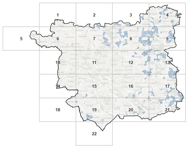
List of Wind Energy Opportunity Area maps
- Wind Energy Opportunity Area 3 - 1
- Wind Energy Opportunity Area 3 - 2
- Wind Energy Opportunity Area 3 - 3
- Wind Energy Opportunity Area 3 - 4
- Wind Energy Opportunity Area 3 - 5
- Wind Energy Opportunity Area 3 - 6
- Wind Energy Opportunity Area 3 - 7
- Wind Energy Opportunity Area 3 - 8
- Wind Energy Opportunity Area 3 - 9
- Wind Energy Opportunity Area 3 - 10
- Wind Energy Opportunity Area 3 - 11
- Wind Energy Opportunity Area 3 - 12
- Wind Energy Opportunity Area 3 - 13
- Wind Energy Opportunity Area 3 - 14
- Wind Energy Opportunity Area 3 - 15
- Wind Energy Opportunity Area 3 - 16
- Wind Energy Opportunity Area 3 - 17
- Wind Energy Opportunity Area 3 - 18
- Wind Energy Opportunity Area 3 - 19
- Wind Energy Opportunity Area 3 - 20
- Wind Energy Opportunity Area 3 - 21
- Wind Energy Opportunity Area 3 - 22
Policy G2C - Long Established Woodland
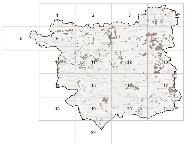
List of Long Established Woodland Area maps
- Long Established Woodland area map 1
- Long Established Woodland area map 2
- Long Established Woodland area map 3
- Long Established Woodland area map 4
- Long Established Woodland area map 5
- Long Established Woodland area map 6
- Long Established Woodland area map 7
- Long Established Woodland area map 8
- Long Established Woodland area map 9
- Long Established Woodland area map 10
- Long Established Woodland area map 11
- Long Established Woodland area map 12
- Long Established Woodland area map 13
- Long Established Woodland area map 14
- Long Established Woodland area map 15
- Long Established Woodland area map 16
- Long Established Woodland area map 17
- Long Established Woodland area map 18
- Long Established Woodland area map 19
- Long Established Woodland area map 20
- Long Established Woodland area map 21
- Long Established Woodland area map 22
Policy G8B - Leeds Habitat Network
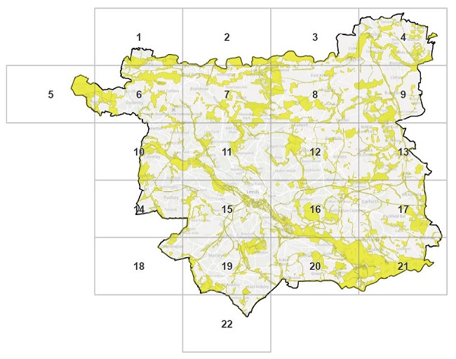
List of Leeds Habitat Network Area maps
- Leeds Habitat Network Area map 1
- Leeds Habitat Network Area map 2
- Leeds Habitat Network Area map 3
- Leeds Habitat Network Area map 4
- Leeds Habitat Network Area map 5
- Leeds Habitat Network Area map 6
- Leeds Habitat Network Area map 7
- Leeds Habitat Network Area map 8
- Leeds Habitat Network Area map 9
- Leeds Habitat Network Area map 10
- Leeds Habitat Network Area map 11
- Leeds Habitat Network Area map 12
- Leeds Habitat Network Area map 13
- Leeds Habitat Network Area map 14
- Leeds Habitat Network Area map 15
- Leeds Habitat Network Area map 16
- Leeds Habitat Network Area map 17
- Leeds Habitat Network Area map 18
- Leeds Habitat Network Area map 19
- Leeds Habitat Network Area map 20
- Leeds Habitat Network Area map 21
- Leeds Habitat Network Area map 22
Policy SP13 - Strategic Green & Blue Infrastructure Network
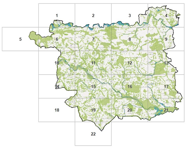
List of Strategic Green & Blue Infrastructure Network Area maps
- Strategic Green & Blue Infrastructure Network Area map 1
- Strategic Green & Blue Infrastructure Network Area map 2
- Strategic Green & Blue Infrastructure Network Area map 3
- Strategic Green & Blue Infrastructure Network Area map 4
- Strategic Green & Blue Infrastructure Network Area map 5
- Strategic Green & Blue Infrastructure Network Area map 6
- Strategic Green & Blue Infrastructure Network Area map 7
- Strategic Green & Blue Infrastructure Network Area map 8
- Strategic Green & Blue Infrastructure Network Area map 9
- Strategic Green & Blue Infrastructure Network Area map 10
- Strategic Green & Blue Infrastructure Network Area map 11
- Strategic Green & Blue Infrastructure Network Area map 12
- Strategic Green & Blue Infrastructure Network Area map 13
- Strategic Green & Blue Infrastructure Network Area map 14
- Strategic Green & Blue Infrastructure Network Area map 15
- Strategic Green & Blue Infrastructure Network Area map 16
- Strategic Green & Blue Infrastructure Network Area map 17
- Strategic Green & Blue Infrastructure Network Area map 18
- Strategic Green & Blue Infrastructure Network Area map 19
- Strategic Green & Blue Infrastructure Network Area map 20
- Strategic Green & Blue Infrastructure Network Area map 21
- Strategic Green & Blue Infrastructure Network Area map 22