-
Plan on a page
-
Introduction to the topic
-
Avoiding development in flood risk areas
-
Functional floodplain
-
Surface water flooding and sustainable drainage
-
Resilience
-
Permitted development rights and porous paving
Plan on a page
What the topic is about
As part of our aspiration to make Leeds zero carbon by 2030 we want to ensure that are communities are resilient to the impact of climate change. Flood Risk is one of the most direct impacts of climate change that Leeds faces. It’s important that up to date evidence, best practice and guidance are used to avoid, reduce and mitigate that risk.
Our vision
Leeds will ensure that new developments are located and designed to avoid, reduce and mitigate flood risk, increase biodiversity and reduce the carbon footprint of risk reduction schemes through natural flood solutions.
Where we are now
Our current local plan has many effective policies for flood risk and through flood alleviation schemes the council is working with partners and investing in infrastructure to help protect communities. But with the impacts of climate change worsening, it's important that we consider options for improving policies on flood risk.
Where we want to get to
We want to:
- ensure that all new developments are located and designated to avoid, reduce and mitigate flood risk
- reduce the speed of surface water run-off through increased use of sustainable and natural drainage systems
- ensure our policies reflect up to date evidence, guidance and best practice to help manage flood risk
Proposed policy areas
The areas of policy affected include:
- sustainable drainage systems
- enhanced resilience
- porous materials
- functional floodplain
Introduction to the topic
This topic paper sets out to raise awareness and stimulate discussion about how flooding is considered in planning decisions, what policies the council currently has to control development in areas at risk of flooding and what the recent Flood Alleviation Scheme means for specific parts of the city.
It clarifies that the council is in the process of updating its facts and figures about flood risk, which will help tell us how to manage land at risk. It also looks at how policies might be improved in the face of a changing climate and how flood risk from rivers and from rain can be better managed in new developments, including through what’s known as Sustainable Drainage Systems.
As part of a changing climate MET Office statistics show that winters in the UK have got 12% wetter over the last 60 years and they predict that rainfall is likely to rise by a further 20% by 2070 with an increase in rainfall intensity leading to 20% more flash flooding.
Local rainfall data shows that since July 2019 Leeds has generally been experiencing higher rainfall than the East and North East England average. Flood risk from rivers and flash floods is clearly a key part of the climate emergency agenda and we propose looking at whether our existing policies are strong enough to protect people and development from flooding and also to make sure that more development does not increase the risk.
The National Planning Policy Framework requires planning authorities to avoid locating development in flood risk areas, however it acknowledges that this is not always possible. In Leeds, which has grown historically along the Rivers Aire and Wharfe, it is important to consider other factors alongside flood risk, specifically the development needs of the City Centre and other town centres and the need to focus investment and regenerate parts of the City. This helps direct investment into places that need it and also to reduce pressure for release of Green Belt land. The planning system therefore has to balance competing conflicts in enabling investment whilst having regard to the effects of climate change.
National guidance also says that where development is necessary, planning authorities should be sure that it will be safe, without increasing flood risk elsewhere. In Leeds the Council has rigorous processes in place to ensure that development avoids flood risk where ever possible and that development is only approved when there is adequate mitigation in place. Some of our flood risk information comes from the Environment Agency but the Council also has a more detailed strategy for managing flood risk in the form of the Strategic Flood Risk Assessment. This defines the levels of flood risk throughout the whole district and gives detailed advice on how to manage it.
With the climate emergency it is important to consider whether the existing approach is still the best one and whether any development should be allowed in high risk flood areas or whether they can be defended or better designed and laid out. The predicted increases in rainfall could create problems for Leeds and potentially could lead to more people suffering the devastating impacts of flooding. The Boxing Day floods of 2015 resulted in the highest river levels ever recorded on both the River Wharfe and the River Aire notably more than a metre higher than the ‘Great Flood of Leeds’ 1866.
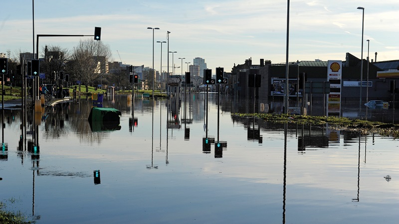
Boxing Day 2015 flooding at Kirkstall
What is flood risk
Flood risk in the UK is divided into different zones according to the probability of flooding. These flood zones are set by the Environment Agency and do not take account of any defences and they don’t include the possible impacts of climate change. The map in Appendix 1 gives an indication of the extent of each of these flood zones in the Leeds District, however this information will be updated shortly in the Council’s Strategic Flood Risk Assessment Update. The flood zones are as follows:
Flooding probability
| Zone 1 - Low Probability |
Land having a less than 1 in 1,000 annual probability of river flooding. |
| Zone 2 - Medium Probability |
Land having between a 1 in 100 and 1 in 1,000 annual probability of river flooding; |
| Zone 3a - High Probability |
Land having a 1 in 100 or greater annual probability of river flooding; |
| Zone 3b - The Functional Floodplain |
Land where water has to flow or be stored in times of flood. Usually with a 1 in 20 probability of river flooding |
Flooding in Leeds
The frequency of flooding events in Leeds has increased in recent years. Winter months have seen excessive rainfall over an extended period of time causing the rivers to exceed their capacity. Summer months have seen an increase in prolonged dry periods where the ground becomes baked and impenetrable followed by short intense downpours which run off quickly leading to surface water flooding.
The table below shows the number of incidents reported to the Council where internal flooding of property took place or there was an imminent threat of internal flooding. This is perhaps the most destructive type of flooding but flooding that affects roads and other forms of transport can also be devastating to people’s lives. The distribution of these incidents across the district can be seen on the map in Appendix 2.
number of incidents reported to the Council where internal flooding of property took place or there was an imminent threat of internal flooding
| Year |
Number of flood incidents reported (internal flooding or imminent threat of internal flooding)
|
| 2000 |
1 |
| 2002 |
2 |
| 2005 |
16 |
| 2006 |
8 |
| 2007 |
264 |
| 2008 |
27 |
| 2009 |
19 |
| 2010 |
13 |
| 2011 |
4 |
| 2012 |
82 |
| 2013 |
44 |
| 2014 |
452 |
| 2015 |
1266 |
| 2016 |
81 |
| 2017 |
129 |
| 2018 |
35 |
| 2019 |
177 |
| 2020 |
249 |
| 2021 |
15 |
There has been an increase in incidents over the last ten years. The large number in 2015 was due to Storm Eva and the storms that took place throughout December which meant that the rivers and water table were already high when Storm Eva took place. Storm Eva led to a 1 in 1,000 annual probability flood risk event on Boxing Day 2015. The number of properties across Leeds that were flooded or affected by the flooding from Storm Eva is shown in the table below:
properties across Leeds that were flooded or affected by flooding from Storm Eva
| |
Flooded |
Affected |
Total |
| Residential |
2300 |
411 |
2711 |
| ‐ Houses |
247 |
144 |
391 |
| ‐ Flats |
2053 |
267 |
2320 |
| Commercial |
541 |
137 |
678 |
| Other (churches, allotments, sports clubs) |
4 |
3 |
7 |
| Total |
2845 |
551 |
3396 |
Dealing with flooding
Some flooding can be dealt with through defending land. Leeds is constructing a flood alleviation scheme for the River Aire from Woodlesford up to Newlay Bridge. The first section is already constructed and operational, known as FAS 1.
The section from the Railway Station to the Knostrop weirs has a standard of protection of 1 in 100 annual probability of river flooding including a climate change allowance to 2039, whilst the section at Woodlesford has a 1 in 200 level of protection.
The second section (FAS 2) includes measures that will have the effect of upgrading the FAS 1 to a 1 in 200 standard of protection and includes a climate change allowance up to 2039. FAS 2 is also looking to identify ‘sacrificial’ land that is designed to flood which will further help us to make space for flood water.
The council are also implementing flood alleviation schemes on the River Wharfe at Otley, on the Wyke Beck and Wortley Beck. Neither national nor local funding exists to provide defences for all the urban areas at risk across the district.
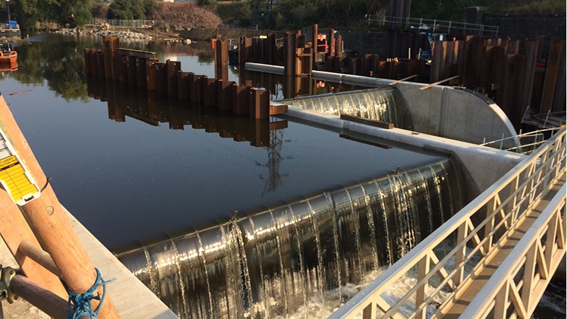
FAS 1: Knostrop Weir footbridge
New development is required to provide mitigation to reduce the frequency of flooding for example ensuring buildings are built to flood resilient standards and that sustainable drainage systems are incorporated where ever possible.
Leeds SFRA
Leeds Strategic Flood Risk Assessment (SFRA) was completed in 2007 and provides a comprehensive overview of the river and drainage systems across the district and associated flood risks. Since the SFRA was completed there have been significant changes, such as the FAS schemes that means it needs to be updated.
The updated version will be used to inform the policies in the Local Plan Update and should be available by early Summer this year. The updated SFRA will provide further technical advice on dealing with the flood risk issues listed below.
Until it is available we have sought to scope what the issues are without providing a detailed range of policy options at this stage.
Avoiding development in flood risk areas
Background
To minimise new development in areas of flood risk and in line with current government guidance we use the ‘sequential test’ to avoid development in flood risk areas as far as possible when allocating sites in the Local Plan and for planning applications for sites that are not allocated in the development plan.
The sequential test ensures that areas at little or no risk of flooding from any source are developed in preference to areas at higher risk. The aim is to keep development out of medium and high flood risk areas (flood zones 2 and 3) and other areas affected by other sources of flooding where possible.
Only where there are no reasonably available sites in flood zones 1 or 2 should the suitability of sites in Flood Zone 3a be considered, taking into account the flood risk vulnerability of the proposed land use.
If the site is proposed for a ‘more vulnerable’ use such as residential and is in a high flood risk zone (zone 3a), it may also have to pass an exceptions test, which shows that the development would provide wider sustainability benefits to the community that outweigh the flood risk and the development will be safe for its lifetime taking account of the vulnerability of its users, without increasing flood risk elsewhere, and, where possible, will reduce flood risk overall.
Current policy position
This approach forms the basis of flood risk policy in our current policies in the Natural Resources and Waste Local Plan (NRWLP). Policies are currently split across different Development Plan Documents with the overarching policy approach in Core Strategy EN5 and a more detailed suite of policies in the Water section of the NRWLP.
There is detailed guidance on sustainable drainage in SPG22 Sustainable Drainage. The water consumption policy is in Policy EN2 (ii) of the Core Strategy but there are also policies on water quality and water efficiency in the NRWLP.
Policy Water 4 was adopted in 2013 and has proved to be sufficiently robust as the basis for rejecting applications for inappropriate development in flood risk areas and only giving permission when all the relevant tests have been passed. However, because significant parts of the urban area include land in flood zones 2 and 3 (as shown on Map 1), some development takes place in flood risk areas.
Where applications in the urban area have passed the “exceptions test” by demonstrating wider sustainability benefits that outweigh the risk (for example, the need for regeneration, efficient use of brownfield land or to ensure our centres remain viable), approvals for planning permission are granted when there is adequate mitigation in place.
This includes ensuring buildings are built to flood resilient standards and that sustainable drainage systems are incorporated where ever possible.
Developers are also encouraged to lay out development so that open uses are located in the most risky parts of the site and the built development avoids those areas.
For sites with flood risk issues or any site which is over 1 hectare in size a Flood Risk Assessment (FRA) is required to be submitted with the planning application. The FRA is assessed by colleagues in the council’s Flood Risk Management team who advise whether the development will be safe.
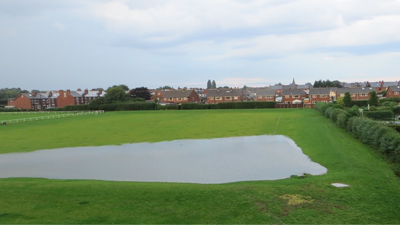
Barley Hill recreation ground flood water storage, an earth embankment reducing flood risk to 20 homes and properties. The flood risk management team worked closely with parks and countryside to ensure the works would not impact on the nearby football pitches. Additional fencing was also installed to maintain privacy to nearby homes.
Rationale for an enhanced policy framework
The Local Plan update provides an opportunity to bring all the flood risk policies together and review their effectiveness in the light of climate change.
Possible policy options
As part of the Local Plan update we want to consider whether policies could be improved to reduce the risk of flooding, and increase our resilience to flooding events.
There is an important balance to be struck between flood risk and other sustainability benefits, such as the need for regeneration, the efficient use of brownfield land and access to services. If policy tests are made tighter to further reduce the number of permissions for ‘more vulnerable’ development in flood risk areas this could result in people living further away from services and facilities that they need. This would then result in longer journeys and add to emission of greenhouse gases and other pollutant gases.
Consultation questions
1. Do you agree that our policy approach to development in flood risk areas should be within the scope of the Local Plan Update?
2. Have we got the balance right between locating homes close to the services and facilities that people need whilst avoiding high flood risk areas?
Functional floodplain
Background
The functional floodplain is the land where water has to flow or be stored in times of flood with a 1 in 20 annual probability of flooding. The extent of the functional floodplain is defined by the Strategic Flood Risk Assessment, which was prepared in 2007, and will shortly be updated. Most of the functional floodplain is open land and undeveloped.
Current policy position
The NPPF tells us we should manage flood risk by ‘safeguarding land from development that is required, or likely to be required, for current or future flood management’ (Para. 157 b) ).
Our current policy in the NRWLP is to safeguard land for flood storage (zone 3b) as shown in the SFRA. In those areas only water compatible uses and essential infrastructure is permitted.
Leeds is fortunate that much of the River Aire, as it flows through the urban area, will have the benefit of the Leeds Flood Alleviation Scheme and therefore significant parts of the urban area that would have otherwise flooded with a 1 in 20 year probability will be protected. The SFRA will look at reclassifying those areas so that they are not defined as having a flood storage function.
For those urban areas that have a 1 in 20 probability of flood risk but don’t have the benefit of a flood alleviation scheme, the redevelopment potential will continue to be limited due to the high flood risk probability. The SFRA will explore the extent of these areas and the impact of climate change.
The Local Plan update may consider the policy options for limiting development in those locations. This is only likely to affect those areas that have a very high level of flood risk and are not protected by a flood alleviation scheme.
Consultation question
3. Do you think that the Local Plan update should consider limitations on urban expansion in unprotected areas with a very high probability (1 in 20) of flooding?
Surface water flooding and sustainable drainage
Background
Sustainable drainage systems (SuDS) are designed to control surface water run off close to where it falls and mimic natural drainage as closely as possible. One of their uses is to reduce the causes and impacts of surface water flooding (sometimes referred to as flash flooding).
SuDS include a number of different practices or mechanisms designed to drain or soak up surface water in a more sustainable approach to the conventional practice of draining water run-off through a pipe into a sewer.
Practical examples include soakaways (draining water through permeable surfaces into the ground) and ponds (draining water into a surface water body). This water network is sometimes referred to as ‘blue infrastructure’.
SuDS capture rainfall, allowing as much as possible to evaporate or soak into the ground close to where it fell, then moving the rest to the nearest watercourse to be released at the same rate and volumes as prior to development. They improve water quality by reducing pollutants, such as metals and hydrocarbons from roads and car parks. Water entering a local watercourse is therefore cleaner and does not harm wildlife habitats.
They can provide a valuable amenity asset for local residents and create new habitats for wildlife. Any problems with the system are quicker and easier to identify than with a conventional underground pipe system and are generally cheaper and more straightforward to rectify. SuDS can also provide passive cooling which helps to mitigate the effect of temperature rise due to climate change.
Current Policy Position
The NPPF says that major developments should incorporate sustainable drainage systems unless there is clear evidence that this would be inappropriate (para 164 c)). This is the approach taken in NRWLP Policy Water 7 and echoed in Section 12 of the Sustainable Construction SPD which seek SuDS ‘wherever possible’. The NPPG gives further guidance on what “inappropriate” means:
The decision on whether a sustainable drainage system would be inappropriate in relation to a particular development proposal is a matter of judgement for the local planning authority. In making this judgement the local planning authority will seek advice from the relevant flood risk management bodies, principally the lead local flood authority, including on what sort of sustainable drainage system they would consider to be reasonably practicable.
The judgement of what is reasonably practicable should be by reference to the technical standards published by the Department for Environment, Food and Rural Affairs and take into account design and construction costs.
The NPPG goes on to set out that expecting compliance with the technical standards is “unlikely to be reasonably practicable if more expensive than complying with building regulations”. Similarly, a particular discharge route would not normally be reasonably practicable when an alternative would cost less to design and construct. This means that, at present, we cannot ask for sustainable drainage if the developer can show that a traditional system will be cheaper.
Current policy in the Natural Resources and Waste Local Plan (NRWLP) provides protection for water quality when development takes place close to sensitive water bodies such as lakes and rivers (NRWLP Policy Water 2).
Rationale for an enhanced policy framework
Given the many benefits of using SuDS against traditional systems, we believe the Local Plan Update should consider how the existing policy could be strengthened to make the use of SuDS a firmer requirement for new development, particularly given the benefits in addressing climate change resilience, biodiversity, health and wellbeing objectives and ambitions to improve the blue infrastructure.
Possible policy options
In order to strengthen the requirement to deliver SuDS we’re considering a number of potential policy approaches. These are not exhaustive and we would welcome any alternative ideas you may have.
One potential option we are considering is the mapping of infiltration rates to identify the areas that are most suitable for SuDS and this would support delivery of SuDS in those locations. Policy should also ensure that the proposed minimum standards of operation are appropriate and that there are clear arrangements in place for ongoing maintenance.
Another way to help manage surface water flooding is to identify the ‘source’ locations where heavy rainfall can lead to flooding downstream. Additional measures to reduce the speed of surface water run off at the source location, such as tree planting, can avoid the need for mitigation downstream. We are working with the University of Leeds to identify source locations and it may be appropriate for the Local Plan Update to provide a policy to ask for additional measures in those areas.
Consultation questions
4. Do you agree that surface water flooding and use of SuDS should be within the scope of the Local Plan Update?
5. Do you agree with our suggested approach to increasing the use of sustainable drainage systems in new development?
6. Do you think identifying and implementing additional measures at source locations would be an appropriate approach to managing surface water run off?
Resilience
Background
Flooding has a negative impact on the lives of everyone affected by it. Given the forecasted increases in rainfall we want to consider what we can do to make sure that new development is resilient.
There has been a rise in purpose built accommodation for people who are especially vulnerable, such as elderly and disabled. These people may be less able to cope with the impacts of flooding and the effects can be devastating for them.
Current policy position
The NPPF tells us to ensure that development is appropriately flood resistant and resilient and safe access and escape routes are included where appropriate, as part of an agreed emergency plan (para. 163).
We do this by requiring a flood risk assessment (FRA) to be submitted to accompany the application which informs the developer of mitigation measures to make sure the development will be safe for its lifetime and without making flood risk worse elsewhere for all affected people.
The FRA also has to take account of climate change projections for the future intensity of rainfall. National policy categorizes all residential development as ‘more vulnerable’ and not appropriate in high flood risk areas unless it has passed the sequential test (described above) but this does not recognise that some groups of people are even more vulnerable than others.
Possible policy options
Guidance is available on building flood resilient development, such as the ADEPT guidance ‘How to consider emergency plans for flooding as part of the planning process’ but there may be an opportunity to provide a clearer policy steer in the Local Plan. This could include a consideration of policy regarding safe access and escape routes and whether there should be any limitations on accommodation for more vulnerable groups in high flood risk areas.
Consultation questions
7. Should the Local Plan set new standards for flood resilient housing?
8. Should the Local Plan consider where accommodation for more vulnerable people is located?
Permitted development rights and porous paving
Background
The paving over of front gardens can result in increased flood risk caused by surface water runoff which is unable to drain naturally if impermeable materials are used. Additionally, the loss of vegetation can contribute to increased air pollution in urban areas and can affect the character and appearance of traditional streetscapes. The intensification of built development through the use of permitted development rights (eg to build extensions and garages) and the impact of climate change further compounds the problem.
Current policy position
As stated above, the council has existing policies related to sustainable drainage systems. However, they do not apply where planning permission is not required. Permitted development rights are set by the Government and set out types of development that do not require planning consent.
Some permitted development rights allow the building of extensions, garages and other structures that reduce the extent of the area available for natural drainage and holding water.
Other permitted development rights allow for the provision of a new or replacement hard surface (such as a driveway) within the curtilage of the grounds of different buildings, such as houses, offices and industrial buildings. These permitted development rights are limited to ensure that permeable materials are used.
Possible policy options
We’re keen to explore what approaches we could take to ensure that where landscaping and gardens provide a valuable function in helping manage flood risk, they are not subsequently lost through permitted development rights that allow the householder to build extensions, garages or other structures that reduce the extent of the area available for absorption.
One of the options may be to provide further guidance to householders on using porous materials when they are planning to convert front gardens to parking space.
Consultation questions
9. Should the Local Plan Update consider what approaches could be taken to limit permitted development rights for new developments to ensure open areas that are needed for flood risk management are retained?
10. Whilst not subject of a grant of planning permission should the Council consider how to control paving over front gardens and loss of soft and natural landscaping in existing development, for example through enhanced guidance for householders?