The name Red Hall will continue to be used for this section of the development, recognising that it is already well-established within the community, and has the listed Red Hall House dating back to the 17th century as its focal point.
- About the East Leeds Extension
- ELE developments
-
Red Hall
-
Whinmoor Fields (Northern Quadrant)
- Morwick Green (Middle Quadrant)
- Pendas Beck (Southern Quadrant)
- Other East Leeds developments
About the East Leeds Extension
The ELE will deliver up to 5,000 new homes and supporting infrastructure on allocated land within the Site Allocations Plan, and so will play a major role in delivering the housing needed to meet the Local Plan requirements for 52,000 new homes across the city by 2033.
Its design is based on promoting safe and healthy places which contribute to better health and well-being, through creating high-quality new homes set within attractive and connected green spaces. The ELE will have strong links to the existing local communities, and we want ELE's residents and neighbours to feel a sense of pride and ownership over how it has developed.
The council has worked with a wide range of landowners, developers, and other stakeholders to ensure that the development will have outstanding public spaces, green infrastructure linkages, sustainable transport options, community infrastructure and culture, a range of types and sizes of housing including 15% affordable housing, and high quality design.
In order to allow development of the ELE overall, there was a requirement for a major new dual carriageway scheme in a green corridor setting to create new capacity and links for vehicles, cyclists, pedestrians and equestrians, plus reduce pressure on the existing Outer Ring Road.
This is one of the largest infrastructure schemes in the city for decades. The Council has therefore led on delivery of the East Leeds Orbital Route (ELOR) around the eastern edge of the housing allocation which will link the existing Outer Ring Road at Red Hall to J46 of the M1 through Thorpe Park. ELOR is due to open fully in autumn 2022.
While the ELOR will be the edge of the built up area, beyond there will also be a new country park, public rights of way linkages, and improved cycleways for new and existing residents alike. Sustainable urban drainage systems will be a key part of the greenspace network, to mitigate against flooding and provide a dual benefit for wildlife and amenity.
The ELE development will create construction and supply chain jobs, and will be required to develop employment and training schemes for employment opportunities and training for local people and firms.
We have produced the East Leeds Extension Supplementary Planning Document to support the overall delivery of the ELE, and it forms part of the planning guidance for the scheme.
ELE developments
The allocated housing land is owned by a range of landowners and developers including Leeds City Council. As well as leading the planning and delivery of ELOR, we coordinate between land holding and developer interests as new housing proposals are brought forward, as well as the necessary community infrastructure to support this development.
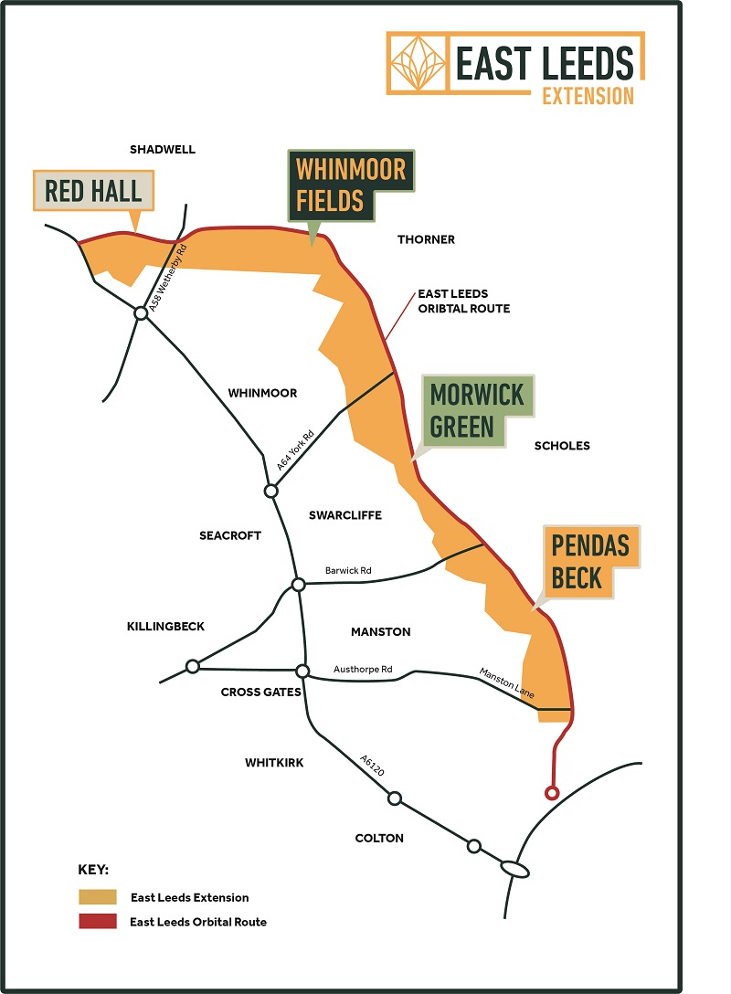
The whole of the ELE is split into different areas for the purposes of planning applications to bring forwards the new housing and infrastructure.
Red Hall
The Red Hall site covers 29 hectares between the Outer Ring Road and A58 Wetherby Road at the very northern end of the ELE.
It is the former site of our horticultural nursery and playing fields, which relocated to Whinmoor Grange as part of The Arium development. It is currently being used as the compound to deliver the East Leeds Orbital Route (ELOR). Additional parts of the site comprise of open amenity space, woodland, and some small listed buildings which are outbuildings of the main house.
The Listed Red Hall House and stables sits within 1 hectare at the centre of this wider council owned Red Hall site. It was owned by the Rugby Football League and used as their headquarters for 25 years, but was sold in 2021 with the new buyer intending to turn it to a private day hospital.
Housebuilder Redrow Homes submitted a planning application on the council's land in 2021 for 360 dwellings, conversion of the listed outbuildings, and public greenspace and walking and cycling trails. If planning permission is approved, we will then sell our land to Redrow Homes to allow them to start construction in 2023.
The principle of redevelopment of the site is long-standing. The 2006 Unitary Development Plan Review allocated the land for both housing and a key business park as part of the ELE.
The principle of wholly residential use across the whole of the Red Hall site was then put forward through the Site Allocations (Issues and Options) consultation undertaken in 2013, and was ultimately approved in 2019 as a housing allocation in the Site Allocations Plan (SAP).
A small part of the site to the north of the ELOR was Green Belt before its housing allocation in the SAP. The SAP High Court relief judgement therefore applies to this housing allocation, which was re-examined by the Planning Inspectorate in Autumn 2021 alongside a number of others across the city. The SAP webpage provides more information.
A planning brief for Red Hall was agreed in 2017 to guide the sale and future development of the site.
Further details can also be found on the webpage of Redrow's planning agent.
The planning application is available to view online by visiting Leeds Public Access and using the reference: 21/04468/FU.
Whinmoor Fields (Northern Quadrant)
An outline planning application by a consortium of different developers and landowners has recently been approved, and planning permission granted. The developers are now working up detailed planning applications for the housing and associated greenspace and infrastructure to come forwards in phases across the site.
We have been working with the applicant and local community groups to address issues such as the layout of highways, the impact on local traffic, location of land for a new primary school, securing the provision of 15% affordable housing, and provision of green space and a major country park on land between the A58 and A64.
The council's Plans Panel approved this application in principle in 2015 and following changes to the scheme to account for changes in planning policy, Plans Panel received further details in 2016, and in January 2020.
The planning application is available to view online by visiting Leeds Public Access and using the reference: 12/02571/OT.
The name Whinmoor Fields takes inspiration from the neighbouring area of Whinmoor, the local landscape, and its ancient heritage as home to two potential battlefield sites of Winwaed (655 AD) and Seacroft Moor (1643).
Morwick Green (Middle Quadrant)
An outline application for up to 875 dwellings and associated greenspace and infrastructure was recommended for approval at our Plans Panel on 26 November 2021, subject to finalising the legal agreement.
It is closely linked to the application for Pendas Beck which will provide the joint community infrastructure for both schemes.
Morwick Green is promoted by developers Persimmon and Taylor Wimpey.
The planning application is available to view online by visiting Leeds Public Access and using the reference: 20/04464/OT.
Further details can also be viewed on the webpage of the planning agent: Middle Quadrant – Johnson Mowat.
The name Morwick Green keeps the connection with the local area and heritage as the site skirts Morwick Hall and Morwick Farm.
Pendas Beck (Southern Quadrant)
An outline application for this site was submitted in November 2021. It will include 925 dwellings and associated greenspace, plus community infrastructure within a local centre to include a primary school and community use playing pitch, a healthcare and wellbeing facility, and small-scale retail.
Pendas Beck is promoted by housebuilders Taylor Wimpey and Redrow Homes, alongside Leeds City Council in our role as a landowner.
The planning application is available to view online by visiting Leeds Public Access and using the reference: 21/08379/OT.
A requirement of development of the local centre on council land is also for the reprovision of existing playing pitches, which will be relocated to our Arium site at Whinmoor Grange.
The name Pendas Beck relates to the neighbouring Pendas Fields community, and the sources of water surrounding the area which are Cock Beck, Carr Beck and Chippy's Quarry.
Other East Leeds developments
The next stage of the nearby Thorpe Park Leeds development beyond the southern end of the ELE will provide extra office, shopping and leisure uses, alongside 300 new homes and greenspace, and a new train station and park and ride on the Trans-Pennine route between Leeds and York.
A requirement of development of the local centre on council playing field land off Leeds Road in the ELE Pendas Beck development, the John Smeaton Playing Fields, requires the reprovision of the existing playing pitches.
Alongside retention of one pitch within the new primary school to be built on the same site, the intention is for the remaining two pitches to be relocated to the council's site at Whinmoor Grange (adjacent to The Arium).
The planning application for two grass football pitches, parking, access, and landscaping was submitted in January 2022.
The planning application is available to view online by visiting Leeds Public Access and using the reference: 22/00107/FU.
These pitches will be of a higher quality than those existing, with dedicated pitch parking, good cycling and pedestrian links, and users will be able to access The Arium for refreshments.
Supplementary Planning Document (SPD)
The East Leeds Extension SPD forms part of the planning guidance for the whole of the ELE. Find the document on our SPD page.