It would be inconsistent with the council’s duty to promote the licensing objectives to grant new and variation applications for any premises licence which seeks off sales of alcohol at any time.
Licensing Act 2003
We published a revised Statement of Licensing Policy, in accordance with Section 5 of the Licensing Act in January 2025.
This policy must be reviewed every 5 years but may be reviewed sooner if necessary.
Under the Licensing Act 2003 we can publish an assessment of cumulative impact of licensed premises in our area. Such an assessment was undertaken in 2025, and the Cumulative Impact Assessment 2026 to 28 was approved by Licensing Committee in January 2026. Applicants for licences in the following areas should contact Entertainment Licensing to discuss their proposals in relation to cumulative impact. Click on the arrow to expand the text and to read more about each area.
Armley
This summary is intended to be a much shorter summary of the map, policy and evidence for each area to aid the applicant and their representatives, people making representations and responsible authorities. The summaries are not intended to replace the full evidence document, which is available from Entertainment Licensing, by email.
Area overview
The area covered by this cumulative impact assessment and policy is shown in the map.
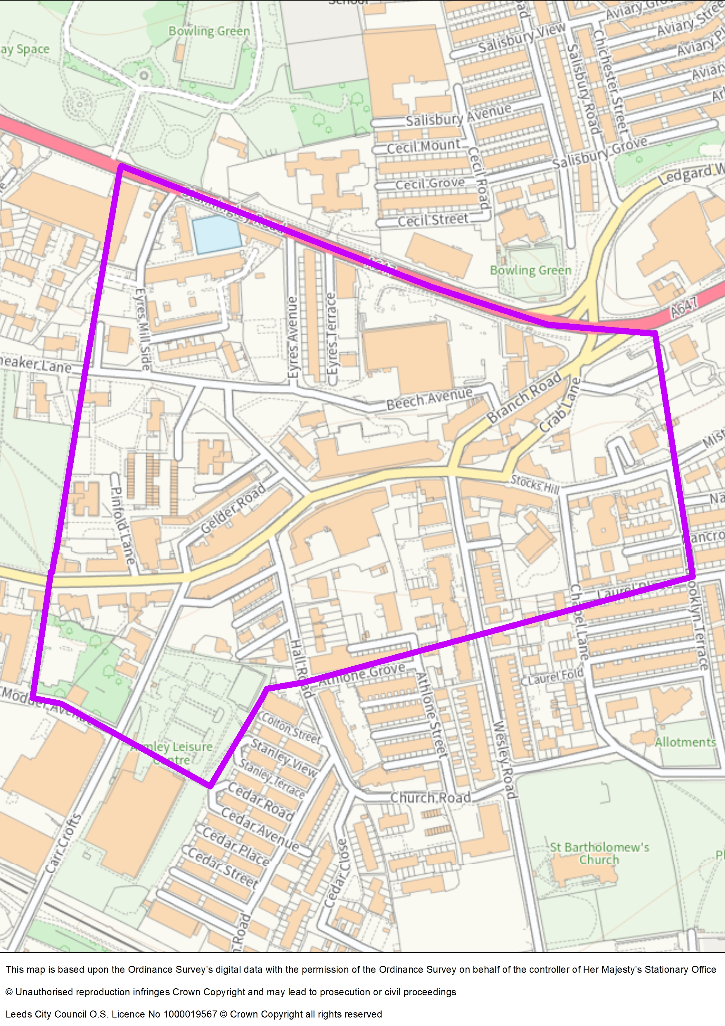
This area relates to the main shopping areas of Armley, known as Armley Town Street and Branch Road.
Policy
Paragraphs 7.26 to 7.28 Of Leeds City Council’s Statement of Licensing Policy states:
7.26 The council has assessed anti-social behaviour and crime statistics for the area known as Armley and has determined that there is an area that is suffering from the cumulative impact of off-licensed premises and consequently this is leading to problems which are undermining the licensing objectives. Specifically, Town Street and Branch Road are the areas affected. Maps showing the exact geographical area included in this area can be found in the cumulative impact assessment.
7.27 In this area the nature of the problems is predominantly anti-social behaviour perpetrated by people purchasing alcohol on Town Street and Branch Road and then remaining in the area to drink it. More information on the evidence can be found in the cumulative impact assessment.
7.28 It would be inconsistent with the council’s duty to promote the licensing objectives to grant new and variation application for any premises licence which seeks off sales of alcohol at any time.
Area overview and context
The CIA covers the main shopping area (Armley Town Street and Branch Road), an area which has experienced persistent street drinking, visible groups of drinkers, and related antisocial behaviour, reported by residents and addressed via multi‑agency efforts including police injunctions.
In 2014 the council recognised this as an area that would benefit from Local Licensing Guidance due to poor health outcomes of people living in LS12. This gave potential businesses extra information about the problems in Armley and encouraged new businesses to think about the impact they are having in the area.
Residents have reported to the local councillors and MP their concerns about large groups of mostly male street drinkers gathering on Town Street. Residents find this intimidating and have reported feeling that this area is becoming a no-go zone. West Yorkshire Police, Leeds Antisocial Behaviour Team and the council are working with these groups to stop the antisocial behaviour and have issued injunctions to stop several people from coming back to Town Street.
This wasn’t considered to be effective enough due to the lack of engagement by licence holders, so in 2018 Armley was designated as a cumulative impact area.
Quantitative evidence – alcohol licensing data matrix (MSOA ranking and indicators)
The CIA sits within Armley and New Wortley MSOA (E02002400) which ranks 2nd out of 107 MSOAs in Leeds—placing it in the “very high” risk band. The Matrix shows very high or high scores across alcohol treatment need, alcohol‑specific emergency admissions, ambulance callouts, AUDIT scores, and multiple alcohol‑related crime and antisocial behaviour indicators.
The area ranks second highest in Leeds for number of off‑licences, evidencing a dense retail supply of alcohol.
Specific indicator ranks (extracts): alcohol‑related antisocial behaviour (9th – very high), drunk and disorderly (23rd – high), alcohol‑flagged crime (20th – high), and alcohol‑flagged violent crime (29th – medium)—all within a context of very high overall harm.
Quantitative evidence – WYP crime and nuisance statistics
777 crimes recorded in the Armley CIA over the 36‑month period (≈22 per month); high‑volume groups include assault, public order, and other violence. In the latest 12 months: 104 assaults, 42 public order, 45 other violence, plus 38 “theft other”, 10 robberies, 8 sexual offences. Crime clusters on Town Street, with peaks at lunchtime and afternoon.
Top street counts (12 months): Town Street (82 crimes), Stanningley Road (26), Theaker Lane (30), Wesley Road (15), Burnsall Gardens (15), Mistress Lane (15). Time‑of‑day analysis shows a broad spread, but with meaningful late‑evening/overnight activity on several streets.
Police‑recorded nuisance incidents: 137 over three years (≈4 per month), predominantly youth‑related or adult non‑alcohol nuisance; peaks afternoon; highest volumes at Carr Crofts and Burnsall Grange.
Local authority ASB service requests (LCC): 80 nuisance cases in three years, mostly noise, abuse/intimidation/harassment, and drug/alcohol‑related; plus 181 environmental nuisance records (fly‑tipping, litter, commercial waste).
Heat mapping indicates assaults and public order concentrating around Town Street, consistent with street drinking and shopfront clustering.
Standardised coding yields 79 alcohol‑identified crimes and 15 alcohol‑identified nuisance incidents in three years, most frequently assault and public order, with higher counts on Town Street, Theaker Lane, and Mistress Lane: volume peaks overnight.
Ward‑level maps confirm the CIA area as a high‑volume cluster within the broader Armley ward context.
Qualitative evidence and consultation themes
Respondents support retaining the CIA. Concerns include street drinking, ASB, crime, underreporting, and retailers selling alcohol alongside illicit goods. Police presence is appreciated; however, fear/demoralisation suppresses reporting.
“Residents find this intimidating and have reported feeling that this area is becoming a no-go zone.” - Armley residents via ward councillors
“West Yorkshire Police, LASBT and the council are working with two groups to stop the antisocial behaviour.” - Multi-agency update
Conclusion
The current policy in this area is that:
Over the last three years the issues being experienced in this area and reported through multi-agency meetings have not changed.
The MSOA still ranks second highest in the city, despite the amount of work engaged in by partners, residents and businesses to improve this area.
The review of the area and the consultation responses show that street drinking is still linked to antisocial behaviour and crime, there is underreporting of issues due to fear and demoralisation, retailers are selling alcohol alongside illicit goods, and there is support for the continuation of the CIA.
After reviewing the Alcohol Licensing Data Matrix and the crime statistical data provided by Safer Leeds, as well as the response to the consultation, the licensing authority is of the opinion that this cumulative impact area and scope should remain as it is currently. The licensing authority recognises the underreporting of crime is an issue and the community concerns. There will be continued enforcement and multi-agency interventions.
Any application received which seeks off sales of alcohol at any time can expect to receive representations from West Yorkshire Police and the Licensing Authority and applicants should consider potential cumulative impact issues when setting out the steps that will be taken to promote the licensing objectives. Applications will normally be refused unless the applicant can demonstrate that the operation of the premises will be unlikely to add to the cumulative impact.
Beeston
This summary is intended to be a much shorter summary of the map, policy and evidence for each area to aid the applicant and their representatives, people making representations and responsible authorities. The summaries are not intended to replace the full evidence document, which is available from Entertainment Licensing, by email.
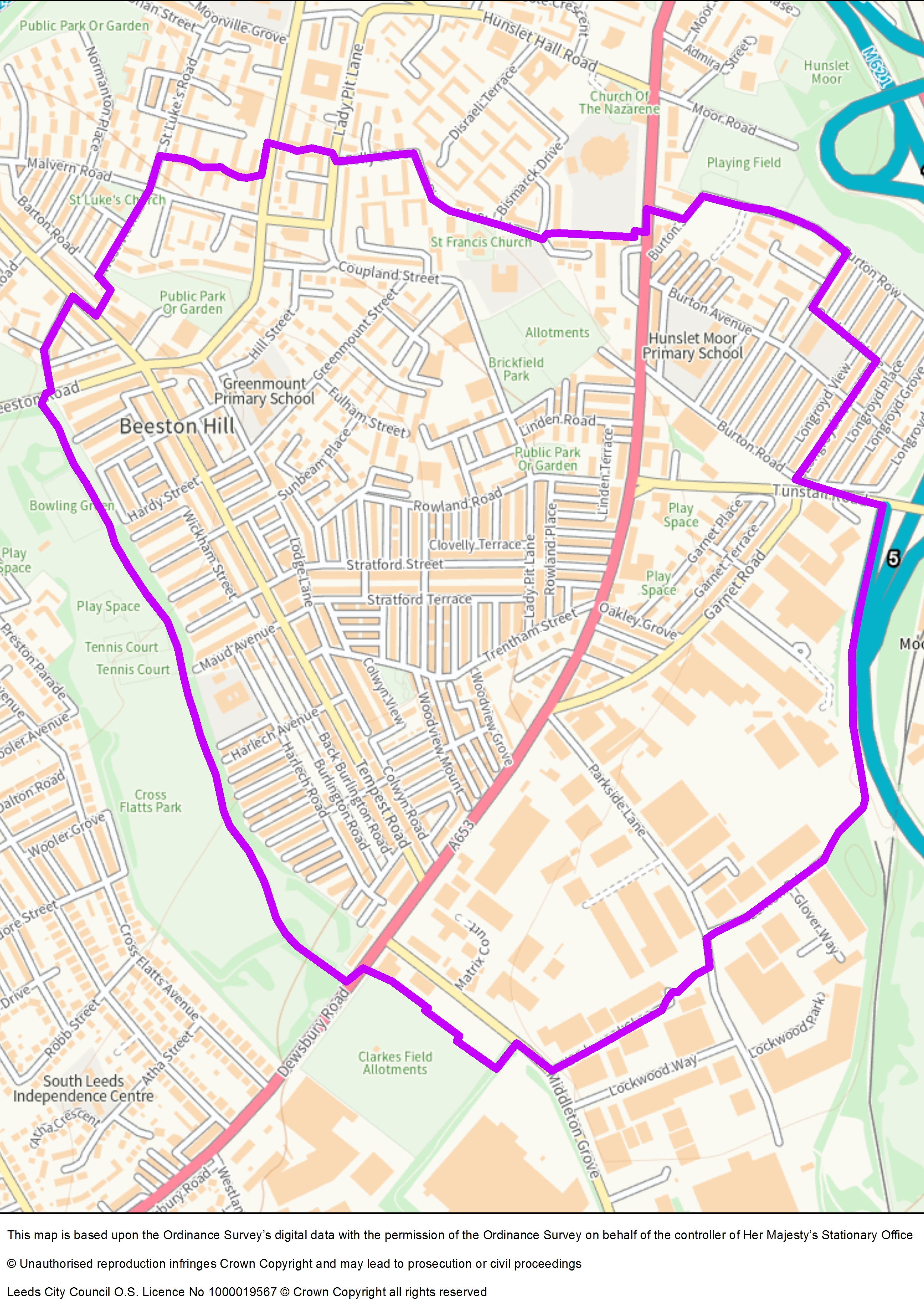
Area overview
The area covered by this cumulative impact assessment and policy is shown in the map.
Beeston is a dense urban neighbourhood with numerous small, independent convenience and takeaway premises (along Dewsbury Road/Tempest/Beeston Road), alongside larger retailers (Tesco, ALDI, Iceland). Recent years have seen rising licensing activity in deprived areas.
Multi‑agency problem‑solving (May 2023) addresses street drinking, drug use/dealing, begging, and sex work (especially around Beeston Hill and Holbeck Priority Neighbourhoods). Challenges include groups outside the Community Hub drinking/urinating, rough sleeping at large retailers, prolific shoplifting, and sale of single cans by some off‑licences.
Policy
Paragraphs 7.35 to 7.37 of the Leeds City Council Statement of Licensing Policy state:
7.35 The council has assessed crime statistics, alcohol risk data and licensing statistics for the area known as Beeston. Comments provided by partners, residents and businesses in the area show that this area is suffering the cumulative impact of off-licensed premises and late-night refreshment premises.
7.36 In this area the nature of the problems is alcohol related crime and nuisance, specifically anti-social behaviour of people who drink alcohol in the street, whether that be due to alcohol dependency or cultural social drinking. The area experiences litter from take away premises.
7.37 The policy in this area is that it would be inconsistent with the council’s duty to promote the licensing objectives to grant new and variation applications for any premises licence which seeks off sales or late night refreshment to operate in the area known as Dewsbury Road, but which includes Dewsbury Road, up to Cross Flatts Park, Tempest Road and Beeston Road.
Quantitative evidence – alcohol licensing data matrix (MSOA ranking and indicators)
The CIA spans two very high‑risk MSOAs: Beeston Hill and Hunslet Moor (rank 7/107), and Cross Flatts Park and Garnets (rank 6/107); both show very high scores for alcohol‑flagged crime/violent crime, drunk and disorderly, noise and litter complaints, deprivation, and vulnerability of children (high under‑16 population; looked‑after children; NEET).
Beeston East (south‑west) ranks 33/107 (medium) yet still exhibits very high off‑licence density and high drunk & disorderly, noise, and litter, plus indicators of vulnerable children.
Quantitative evidence – police crime and nuisance analysis (WYP; 1 Jun 2021–1 Jun 2024)
Zone One (Beeston Hill): Overall crime ↓16% over 3 years, with reductions in Drunk & Disorderly, Violence with Injury, and Public Order; however, Robbery and Theft from Person have risen. Peak offending windows are daytime 15:00–19:00. Streets with notable issues include Dewsbury Road (crime fluctuating; net ↓9% from 21/22 to 23/24) and Tempest Road (↑6% overall). Bismarck Street showed a 106% overall increase due to neighbour disputes/domestics.
Nuisance ASB (Zone One): Overall down 18%; Youth‑related down 35%, while Nuisance Motorcycle/Quadbike up 81%; Fireworks/Snowballing spiked then fell; Lodge Lane up 317% nuisance (motorbike noise).
Zones Two and Three (south of Cross Flatts): Crime down 21% overall with fluctuating street‑level patterns; Rape reported up 600%, though only one stranger case involving a pub meeting was noted; Robbery doubled compared to 21/22; Theft from Person decreased markedly. Dewsbury Road remains the top crime and ASB street because of its length and commercial intensity.
Qualitative evidence (agencies, schools, residents, councillors)
Agencies report unsafe environments near the Community Hub and schools, aggressive/intimidating behaviours inside and outside public facilities, large volumes of alcohol container litter, elderly residents frightened by early‑morning off‑sales, concerns about 24‑hour off‑licences drawing street drinkers and underreporting due to fear.
Schools and family services report daily clearance of broken bottles, needles, used condoms, exposure of children/parents to drunken/abusive behaviour, proximity of alcohol outlets to nurseries and community centres.
Ward councillors report strong evidence of deprivation‑linked alcohol harms, groups street drinking, begging at major retailers, declining liveability, and out‑migration intent. A CIA is viewed as key to controlling supply while other interventions proceed.
Conclusion
The policy in this area is that:
It would be inconsistent with the council’s duty to promote the licensing objectives to grant new and variation applications for any premises licence which seeks to sell alcohol for consumption off the premises, or late-night refreshment to operate in the area known as Dewsbury Road, but which includes Dewsbury Road up to Cross Flatts Park, Tempest Road and Beeston Road.
In more deprived areas, the reporting of crime is historically lower than in more affluent areas even though Safer Stronger Communities, West Yorkshire Police and resident organisations do encourage the reporting of crime. In areas such as Beeston Hill, it is useful to look at the crime statistics not as a specific number, but as representative of the issues in each of the streets, and the most prevalent types of crimes.
Taking into consideration all the evidence, including the qualitative evidence provided by partners agencies and residents, the main crimes this area is suffering from are public order offences, violence with injury and theft.
Dewsbury Road has, by far, the greatest crime. Nearly all the agencies report issues with people who drink in the street in groups. As outlets in this area sell alcohol early in the morning until late at night, a culture of street drinking has developed. The evidence from the Community Hub Manager reports aggressive and violent behaviours being displayed by people using their facilities, and the excessive drinking is happening outside their Hub, with people sitting and drinking all day.
The Crime Reduction Officer reports residents’ concerns about shops selling alcohol early in the day and the impact this has on people. The Cleaner Neighbourhoods Team collect large amounts of cans and glass bottles. The primary schools report that their pupils, staff and parents witness people being drunk and abusive and displaying highly inappropriate behaviours. The ward councillors link the increase in licensed premises with an increase in people who drink in the street, with that now being a common sight.
The areas where people report problems are around Dewsbury Road and Tempest Road.
With the evidence provided by residents and people working in the area, which is confirmed by the crime statistics and the Health Data Matrix data, the council would consider that the area shown within the purple boundary on the map as suffering from the cumulative impact of licensed premises in the area. This is having a negative impact on all four licensing objectives, but especially crime and disorder, public nuisance and the protection of children from harm.
This assessment is of evidence provided by Public Health through the Alcohol Licensing Data Matrix, West Yorkshire Police through updated crime statistics, as well as additional information provided by residents and people working in the area as well as comments received during the public consultation.
The area to the south of Cross Flatts Park, known as Beeston/Beeston Village/Parkside and Cross Flatts will be kept under review. Should the issues being experienced in Beeston Hill displace to this area, evidence will be gathered, and this area assessed for cumulative impact. In any case this area will be included in the three-yearly review of Beeston Hill. This assessment has also considered the area to the south of Cross Flatts Park. The evidence of problems in this area is not as strong, but the concern that there may be displacement of licences into this area should a cumulative impact area be put in place further north are understandable.
Any application received which seeks off sales of alcohol or late-night refreshment at any time can expect to receive representations from West Yorkshire Police and the Licensing Authority and applicants should consider potential cumulative impact issues when setting out the steps that will be taken to promote the licensing objectives. Applications will normally be refused unless the applicant can demonstrate that the operation of the premises will be unlikely to add to the cumulative impact.
City Centre
This summary is intended to be a much shorter summary of the map, policy and evidence for each area to aid the applicant and their representatives, people making representations and responsible authorities. The summaries are not intended to replace the full evidence document, which is available from Entertainment Licensing, by email.
Area overview
The area covered by this cumulative impact assessment and policy is shown in the map.
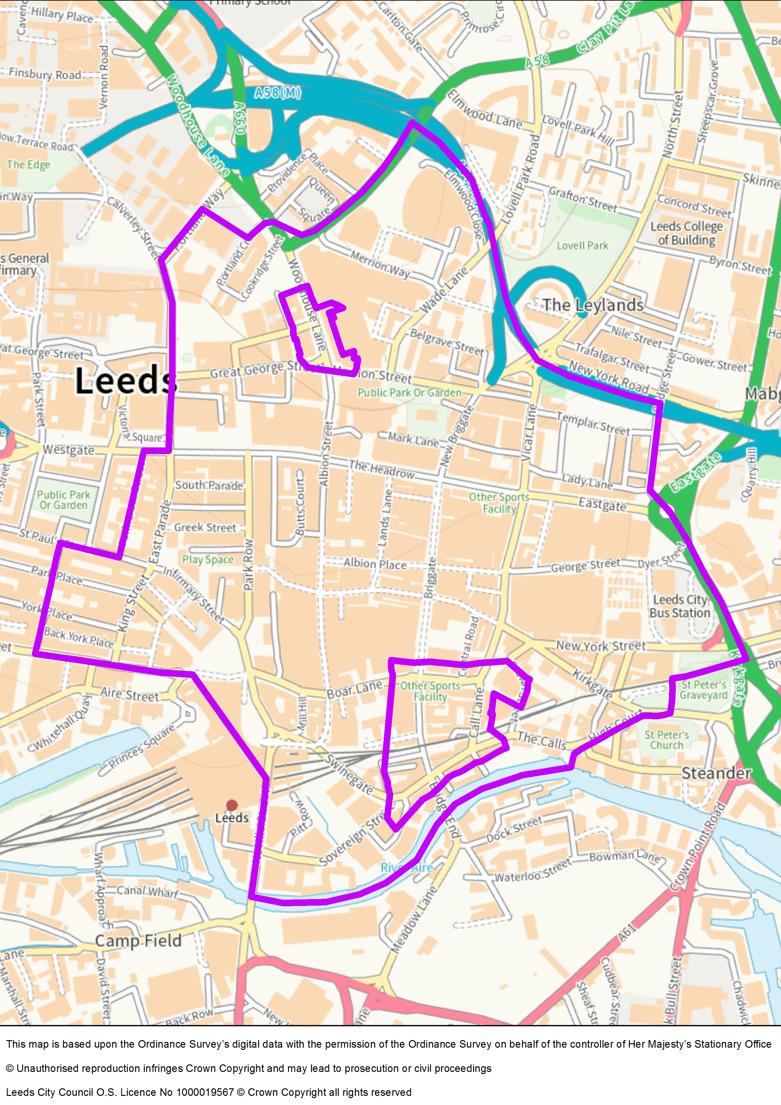
The city centre cumulative impact area relates to the city centre. It is placed within the Little London & Woodhouse and Hunslet and Riverside wards. The current scope of the cumulative impact area is shown in this map. The two areas in the north and south of the city are designated as 'red zones'. The scope is reviewed each year, using the crime statistics which show hot spot areas to ensure that it covers only the most severely affected areas.
Policy
Paragraphs 7.15 to 7.18 of Leeds City Council’s Statement of Licensing Policy state:
7.15 The council has assessed crime statistics for the area known at the city centre which is located between the A58M motorway and the river Aire and has determined that there is an area that is suffering from the cumulative impact of licensed premises and consequently this is leading to problems which are undermining the licensing objectives.
7.16 Specifically and in addition to this, there are two areas of special concern designated as red zones where the impact of the licensed premises is so severe that the council considers that any application for a new licence or the variation of an existing licence should be refused unless the applicant can show how their application would not lead to an increase in the impact of licensed premises in this area. Maps showing the exact geographical area included in this area, and specifically the red zones can be found in the cumulative impact assessment.
7.17 In this area the nature of the problems is alcohol related violent crime being perpetrated on people visiting and using this area during specific peak hours. More information on the evidence can be found in the cumulative impact assessment.
7.18 It would be inconsistent with the council’s duty to promote the licensing objectives to grant new and variation application for any premises licence (on sales, off sales and late night takeaways) that seek to operate during the peak hours described in the cumulative impact assessment for the city centre.
In the City Centre CIA, new or varied licences (on‑sales, off‑sales, late‑night refreshment) operating during the peak hours (typically 23:00–03:00) will normally be refused in the designated red zones unless the applicant shows the operation will not add to cumulative impact. Variations that effectively increase occupancy or capacity are treated akin to new applications in red zones. Elsewhere in the CIA, applicants must propose robust, tailored mitigations, with police/licensing authority engagement.
Quantitative evidence – alcohol licensing data matrix (MSOA ranking and indicators)
The City Centre MSOA (E02006875) ranks 1st of 107, the highest overall risk, with very high scores for on‑licence density, off‑licence density, licensing risk, alcohol‑identified crime, violent crime (alcohol‑flagged), drunk and disorderly, and noise/litter complaints. Health harm indicators among residents of the MSOA are also very high (for example, alcohol‑related ambulance callouts rank 1st).
Quantitative evidence – crime and nuisance (WYP/CSPI analysis, April 2022 to March 2025)
15,831 crimes recorded across the City Monitoring Zone and red zones (around 440 per month). In the latest year: 2,265 assaults, 702 public order, 359 other violence; plus 779 “theft other”, 245 robbery, 170 sexual offences. Briggate (718 crimes in the last 12 months) and Call Lane (446) are high‑volume streets with peaks on weekends and overnight.
Nuisance incidents: 1,578 over three years (around 44 per month), predominantly adult non‑alcohol, youth‑related, or alcohol‑related; high concentrations on Boar Lane, York Street, Albion Street, Briggate, New York Street, Dyer Street; time peaks afternoon and evening.
Drunk and disorderly: 344 offences in three years (around 10 per month), strongly concentrated during late‑night/overnight periods.
Alcohol‑identified crimes: 2,506 over three years (around 70 per month); nuisance 429 (Boar Lane notable). Peaks early morning and overnight, with spatial clusters around Briggate, Call Lane, and Boar Lane.
Operational implications and enforcement
Given saturation, responsible authorities do not generally negotiate conditions in red zones for peak‑hour trading; management controls like door staff alone are insufficient to address crowding-driven street impact. Elsewhere, applicants should adopt Box M guidance‑type measures and engage early with WYP/Licensing.
Conclusion
The current policy in this area is that
It would be inconsistent with the council’s duty to promote the licensing objectives to grant new and variation applications for any premises licence (on sales, off sales and late-night takeaways) that seek to operate during the peak hours described in the cumulative impact assessment for the city centre.
After reviewing the Alcohol Licensing Data Matrix and the crime statistical data provided by West Yorkshire Police, the Council is of the opinion that this cumulative impact area and scope should remain as it is still the most appropriate given the evidence. The red zones to remain in place and reviewed annually by analysing the crime statistics provided by Safer Leeds, or by another reporting mechanism should the Police be unable to provide these statistical reports in the future.
Peak hours
Analysis of crime and nuisance data for the city centre cumulative impact area, including the designated red zones, shows a clear concentration of incidents during the late-night economy period. Police data indicates that crime volume on streets such as Briggate and Call Lane rises sharply after 23:00, with the highest levels recorded between midnight and 03:00. Assault, public order offences, and alcohol-identified crimes peak during these hours, coinciding with the busiest trading period for bars and nightclubs. Nuisance incidents, including noise complaints and alcohol-related antisocial behaviour, also cluster in this timeframe. This pattern demonstrates that the cumulative impact of licensed premises is most pronounced during 23:00–03:00, justifying the restriction of new or varied licences operating in these hours to protect the licensing objectives.
Application in the red zones will normally be refused unless the applicant can demonstrate that the operation of the premises will be unlikely to add to the cumulative impact.
Any application (especially those that seek alcohol for consumption on or off the premises) received for the rest of the city centre should be of good quality, with proportionate measures offered taking into consideration this is a busy nighttime economy area with its associated issues.
Additional consideration will be given to those premises seeking the sale for alcohol for consumption off the premises (such as convenience stores, off licences) in areas where there is already antisocial behaviour such as New Market Street/Vicar Lane, near the bus station, New York Street, and near Penny Pocket Park.
Guidance on suitable measures is provided in the council’s guidance note, Box M Guidance, available from Entertainment Licensing.
Harehills and Burmantofts
This summary is intended to be a much shorter summary of the map, policy and evidence for each area to aid the applicant and their representatives, people making representations and responsible authorities. The summaries are not intended to replace the full evidence document, which is available from Entertainment Licensing, by email.
Area overview
The area covered by this cumulative impact assessment and policy is shown in the map.
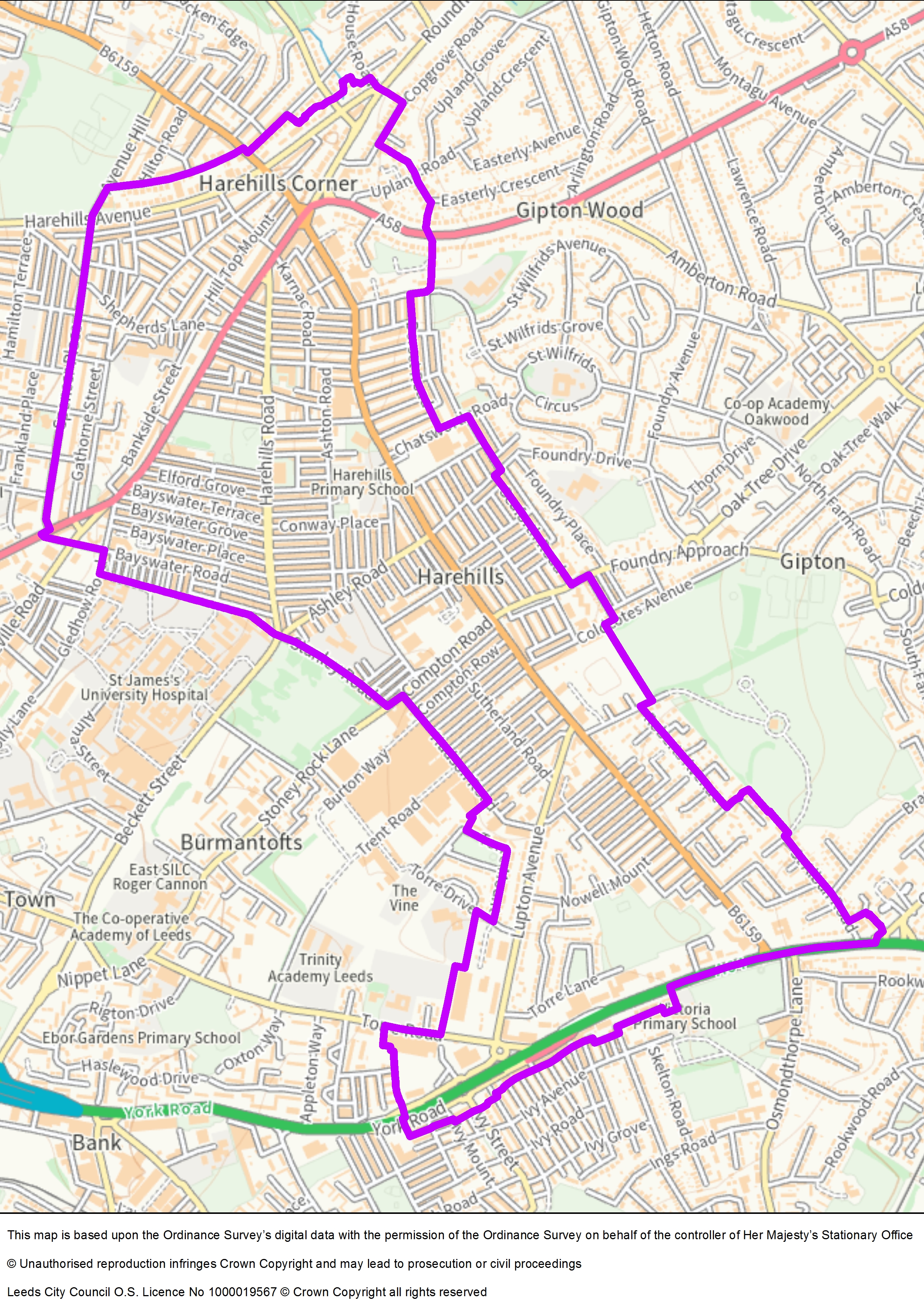
Harehills is an area to the east of Leeds city centre. It is an area that crosses two wards - Gipton and Harehills and Burmantofts and Richmond Hill. This area has many streets of terraced houses which offers cheaper housing. The area is cultural and ethnically diverse. It is situated in the country’s top 5% of areas of deprivation. Unemployment is high at 9%.
Policy
Paragraphs 7.29 to 7.31 of Leeds City Council’s Statement of Licensing Policy state:
7.29 The council has assessed crime statistics for the area known as Harehills and has determined that there is an area that is suffering from the cumulative impact of off-licensed premises and consequently this is leading to problems which are undermining the licensing objectives. Specifically, the area around Harehills Road and Harehills Lane is particularly suffering from the cumulative impact of too many off licences. Maps showing the exact geographical area included in this area can be found in the cumulative impact assessment.
7.30 In this area the nature of the problems is alcohol related violent crime and nuisance being suffered by people living in this mainly residential area. More information on the evidence can be found in the cumulative impact assessment.
7.31 It would be inconsistent with the council’s duty to promote the licensing objectives to grant new and variation application for any premises licence which seeks off sales and late-night refreshment to operate during the peak hours described in the cumulative impact assessment for Harehills.
Quantitative evidence – alcohol licensing data matrix (MSOA ranking and indicators)
Harehills South (rank 18/107 – high): very high under‑16 population, low educational attainment, looked‑after children, NEET; high off‑licence density; very high/high alcohol‑related crime indicators (drunk and disorderly, alcohol‑flagged violent crime, alcohol‑related ASB).
Harehills North (rank 29/107 – medium/high): very high drunk & disorderly (rank 6) and high alcohol‑related ASB (rank 13); high off‑licence density around Roundhay Road.
Burmantofts (rank 11/107 – high): very high for under‑16 population, looked‑after children, NEET, and low educational attainment; high off‑licence density; very high alcohol‑flagged violent crime and noise complaints.
Quantitative evidence – crime and nuisance (WYP/CSPI analysis, April 2022 to March 2025)
8,241 crimes in the CIA over three years (around 229 per month), dominated by assault, other violence, and public order; top streets include Harehills Lane (274 crimes in latest 12 months), Harehills Road, Roundhay Road, Compton Road, York Road, Milan Road. Peaks around lunchtime and afternoon.
Nuisance incidents (WYP): 1,085 over three years (around 30 per month), mainly youth‑related, adult non‑alcohol, neighbour‑related, and alcohol; time peaks afternoon/evening; concentrations on Harehills Lane, Harehills Road, Roundhay Road.
Local authority ASB requests (LCC): 1,135 nuisance cases (noise, abuse/intimidation/harassment, drug/alcohol issues); 1,615 environmental nuisance records (fly‑tip/fly‑tipping, litter complaint, commercial waste).
Drunk and disorderly: 55 offences in three years (around 2 per month), representing persistent low‑level intoxication harms.
Vulnerability and safeguarding
Across the three MSOAs, indicators show large concentrations of vulnerable children and families experiencing alcohol‑related harms, notably high ambulance callouts, hospital stays, and emergency admissions linked to alcohol. These burdens are disproportionate in Harehills/Burmantofts relative to many other Leeds MSOAs.
The council has recognised that there are many complex issues relating to alcohol in Harehills. The most obvious issue is around the groups of alcohol dependent drinkers who gather near to the off licences which serve them. The council have engaged the services of Touchstone who provide outreach services to this group, engaging with over 100 different individuals assisting them with options for treatment, but also operating as a de facto one stop shop, assisting with housing and benefits issues as well. Dependent street drinkers do not travel far from the off licences they buy their alcohol from. They will hang around in groups of up to 20 in side streets and alley ways. The local neighbourhood policing team will engage with the groups encouraging them to move on when they become disorderly. They may need to do this multiple times over their shift, making this group resource intensive.
This is not the only group of people in Harehills that have an impact on the community in Harehills. There is an issue with alcohol related disorder associated with large groups spread across Harehills who socialise, often late at night, with music playing. The council deals with numerous complaints relating to children who are left to play out in the street unsupervised at very young ages until very late at night. Leeds Antisocial Behaviour Team had a period of success in dealing with such groups last year by using Premises Closure legislation to affect a large-scale closure of streets, with over 90 individuals summonsed to court. This avenue has now been closed by amendments to the legislation prohibiting its use for streets.
The council tackle this issue through education with targeted interventions with families concentrating primarily on the child safeguarding aspect with the Police and the council's Environmental Protection Team dealing with alcohol related antisocial behaviour and noise.
Conclusion
The current policy in this area is that
It would be inconsistent with the council’s duty to promote the licensing objectives to grant new and variation applications for any premises licence which seeks off sales and late-night refreshment to operate during the peak hours described in the cumulative impact assessment for Harehills.
The council has assessed crime statistics for the area known as Harehills and has determined that there is an area that is suffering from the cumulative impact of off-licensed premises and consequently, this is leading to problems which are undermining the licensing objectives. Specifically, the area around Harehills Road and Harehills Lane is particularly suffering from the cumulative impact of too many off licences. In this area the nature of the problem is alcohol related violent crime and nuisance being suffered by people living in this mainly residential area.
The entire Harehills area is home to the most vulnerable children in Leeds. Children are not only vulnerable because of their own circumstances but can be disproportionately affected by alcohol related crime and disorder.
Over the last three years the issues being experienced in this area and reported through multi-agency meetings have not changed despite the huge amount of work being carried out by partners in relation to the Clear, Hold, Build initiative. Ward Members have reported that the revocation of 12 alcohol licences from off licences in the area has had a positive impact.
After reviewing the Alcohol Licensing Data Matrix and the crime statistical data provided by Safer Leeds, as well as the response to the consultation the Council is of the opinion that the area and scope of this cumulative impact area should remain the same to support the ongoing work in this area. Any application received can expect to receive representations from West Yorkshire Police and the Licensing Authority as a minimum, and applicants should consider potential cumulative impact issues when setting out the steps that will be taken to promote the licensing objectives.
There are no peak hours for this area.
Applications will normally be refused unless the applicant can demonstrate that the operation of the premises will be unlikely to add to the cumulative impact.
Headingley
This summary is intended to be a much shorter summary of the map, policy and evidence for each area to aid the applicant and their representatives, people making representations and responsible authorities. The summaries are not intended to replace the full evidence document, which is available from Entertainment Licensing, by email.
Area overview
The area covered by this cumulative impact assessment and policy is shown in the map.
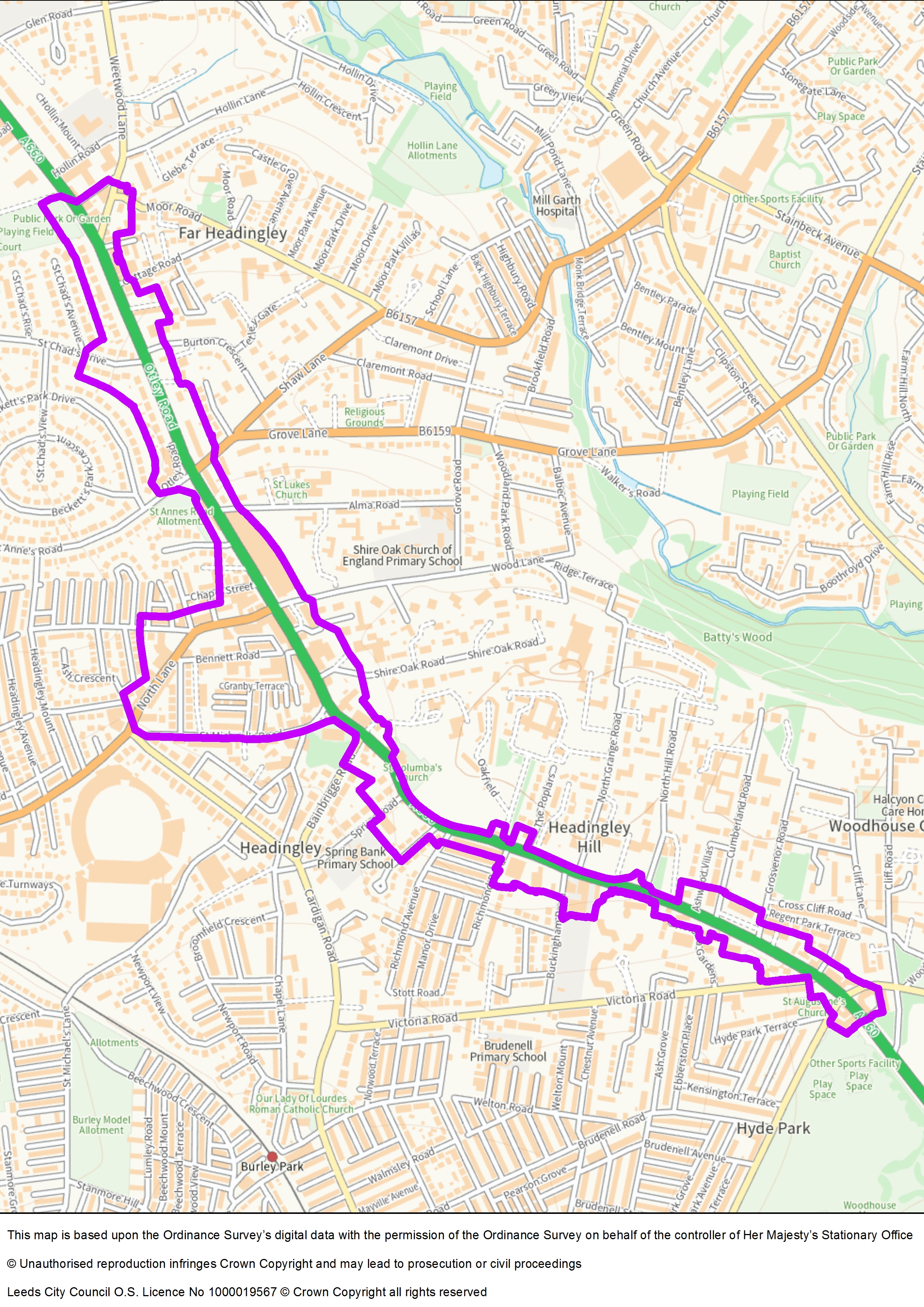
In the past the Headingley cumulative impact area has been part of a much larger cumulative impact area which incorporated the entire area impacted by the Otley Run and known as the Headingley and Hyde Park Cumulative Impact Policy. In 2018 it was decided to split this area into two to address the different concerns more suitably in each area.
In 2022 the area was expanded to include the start of the Otley Run. In 2025 the area was expanded again to include the Hyde Park end of Headingley Lane. Although this now rejoins the Headingley and Hyde Park CIAs, the concerns in each area are different. Headingley is mainly concerned with alcohol sales to those participating in the Otley Run and other late-night activity. The Hyde Park CIA is mainly concerned with the nuisance caused by student parties and the 24 hour off licences that feed this behaviour.
Policy
Paragraphs 7.19 to 7.22 of Leeds City Council’s Statement of Licensing Policy state:
7.19 The council has assessed crime statistics for the area known as Headingley and has determined that there is an area that is suffering from the cumulative impact of licensed premises and consequently this is leading to problems which are undermining the licensing objectives. Specifically, the area is located around North Lane and Otley Road. Maps showing the exact geographical area included in this area can be found in the cumulative impact assessment.
7.20 Additionally, Headingley suffers from nuisance and crime related to the large number of visitors participating in the ‘Otley Run’. This is a largely unorganised pub crawl which starts in Weetwood early afternoon and progresses along Otley Road towards the city centre. This has been an activity undertaken primarily by students however in the last few years it has become more popular with groups of people travelling from outside of Leeds. This influx of people during the weekends and the associated crime, nuisance, and antisocial behaviour, is having a detrimental effect on residents who no longer feel able to use the shops, restaurants, and bars on the Otley Road in Headingley due to large groups of drunk people in fancy dress gathering along the route.
7.21 In this area the nature of the problems is alcohol related violent crime and nuisance being perpetrated on people visiting this area during specific peak hours. More information on the evidence can be found in the cumulative impact assessment.
7.22 It would be inconsistent with the council’s duty to promote the licensing objectives to grant new and variation application for any premises licence (on sales, off sales and late night takeaways) that seek to operate during the peak hours, described in the cumulative impact assessment for Headingley or to any application that may encourage participation in the Otley Run.
Quantitative evidence – alcohol licensing data matrix (MSOA ranking and indicators)
The quantitative evidence for Headingley highlights its classification as a medium-risk area overall, but with several indicators showing very high concern. The alcohol licensing data matrix places Headingley in 35th position out of 107 Leeds MSOAs, yet it ranks 6th for on-licensed premises density and 7th for alcohol-related antisocial behaviour, reflecting the concentration of pubs and bars in the area. The licensing risk score is also high (10th), indicating enforcement officers’ limited confidence in management practices. While drunk and disorderly crime ranks 23rd, this figure likely underrepresents the true scale of issues due to underreporting and police resource constraints. Notably, Headingley ranks 4th for AUDIT scores, suggesting residents report high levels of potentially harmful alcohol consumption to GPs.
Quantitative evidence – crime and nuisance (WYP/CSPI analysis, April 2022 to March 2025)
Crime and nuisance data reinforce these concerns. Analysis shows two distinct peaks in alcohol-related activity: 1pm to 6pm, coinciding with the start of the Otley Run, and 10pm to 3am, during the late-night economy. These periods see significant spikes in assaults, public order offences, and nuisance incidents, particularly on Otley Road and North Lane. Heat maps confirm that crime clusters around these streets, with incidents during peak hours far exceeding daytime levels. This pattern demonstrates that the cumulative impact of licensed premises is most pronounced during these windows, posing a substantial risk to public safety and amenity.
Health-related indicators further underscore the area’s vulnerability. Headingley scores very high for AUDIT measures and alcohol treatment need, suggesting a strong correlation between local drinking culture and health harms. Combined with high ambulance callouts and emergency admissions in adjacent MSOAs, the data paints a picture of sustained alcohol-related harm. These findings align with qualitative evidence from residents and agencies, who report persistent issues linked to the Otley Run, including noise, litter, public urination, and harassment.
Evidence narrative – consultation and lived experience
Respondents describe unsafe streets, staff harassment, blocked pavements, and negative business impacts; they recommend strengthened enforcement under the Licensing Act 2003, Highways Act 1980, and Environmental Protection Act 1990 to curb on‑street drinking behaviours and associated nuisance.
Community responses (including ARARA and other residents’ groups) document gaps in CIA coverage that allow large pub chains to exploit the Otley Run route, driving noise, litter, public urination, harassment, and congestion. Specific licensing cases (for example, the Golden Beam seeking licence changes to admit Otley Run participants) were cited as evidence of route‑driven saturation.
Conclusion
The current policy in this area is that:
It would be inconsistent with the council’s duty to promote the licensing objectives to grant new and variation application for any premises licence (on sales, off sales and late night takeaways) that seek to operate during the peak hours, described in the cumulative impact assessment for Headingley, or to any application that may encourage participation in the Otley Run.
Analysis of crime and nuisance data for Headingley shows two distinct peaks in alcohol-related activity. The first occurs during the afternoon and early evening (1pm to 6pm), coinciding with the Otley Run, when large groups move between venues, causing congestion, noise, and public nuisance. The second peak occurs overnight (11pm to 3am), when crime data indicates the highest levels of assaults, public order offences, and nuisance calls. Time-split graphs confirm that these periods represent the greatest risk to the licensing objectives, with incidents during these windows significantly exceeding other times of day.
The council has assessed crime statistics for the Headingley area and determined that the cumulative impact of licensed premises continues to undermine the licensing objectives. The evidence shows persistent issues linked to the Otley Run, including public order offences, assaults, and nuisance behaviour concentrated along Otley Road and North Lane. Crime peaks during evenings and overnight, and ambulance callouts remain high, indicating significant alcohol-related harm.
Consultation responses confirm strong community concern. Residents, ward councillors, and partner agencies report that the Otley Run attracts large crowds, causing congestion, intimidation, and environmental blight such as litter, broken glass, and public urination. Families avoid the area during weekends due to safety concerns, and businesses report disruption and loss of trade. Schools and community hubs highlight risks to children from exposure to disorderly and sexualised behaviour.
Despite multi-agency interventions and enforcement of Public Spaces Protection Orders, the issues remain unchanged. The density of licensed premises and the nature of the Otley Run continue to exacerbate crime, nuisance, and public safety risks. Respondents strongly oppose any relaxation of restrictions and call for stricter conditions, including queue management, limits on outdoor seating, and controls on Otley Run promotion.
The Council recognises that premises density in the extended section (from Bainbrigge Road to Hyde Park Corner) is lower than in central Headingley. The case for extension rests on route-based cumulative impact rather than simple premises counts. To ensure proportionality:
- a rebuttable presumption applies only where granting a licence or variation would add to cumulative impact
- applications that are food-led, low-risk, and demonstrably neutral may overcome the presumption if robust mitigations are offered
- applicants should address Otley Run-specific risks (queue/dispersal management, pavement stewardship, restrictions on promotions, capacity controls, external area management)
Holbeck
This summary is intended to be a much shorter summary of the map, policy and evidence for each area to aid the applicant and their representatives, people making representations and responsible authorities. The summaries are not intended to replace the full evidence document, which is available from Entertainment Licensing, by email.
Area overview
The area covered by this cumulative impact assessment and policy is shown in the map.
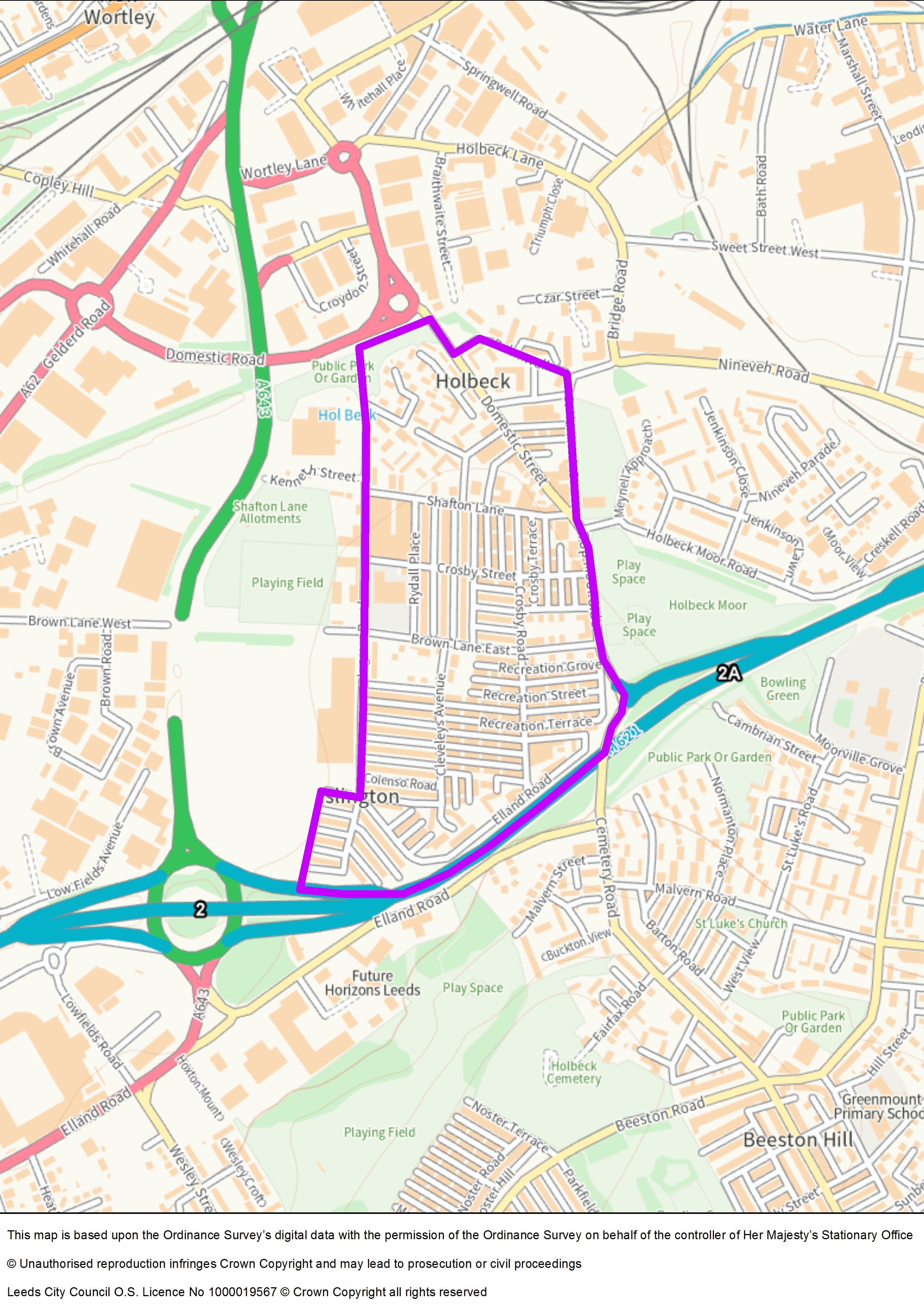
Holbeck is an inner-city area of Leeds, West Yorkshire, England. It begins on the southern edge of Leeds city centre and mainly lies in the LS11 postcode district. The district currently falls within the Beeston and Holbeck ward of Leeds City Council.
Policy
Paragraphs 7.32 to 7.34 of Leeds City Council’s Statement of Licensing Policy state:
7.32 The council has assessed crime statistics, alcohol risk data and licensing statistics for the area known as Holbeck. The evidence of a slow increase of off licensed premises in the cumulative impact area, the output from the alcohol licensing data matrix which shows very high levels of alcohol related crime, disorder and a population of vulnerable adults and children, as well as the conclusions from the Police report, the council considers this to be an area suffering from the cumulative impact of off licensed premises.
7.33 The density of convenience stores, newsagents and off licences already selling alcohol in the area is disproportionate to the other retail premises in the area.
7.34 It would be inconsistent with the council’s duty to promote the licensing objectives to grant new and variation applications for any premises licence which seeks off sales of alcohol at any time.
Quantitative evidence – alcohol licensing data matrix (MSOA ranking and indicators)
The quantitative evidence for Holbeck demonstrates that this area faces significant alcohol-related challenges, both in terms of crime and health harms. The alcohol licensing data matrix ranks Holbeck’s MSOA 8th out of 107 in Leeds, placing it in the “very high” risk category. Crime indicators are particularly concerning drunk and disorderly offences rank 2nd highest citywide, while alcohol-flagged crime and alcohol-flagged violent crime both rank 5th. Noise complaints are also very high (6th), reflecting persistent public nuisance issues. These figures indicate that the cumulative impact of licensed premises is strongly linked to disorder and environmental problems in this densely populated residential area.
Health-related data reinforces this picture of vulnerability. Holbeck scores very high for alcohol-related ambulance callouts, alcohol treatment, and alcohol-specific emergency admissions, as well as high for alcohol-related hospital stays and stroke prevalence. These indicators suggest a concentration of individuals at risk of serious alcohol-related health harms. Combined with its high deprivation ranking (12th), the area exhibits a profile where alcohol misuse disproportionately affects already vulnerable populations, compounding social and health inequalities.
The retail environment exacerbates these issues. Holbeck contains a dense cluster of licensed premises, particularly convenience stores and takeaways concentrated along Domestic Street and Top Moor Side. This saturation of off-licensed outlets facilitates easy access to alcohol, contributing to street drinking and associated antisocial behaviour. Despite enforcement efforts, these problems remain entrenched, with crime and nuisance data showing persistent patterns of harm over the review period.
Evidence narrative – multi‑factor harms and multi‑agency response
The council’s multi‑agency problem‑solving partnership (from May 2023) targets long‑term crime/ASB challenges: street drinking, drug use/dealing, begging, and sex work, with noted environmental impacts (needles, litter, human waste) and community fear. This includes coordinated work between Communities Team, Leeds Antisocial Behaviour Team, and partners.
Evidence shows vulnerable individuals with complex needs; outreach support runs in parallel to enforcement, underlining the public safety and health dimensions intertwined with licensing availability.
Conclusion
The current policy in this area is that:
It would be inconsistent with the council’s duty to promote the licensing objectives to grant new and variation applications for any premises licence which seeks off sales of alcohol at any time.
The review of crime and nuisance data, combined with feedback from enforcement partners, demonstrates that Holbeck continues to experience alcohol-related harm. Street drinking and associated antisocial behaviour remain prevalent, contributing to community safety concerns and environmental issues. These problems disproportionately affect vulnerable residents and undermine efforts to improve the area.
After considering the evidence, the council is of the opinion that the Holbeck cumulative impact area and its scope should remain unchanged. Applications seeking off sales of alcohol can expect representations from West Yorkshire Police and the Licensing Authority.
Applications will normally be refused unless the applicant can demonstrate that the operation of the premises will be unlikely to add to the cumulative impact.
Hyde Park
This summary is intended to be a much shorter summary of the map, policy and evidence for each area to aid the applicant and their representatives, people making representations and responsible authorities. The summaries are not intended to replace the full evidence document, which is available from Entertainment Licensing, by email.
Area overview
The area covered by this cumulative impact assessment and policy is shown in the map.

Hyde Park is a predominantly residential area with a large proportion of houses converted into multiple occupancy dwellings, reflecting its proximity to the Headingley campus and its popularity for student accommodation. Over recent years, the area has experienced persistent issues with noise, litter, and disorder linked to student parties and the easy availability of alcohol from 24-hour off-licences. These factors have contributed to ongoing community concerns about public safety and quality of life.
Policy
Paragraphs 7.23 to 7.25 of Leeds City Council’s Statement of Licensing Policy state:
7.23 The council has assessed crime statistics for the area known as Hyde Park and has determined that there is an area that is suffering from the cumulative impact of licensed premises and consequently this is leading to problems which are undermining the licensing objectives. Specifically, the area is located between Hyde Park Road, Victoria Road, Cardigan Road, and Burley Lodge Road. Maps showing the exact geographical area included in this area can be found in the cumulative impact assessment.
7.24 In this area the nature of the problems is alcohol related violent crime and nuisance being suffered by people living in this mainly residential area. More information on the evidence can be found in the cumulative impact assessment.
7.25 It would be inconsistent with the council’s duty to promote the licensing objectives to grant new and variation application for any premises licence which seeks off sales and/or late-night refreshment to operate during the peak hours described in the cumulative impact assessment for Hyde Park.
Quantitative evidence – alcohol licensing data matrix (MSOA ranking and indicators)
The quantitative evidence for Hyde Park shows that this area faces significant challenges linked to alcohol-related harm and nuisance. Hyde Park sits within MSOA E02006861 (Hyde Park Corner & Woodhouse Cliffe), which ranks 16th out of 107 MSOAs in Leeds, placing it in the high-risk category. The area scores very high for AUDIT scores (1st), indicating that residents report some of the highest levels of potentially harmful alcohol consumption to GPs. It also ranks very high for alcohol treatment need (4th) and ambulance callouts (8th), suggesting a strong correlation between local drinking patterns and health harms. These indicators highlight the vulnerability of the population and the strain on health services.
Licensing-related data reinforces these concerns. Hyde Park ranks high for on-licensed premises density (15th) and high for off-licensed premises density (23rd), reflecting the concentration of pubs, bars, and convenience stores in the area. The licensing risk score is medium (37th), but the combination of high premises density and very high health harm indicators suggests that the cumulative impact of licensed premises is substantial. Nuisance-related datasets also show worrying trends: Hyde Park ranks very high for alcohol-related antisocial behaviour (3rd) and very high for noise complaints (3rd), confirming persistent issues with public nuisance and disorder.
Crime data adds further weight to the case for intervention. While violent crime flagged as alcohol-related is ranked medium (26th), overall alcohol-flagged crime ranks high (17th), and drunk and disorderly offences rank medium (41st). These figures, combined with the nuisance rankings, suggest that Hyde Park experiences a mix of health-related harm and environmental disruption rather than extreme violent crime. The evidence points to a pattern of late-night noise, litter, and antisocial behaviour concentrated around student accommodation and popular drinking routes, particularly during weekends and university term times.
Quantitative evidence – crime statistics
Police time‑of‑day analysis shows a clear late‑night concentration: alcohol‑related crime and nuisance peak between 23:00 and 03:00, with the highest volumes typically recorded on Friday and Saturday nights. This window is highlighted as the period of greatest risk to the licensing objectives in Hyde Park.
Within those peak hours, assault and public order offences dominate the recorded crime picture, alongside increased nuisance calls attributable to alcohol. The police analysis specifically identifies these categories as the main drivers of overnight activity in the area.
Street‑level mapping and narrative from the police data indicate that problems are concentrated around Hyde Park Corner and adjacent residential streets (near Woodhouse Moor), reflecting both through‑movement between venues and local late‑night refreshment/off‑sales activity that feeds street drinking and disorder.
Complementing the WYP statistics, the Alcohol Licensing Data Matrix for the Hyde Park MSOA reports very high alcohol‑related antisocial behaviour, with alcohol‑flagged crime and noise complaints assessed at medium—together reinforcing the police picture of persistent overnight disorder and nuisance rather than extreme levels of recorded violent crime outside the peak window.
Conclusion
The current policy in this area is that:
It would be inconsistent with the council’s duty to promote the licensing objectives to grant new and variation applications for any premises licence which seeks off-sales and/or late-night refreshment to operate during the peak hours described in the cumulative impact assessment for Hyde Park.
Peak hours
Analysis of crime and nuisance data for Hyde Park shows that alcohol-related incidents are concentrated during the late-night economy period, with the highest volumes occurring between 11pm and 3am. Police data highlights that assaults, public order offences, and nuisance calls peak overnight, particularly on Fridays and Saturdays, coinciding with the Otley Run and late-night refreshment activity. Time-split graphs and street-level data confirm that incidents during these hours significantly exceed daytime levels, demonstrating that this window represents the greatest risk to the licensing objectives.
The council has reviewed crime and nuisance data, alongside the consultation response, and determined that the cumulative impact of licensed premises continues to undermine the licensing objectives. Persistent issues include alcohol-related crime, noise nuisance, and environmental harm concentrated around Hyde Park Corner and adjacent residential streets. These problems disproportionately affect vulnerable residents and students, and they contribute to a decline in community amenity.
After considering the evidence, the council is of the opinion that the Hyde Park cumulative impact area and its scope should remain unchanged. Applications seeking off-sales or late-night refreshment during peak hours can expect representations from West Yorkshire Police and the Licensing Authority.
Applications will normally be refused unless the applicant can demonstrate that the operation of the premises will be unlikely to add to the cumulative impact.
A CIA helps manage the cumulative impact of licensed premises on crime, disorder, public nuisance, and public safety. It does not ban new licences or stop people from applying for them but creates a presumption against granting them unless applicants can show they will not add to the impact. Each application will still be considered on its merits. However, applicants must provide strong evidence that their premises will not contribute to cumulative impact. The CIA applies to new licence applications and variations, not to existing licences.
The Council has produced Cumulative Impact Assessment which includes crime statistical data, alcohol harms data, as well as qualitative data from agencies and residents in the cumulative impact areas. It also provides the responses to both consultations and the council response. Under the legislation, the cumulative impact assessment must be 'published'. However, due to its substantial length (232 pages), it is not practical to publish the full document on the internet. To ensure compliance with the statutory requirement, both digital and paper copies are available on request from entertainment.licensing@leeds.gov.uk. The Council has also produce 4 page summaries for each area which are also available.
Gambling Act 2005
We published a revised Statement of Licensing Policy in accordance with Section 349 of the Gambling Act 2005 on 1 January 2025.
This policy must be reviewed every 3 years but may be reviewed sooner if necessary. The council has undertaken a review of the Statement of Licensing Policy, with partners, and made several changes:
- general updating of statistical data, such as population statistics
- new information on priority neighbourhoods
- new information on the economy and health and wellbeing
- updating of other council policies
- updating of the section on the protection of children and vulnerable persons
- replacement of the term problem gambling with gambling harm
- removal of appendices on gaming machine entitlements and stakes and prizes as these are subject to change
The new policy will be published in January 2028 following approval by the council.
Sex establishment applications
We published a licensing policy for Sex Establishment licensing. This provides information about sensitive locations and the number of sex establishments we consider appropriate for Leeds. There is no set period by which this this policy should be reviewed, although the council has committed to regular reviews.
Contact us
Phone
0113 378 5029
Post
Entertainment Licensing
Leeds City Council
Civic Hall
Leeds, LS1 1UR
Leeds City Council
Civic Hall
Leeds, LS1 1UR