On 6th July 2023, Leeds City Council confirmed the provisions of the above Order made under section 53(2)(b) of the Wildlife and Countryside Act 1981. The Order as confirmed, will modify the Definitive Map and Statement for the area by adding three footpaths as shown in the schedule below and on the Order Map.
A copy of the order and the order map may be seen at Climate, Energy and Green Spaces Reception Farnley Hall, Hall Lane, Farnley, LS12 5HA (reference 165330), from 8am to 4pm on Monday to Thursday and 8am to 3:30pm on Friday and also at Otley Library, Nelson Street, Otley LS21 1EZ during normal opening. Copies of the Order and Map may also be obtained by emailing prow@leeds.gov.uk or calling 0113 378 2875.
The Order shall take effect as from the 6th July 2023 but if any person aggrieved by the order desires to question its validity or that of any provision contained in it on the ground that it is not within the powers of the above Act or on the ground that any requirement of that Act or any regulation made under it has not been complied with in relation to the confirmation of that order he or she may apply to the High Court for any of these purposes under schedule 15 of the Wildlife and Countryside Act 1981 within 42 days from the date on which this notice is first published as required by paragraph 12 of Schedule 15 of that Act.
Schedule
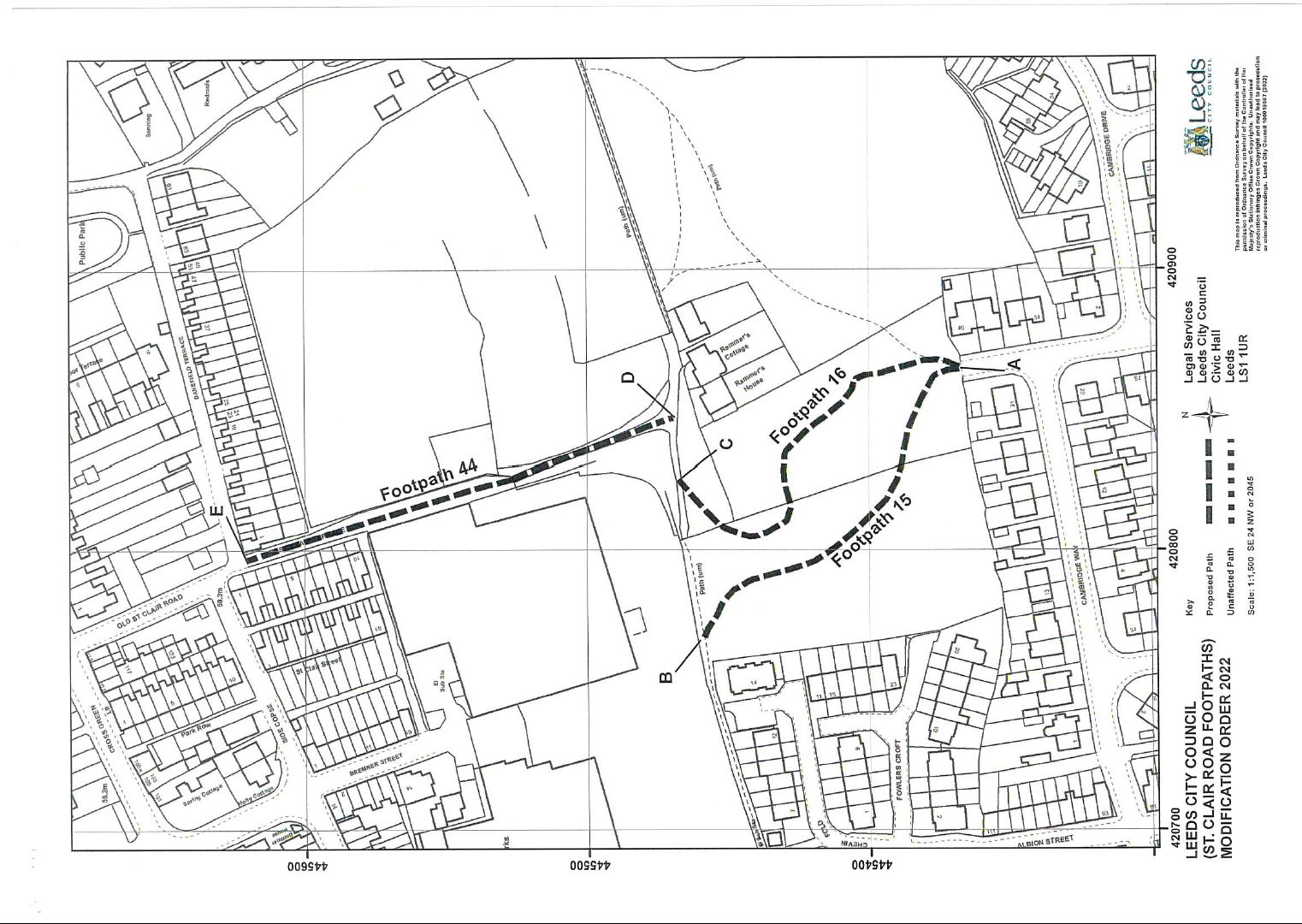
Otley Footpath No. 15 commencing from a point, SE 2086 4537, at the junction with St. Clair Road by number 40 and proceeding for a distance of 142 metres to a point, SE 2077 4546, at the junction with Otley Footpath No. 11 behind 14 Chevin Fold.
Otley Footpath No. 16 commencing from a point, SE 2086 4537, at the junction with St. Clair Road by number 40 and proceeding for a distance of 148 metres to a point, SE 2082 4547, at the junction with Otley Footpath No. 11 west of Rammer’s House.
Otley Footpath No. 44 commencing from a point, SE 2084 4547, at the junction with Otley Footpath No. 11 at Rammer’s House and proceeding in a north north westerly direction for a distance of 160 metres to a point, SE 2079 4562, at the junction with Danefield Terrace alongside number 1.
Notice of public path modification order
This Order is made by Leeds City Council under Section 53(2) (b) of the Wildlife and Countryside Act 1981 (‘the Act’) because it appears to that authority that the West Yorkshire Metropolitan County Council (Modified) Definitive Map and Statement (Leeds Metropolitan District) requires modification in consequence of the occurrence of an event specified in Section 53(3)(b) of the Act, namely the expiration of a period such that the enjoyment by the public of the ways during that period raises the presumption that the ways have been dedicated as a public path.
The Authority have consulted with every Local Authority whose area includes land to which the Order relates.
The Leeds City Council hereby order that:
- For the purposes of this Order the relevant date is 1st of February 2022.
- The West Yorkshire Metropolitan County Council Modified or Leeds City Council Definitive Map and Statement (Leeds Metropolitan District) shall be modified as described in Part I and Part II of the Schedule and shown on the map attached to the Order.
- This Order shall take effect on the date it is confirmed and may be cited as the Leeds City Council (St. Clair Road Footpaths) Modification Order 2022.
Dated this 16th May 2022
The common seal of Leeds City Council was hereunto affixed in the presence of:
Gregg Shevill, General Proerty Team Leader, Legal Services
Seal no. 104232
Schedule part I - Modification of Definitive Map
Description of the Path or Way to be Added
Otley Footpath No. 15
Footpath commencing from a Point A, SE 2086 4537, at the junction with St. Clair Road by number 40 and proceeding through a field gate for a distance of 142 metres along a grass surface in a northerly, then a west north westerly, then a north westerly, then a northerly and finally a west north westerly direction to a Point B, SE 2077 4546, at the junction with Otley Footpath No. 11 behind 14 Chevin Fold as shown on the Order Map and having a width of 2 metres.
Otley Footpath No. 16
Footpath commencing from a Point A, SE 2086 4537, at the junction with St. Clair Road by number 40 and proceeding through a field gate for a distance of 148 metres along a grass surface in a northerly, then a north westerly, then a westerly, then a west north westerly, then a north north westerly, then a north north easterly and finally a north easterly direction to a Point C, SE 2082 4547, at the junction with Otley Footpath No. 11 west of Rammer’s House as shown on the Order Map and having a width of 2 metres.
Otley Footpath No. 44
Footpath commencing from a Point D, SE 2084 4547, at the junction with Otley Footpath No. 11 at Rammer’s House and proceeding along Old St. Clair Road in a north north westerly direction for a distance of 61 metres along a stone and grass surface with a width of 3.4 metres, then passing through a field gate at SE 2082 4552, and continuing for a distance of 99 metres along a tarmac surface with a variable width of between 4.8 and 6.8 metres to a Point E, SE 2079 4562, at the junction with Danefield Terrace alongside number 1 as shown on the Order Map.
Schedule part II - Modification of Definitive Statement
Description of the Path or Way to be Added
Path No | 15 | 16 | 44 |
Map Reference | SE 24 NW 2045 | SE 24 NW 2045 | SE 24 NW 2045 |
Description of Route | Footpath commencing from a point, SE 2086 4537, at the junction with St. Clair Road by number 40, and proceeding in a northerly, then a west north westerly, then a north westerly, then a northerly and finally a west north westerly direction to a point, SE 2077 4546, at the junction with Otley Footpath No. 11 behind 14 Chevin Fold | Footpath commencing from a point, SE 2086 4537, at the junction with St. Clair Road by number 40 and proceeding in a northerly, then a north westerly, then a westerly, then a west north westerly, then a north north westerly, then a north north easterly and finally a north easterly direction to a point, SE 2082 4547, at the junction with Otley Footpath No. 11 west of Rammer’s House | Footpath commencing from a point, SE 2084 4547, at the junction with Otley Footpath No. 11 at Rammer’s House and proceeding along Old St. Clair Road in a north north westerly to a point, SE 2079 4562, at the junction with Danefield Terrace alongside number 1 |
Nature of Surface | Grass | Grass | Stone and grass Tarmac |
Length | 142 metres 0.09 miles | 148 metres 0.09 miles | 61 metres 0.04 miles 99 metres 0.06 miles |
Width | 2 metres 6.6 feet | 2 metres 6.5 feet | 3.4 metres 11.2 feet 4.8-6.8 metres 15.7-22.3 feet |
General (Including Path Furniture, Limitations, Conditions) | Field Gate as SE 2086 4537 | Field Gate as SE 2086 4537 | Field Gate at SE 2082 4552 |
Leeds City Council (St Clair Road footpaths) Modification Order 2022
In accordance with Schedule 15 of the Wildlife and Countryside Act 1981, Leeds City Council hereby confirms this Order
This 6th day of July 2023
The common seal of Leeds City Council was hereunto affixed
Duly authorised officer Gregg Shevill, General Property Team Leader, Legal Services
Seal no. 104232
Dated 10 July 2023
Leeds City Council
Civic Hall
Calverley Street
Leeds
LS1 1UR
