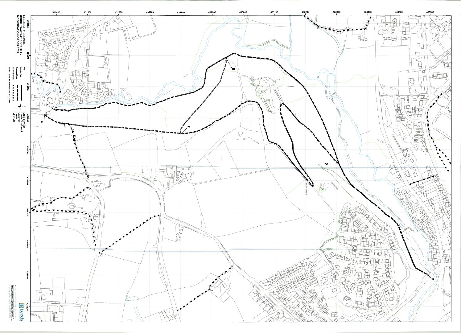
The above Order made on 12 January 2021, under Section 53 of the Wildlife and Countryside Act 1981, if confirmed as made, will modify the Definitive Map and Statement for the area by upgrading to bridleway Leeds Public Footpath No. 156 from SE 2397 3239 at the junction with Troydale Lane to SE 2450 3359 at the junction with Wood Lane and upgrading to bridleway Leeds Public Footpath No. 157 from SE 2399 3236 at the junction with Troydale Lane to SE 2414 3331 at the junction with Leeds Public Bridleway No. 156 and by adding a bridleway between SE 2381 3294 at the junction with Leeds Bridleway No. 156 to SE 2405 3280 at the junction with Leeds Bridleway No. 157.
It will also amend the Statement for Leeds Public Footpath No. 157 between SE 2402 3244 at the junction with Leeds Public Bridleway No. 157 and 2418 3249 at the junction with Tong Road which will remain as a footpath and be renumbered.
A copy of the order and the order map may be seen at Parks and Countryside Reception, Farnley Hall, Hall Lane, Farnley, LS12 5HA (Legals reference 137822), and also at Pudsey Library, Church Lane, Pudsey, Leeds LS28 7TY during normal opening hours until 2 November 2023. Copies of the Order and Map may also be viewed obtained by emailing prow@leeds.gov.uk or calling 0113 378 8625
Any representation or objection relating to the Order must be sent in writing to Legal Services, Leeds City Council, Civic Hall, Calverley Street, Leeds LS1 1UR, (Quoting reference 13782), not later than 2 November 2023, and applicants are requested to state the grounds on which it is made.
If no representations or objections are duly made to the Order, or if any so made are withdrawn, the Leeds City Council, instead of submitting the Order to the Secretary of State for the Environment Food and Rural Affairs may itself confirm the Order. If the Order is submitted to the Secretary of State for the Environment Food and Rural Affairs any representations or objections which have been duly made and not withdrawn will be sent with it.
Notice of public path modification order
This Order is made by Leeds City Council under Section 53(2) (b) of the Wildlife and Countryside Act 1981 (‘the Act’) because it appears to that authority that the West Yorkshire Metropolitan County Council Modified Definitive Map and Statement (Leeds Metropolitan District) require modification in consequence of the occurrence of an event specified in Section 53(3)(c)(i), namely that a right of way which is not shown in the map and statement subsists or is reasonably alleged to subsist and Section 53(3)(c)(ii) that a highway shown in the map and statement as a highway of a particular description ought to be there shown as a highway of a different description and Section 53(3)(c)(iii) that particulars contained in the map and statement require modification.
The Authority have consulted with every Local Authority whose area includes land to which the Order relates.
The Leeds City Council hereby order that:
- For the purposes of this Order the relevant date is the 1st of November 2020
- The West Yorkshire Metropolitan County Council Modified or Leeds City Council Definitive Map and Statement (Leeds Metropolitan District) shall be modified as described in Part I and Part II of the Schedule and shown on the map attached to the Order.
- This Order shall take effect on the date it is confirmed and may be cited as the Leeds City Council (Bridleways at Post Hill) Modification Order 2020.
Dated this 12 January 2021
The common seal of Leeds City Council was hereunto affixed in the presence of:
Sarah Blenkin, Commercial Property Team Leader, Legal Services
Seal no. 101334
Schedule part I - Modification of Definitive Map
Description of the Paths or Ways to be Upgraded
Leeds Bridleway No. 156
Bridleway commencing from a Point A, SE 2397 3239, at the junction with Troydale Lane at the eastern end of the bridge over Pudsey Beck and proceeding for a distance of 1658 metres along a crushed stone surface with some cart stone slabs in a generally northerly direction to Post Hill, then a westerly, then a north north westerly, then a northerly, then a north easterly, then an east north easterly, then a north easterly, then an east north easterly and finally a north north easterly direction to a Point B, SE 2450 3359, at the junction with Wood Lane at the south eastern end of the bridge over Pudsey Beck as shown on the Order Map and having a variable width of between 2.3 and 3 metres for its full length.
Leeds Bridleway No. 157
Bridleway commencing from a Point C, SE 2399 3236, at the junction with Troydale Lane and proceeding for a distance of 1614 metres along a stone and earth surface in a north easterly, then a northerly, then a north westerly direction to Post Hill and then a northerly, then an easterly, then a northerly, then a north easterly direction to Park Springs then a south westerly, then a west south westerly, and finally a north easterly direction to a Point D SE 2414 3331, at the junction with Leeds Public Bridleway No. 156 as shown on the Order Map and having a variable width of between 1.3 and 3 metres.
Description of the Path or Way to be Added
Leeds Bridleway No. 300
Bridleway commencing from a Point E, SE 2381 3294, at the junction with Leeds Bridleway No. 156 by the start of the Hill Climb, and proceeding for a distance of 290 metres along a stone and earth surface in an easterly then an east south easterly, then a south easterly and finally a north easterly direction to a Point F, SE 2405 3280, at the junction with Leeds Bridleway No. 157 as shown on the Order Map and having a width of 3 metres.
Schedule part II - Modification of Definitive Statement
Description of the Paths or Ways to be Upgraded, Added and Amended
| Path No | 156 | 157 | 300 | 301 |
| Map Reference | SE 23 SW 2332, 2333, & 2433 | SE 23 SW SE 2332, 2333, 2432 & 2433 | SE 23 SW 2332 & 2432 | SE 23 SW 2432 |
| Description of Route | Bridleway commencing from a point, SE 2397 3239, at the junction with Troydale Lane at the eastern end of the bridge over Pudsey Beck and proceeding in a generally northerly direction to Post Hill, then a westerly, then a north north westerly, then a northerly, then a north easterly, then an east north easterly, then a north easterly, then and east north eastern and finally a north north easterly direction to a point, SE 2450 3359, at the junction with Wood Lane at the south eastern end of the bridge over Pudsey Beck | Bridleway commencing from a point, SE 2399 3236, at the junction with Troydale Lane and proceeding in a north easterly, then a northerly, then a north westerly direction to Post Hill and then a northerly, then an easterly, then a northerly, then a north easterly direction to Park Springs then a south westerly, then a west south westerly, and finally a north easterly direction to a point SE 2414 3331, at the junction with Leeds Public Bridleway No. 156 | Bridleway commencing from a Point E, SE 2381 3294, at the junction with Leeds Bridleway No. 156 by the start of the Hill Climb, and proceeding in an easterly then an east south easterly, then a south easterly and finally a north easterly direction to a point, SE 2405 3280, at the junction with Leeds Bridleway No. 157 | Footpath commencing from a point, SE 2402 3244, at the junction with Leeds Public Bridleway No. 157 and proceeding in an east north easterly direction to a point, SE 2418 3249 at the junction with Tong Road opposite the Beulah Public House |
| Nature of Surface | Crushed Stone with some Cart Stone Slabs | Stone and Earth | Stone and Earth | Grass and Earth |
| Length | 1655 metres, 1.03 miles | 1614 metres, 1 mile | 290 metres, 0.18 miles | 178 metres, 0.11 miles |
| Width | 2.3-3 metres, 7.5-9.8 feet | 1.3-3 metres, 4.2-9.8 feet | 3 metres, 9.8 feet | 0.9 metres, 3 feet |
| General (Including Path Furniture, Limitations, Conditions) | 1.5 metre wide gate with a Stone Squeeze Stile and 5 Stone Steps alongside at SE 2397 3239 Kissing Gate and Field Gate SE 2450 3359 | 1.5 metre wide Stone Squeeze stile and 2 Steps at SE 2399 3236 9 Sleeper Steps at SE 2401 3241 | 4 Wide Sleeper Steps at SE 2401 3242 | 10 Sleeper Steps at SE 2403 3245 Gap and 3 Stone Steps at SE 2406 3245 | Gap SE 2418 3249 Originally Part of Leeds 157 |
Statement of reasons
This statement does not form part of the order.
Under the Wildlife & Countryside Act 1981, Leeds City Council, as the Surveying Authority for the Leeds Metropolitan District has a duty to keep the Definitive Map and Statement under continuous review. Councils are under an obligation to consider fully evidence and, if necessary, make Orders to add, delete, amend or reclassify public right of way. A notice that such an Order has been made has to be advertised on the site of the path(s) in question and in the local press. This provides an opportunity for objections or representations to be made to the proposed change.
Leeds City Council has made such an Order to upgrade all of Leeds Footpath No. 156 and most of Leeds Footpath No. 157 to bridleway and also add a bridleway between the two upgraded bridleways and amend the Statement for the section of Leeds Footpath No. 157 that will not be upgraded. Leeds City Council has made the Order because having considered the available evidence including user evidence, historic maps, photos, council records and landowner and occupier statements it believes that bridleway rights exist on these routes at Post Hill. Leeds City Council is satisfied that the Order complies with the legal grounds and tests laid down in Section 53(3)(b)(i), (ii) & (iii) of the Wildlife & Countryside Act 1981, namely that a right of way which is not shown on the Definitive Map and Statement subsists over the area to which the map relates, that two highways shown on the Definitive Map and Statement as footpaths ought to be shown as bridleways, and that other particulars contained in the statement requires modification.
This evidence may be consulted free of charge at Farnley Hall, Hall Lane, Leeds, LS12 5HA between 10am to 5pm, Mondays to Fridays. Please make an appointment by calling 0113 3782875.
Objections or representations relating to the Order must be made in writing by 2 November 2023 to the address given in the Notice. To be relevant, objections or representations should relate to the question of the existence or status of rights of way; other objections or representations (e.g. suitability, desirability, security, safety or maintenance) may be held to be irrelevant.
The City Council will be willing to discuss the concerns of those considering objecting or making representations relating to the Order. Please contact Charlotte Hamer, at Public Rights of Way, Climate Energy and Green Spaces, Farnley Hall, Hall Lane, Leeds LS12 5HA or on 0113 37 88625.
The right of objection to an Order is a statutory right, but it should be exercised in a reasonable manner. The costs involved in dealing with objections to Orders may be awarded against objectors only in cases of unreasonable behaviour.
If there are no objections to the Order, or if any made are withdrawn, the City Council may confirm the Order, and the Definitive Map and Statement will then be modified. If there are any objections which are not withdrawn, the City Council must refer the Order and objections to the Department of the Environment, Food and Rural Affairs. The Department will appoint an independent Inspector to consider the Order and hear the objections, normally by holding a public inquiry. The Inspector may confirm the Order, with or without modifications, or may decide that the Order should not be confirmed.
Dated this 5 October 2023
Leeds City Council
Civic Hall
Calverley Street
Leeds
LS1 1UR
